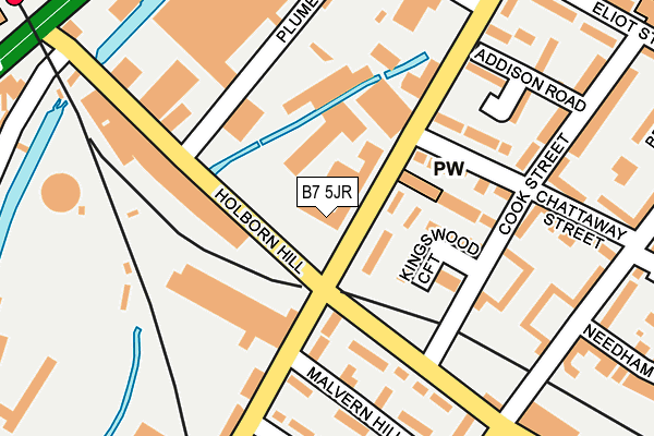
B7 5JR is located in the Nechells electoral ward, within the metropolitan district of Birmingham and the English Parliamentary constituency of Birmingham, Ladywood. The Sub Integrated Care Board (ICB) Location is NHS Birmingham and Solihull ICB - 15E and the police force is West Midlands. This postcode has been in use since May 2019.


GetTheData
Source: OS OpenMap – Local (Ordnance Survey)
Source: OS VectorMap District (Ordnance Survey)
Licence: Open Government Licence (requires attribution)
| Easting | 409079 |
| Northing | 289397 |
| Latitude | 52.502414 |
| Longitude | -1.867677 |
GetTheData
Source: Open Postcode Geo
Licence: Open Government Licence
| Country | England |
| Postcode District | B7 |
➜ See where B7 is on a map ➜ Where is Birmingham? | |
GetTheData
Source: Land Registry Price Paid Data
Licence: Open Government Licence
Elevation or altitude of B7 5JR as distance above sea level:
| Metres | Feet | |
|---|---|---|
| Elevation | 100m | 328ft |
Elevation is measured from the approximate centre of the postcode, to the nearest point on an OS contour line from OS Terrain 50, which has contour spacing of ten vertical metres.
➜ How high above sea level am I? Find the elevation of your current position using your device's GPS.
GetTheData
Source: Open Postcode Elevation
Licence: Open Government Licence
| Ward | Nechells |
| Constituency | Birmingham, Ladywood |
GetTheData
Source: ONS Postcode Database
Licence: Open Government Licence
| Holborn Hill (Long Acre) | Nechells | 25m |
| The Villa Tavern (Holborn Hill) | Nechells | 118m |
| The Villa Tavern (Holborn Hill) | Nechells | 145m |
| Holborn Hill (Nechells Park Rd) | Nechells | 236m |
| Holborn Hill (Nechells Park Rd) | Nechells | 263m |
| Aston Station | 0.4km |
| Duddeston Station | 1.6km |
| Witton (West Midlands) Station | 1.6km |
GetTheData
Source: NaPTAN
Licence: Open Government Licence
GetTheData
Source: ONS Postcode Database
Licence: Open Government Licence


➜ Get more ratings from the Food Standards Agency
GetTheData
Source: Food Standards Agency
Licence: FSA terms & conditions
| Last Collection | |||
|---|---|---|---|
| Location | Mon-Fri | Sat | Distance |
| Nechells Park Road Post Office | 18:30 | 12:30 | 281m |
| Nechells Park Road /Stanley Road | 17:30 | 12:30 | 311m |
| Aston Hall Road / Union Road | 17:30 | 12:30 | 500m |
GetTheData
Source: Dracos
Licence: Creative Commons Attribution-ShareAlike
The below table lists the International Territorial Level (ITL) codes (formerly Nomenclature of Territorial Units for Statistics (NUTS) codes) and Local Administrative Units (LAU) codes for B7 5JR:
| ITL 1 Code | Name |
|---|---|
| TLG | West Midlands (England) |
| ITL 2 Code | Name |
| TLG3 | West Midlands |
| ITL 3 Code | Name |
| TLG31 | Birmingham |
| LAU 1 Code | Name |
| E08000025 | Birmingham |
GetTheData
Source: ONS Postcode Directory
Licence: Open Government Licence
The below table lists the Census Output Area (OA), Lower Layer Super Output Area (LSOA), and Middle Layer Super Output Area (MSOA) for B7 5JR:
| Code | Name | |
|---|---|---|
| OA | E00046662 | |
| LSOA | E01009203 | Birmingham 043C |
| MSOA | E02001869 | Birmingham 043 |
GetTheData
Source: ONS Postcode Directory
Licence: Open Government Licence
| B7 5JP | Long Acre | 56m |
| B7 5LQ | Kingswood Croft | 85m |
| B7 5PA | Holborn Hill | 135m |
| B7 5LP | Cook Street | 167m |
| B7 5NX | Malvern Hill Road | 176m |
| B6 7RT | Plume Street | 207m |
| B7 5LN | Chattaway Street | 215m |
| B7 5NS | Butlin Street | 218m |
| B7 5PD | Nechells Park Road | 229m |
| B7 5NY | Nechells Park Road | 230m |
GetTheData
Source: Open Postcode Geo; Land Registry Price Paid Data
Licence: Open Government Licence