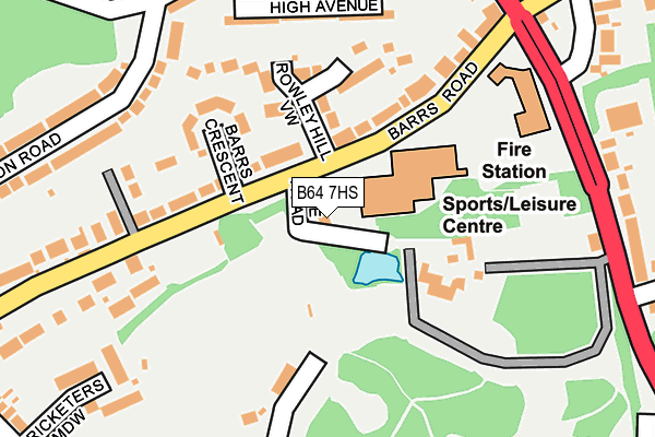
B64 7HS lies on Lee Road in Cradley Heath. B64 7HS is located in the Cradley Heath and Old Hill electoral ward, within the metropolitan district of Sandwell and the English Parliamentary constituency of Halesowen and Rowley Regis. The Sub Integrated Care Board (ICB) Location is NHS Black Country ICB - D2P2L and the police force is West Midlands. This postcode has been in use since March 1982.


GetTheData
Source: OS OpenMap – Local (Ordnance Survey)
Source: OS VectorMap District (Ordnance Survey)
Licence: Open Government Licence (requires attribution)
| Easting | 395768 |
| Northing | 285609 |
| Latitude | 52.468402 |
| Longitude | -2.063724 |
GetTheData
Source: Open Postcode Geo
Licence: Open Government Licence
| Street | Lee Road |
| Town/City | Cradley Heath |
| Country | England |
| Postcode District | B64 |
➜ See where B64 is on a map ➜ Where is Cradley Heath? | |
GetTheData
Source: Land Registry Price Paid Data
Licence: Open Government Licence
Elevation or altitude of B64 7HS as distance above sea level:
| Metres | Feet | |
|---|---|---|
| Elevation | 150m | 492ft |
Elevation is measured from the approximate centre of the postcode, to the nearest point on an OS contour line from OS Terrain 50, which has contour spacing of ten vertical metres.
➜ How high above sea level am I? Find the elevation of your current position using your device's GPS.
GetTheData
Source: Open Postcode Elevation
Licence: Open Government Licence
| Ward | Cradley Heath And Old Hill |
| Constituency | Halesowen And Rowley Regis |
GetTheData
Source: ONS Postcode Database
Licence: Open Government Licence
2016 14 JUN £170,000 |
2012 22 OCT £160,000 |
1, LEE ROAD, CRADLEY HEATH, B64 7HS 2005 15 AUG £150,000 |
5, LEE ROAD, CRADLEY HEATH, B64 7HS 2000 3 NOV £119,950 |
2000 26 MAY £119,000 |
GetTheData
Source: HM Land Registry Price Paid Data
Licence: Contains HM Land Registry data © Crown copyright and database right 2025. This data is licensed under the Open Government Licence v3.0.
| Haden Hill Leisure Centre (Barrs Rd) | Haden Hill | 95m |
| Haden Hill Leisure Centre (Barrs Rd) | Haden Hill | 121m |
| High Avenue (Harcourt Rd) | Haden Hill | 235m |
| High Avenue (Harcourt Rd) | Haden Hill | 241m |
| Barrs Road (Halesowen Rd) | Haden Hill | 241m |
| Old Hill Station | 0.6km |
| Cradley Heath Station | 1.8km |
| Rowley Regis Station | 2.4km |
GetTheData
Source: NaPTAN
Licence: Open Government Licence
| Percentage of properties with Next Generation Access | 100.0% |
| Percentage of properties with Superfast Broadband | 100.0% |
| Percentage of properties with Ultrafast Broadband | 100.0% |
| Percentage of properties with Full Fibre Broadband | 0.0% |
Superfast Broadband is between 30Mbps and 300Mbps
Ultrafast Broadband is > 300Mbps
| Percentage of properties unable to receive 2Mbps | 0.0% |
| Percentage of properties unable to receive 5Mbps | 0.0% |
| Percentage of properties unable to receive 10Mbps | 0.0% |
| Percentage of properties unable to receive 30Mbps | 0.0% |
GetTheData
Source: Ofcom
Licence: Ofcom Terms of Use (requires attribution)
GetTheData
Source: ONS Postcode Database
Licence: Open Government Licence


➜ Get more ratings from the Food Standards Agency
GetTheData
Source: Food Standards Agency
Licence: FSA terms & conditions
| Last Collection | |||
|---|---|---|---|
| Location | Mon-Fri | Sat | Distance |
| Halesowen Road / Harcourt Road | 17:30 | 12:00 | 293m |
| Station Road / Penn St | 17:30 | 12:00 | 457m |
| High Haden Road Between High Had | 17:30 | 12:00 | 506m |
GetTheData
Source: Dracos
Licence: Creative Commons Attribution-ShareAlike
The below table lists the International Territorial Level (ITL) codes (formerly Nomenclature of Territorial Units for Statistics (NUTS) codes) and Local Administrative Units (LAU) codes for B64 7HS:
| ITL 1 Code | Name |
|---|---|
| TLG | West Midlands (England) |
| ITL 2 Code | Name |
| TLG3 | West Midlands |
| ITL 3 Code | Name |
| TLG37 | Sandwell |
| LAU 1 Code | Name |
| E08000028 | Sandwell |
GetTheData
Source: ONS Postcode Directory
Licence: Open Government Licence
The below table lists the Census Output Area (OA), Lower Layer Super Output Area (LSOA), and Middle Layer Super Output Area (MSOA) for B64 7HS:
| Code | Name | |
|---|---|---|
| OA | E00050352 | |
| LSOA | E01009958 | Sandwell 038D |
| MSOA | E02002080 | Sandwell 038 |
GetTheData
Source: ONS Postcode Directory
Licence: Open Government Licence
| B64 7EX | Barrs Road | 112m |
| B64 7ER | Rowley Hill View | 138m |
| B64 7EY | Barrs Crescent | 155m |
| B64 7ET | Hollies Rise | 186m |
| B64 7HW | High Avenue | 186m |
| B64 7JU | Halesowen Road | 214m |
| B64 7HN | Harcourt Road | 231m |
| B64 7EZ | Barrs Road | 244m |
| B64 7HL | Trejon Road | 244m |
| B64 7HP | Harcourt Road | 255m |
GetTheData
Source: Open Postcode Geo; Land Registry Price Paid Data
Licence: Open Government Licence