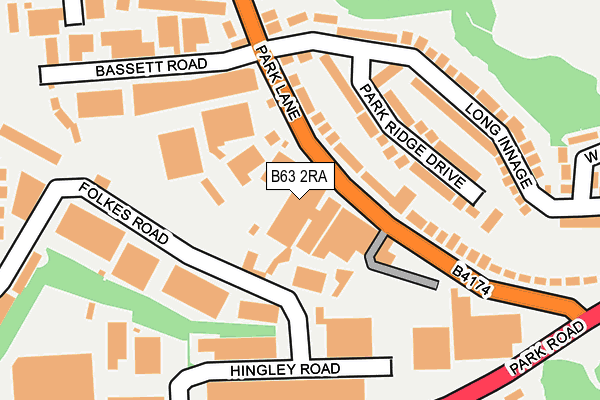
B63 2RA lies on Park Lane in Halesowen. B63 2RA is located in the Cradley and Wollescote electoral ward, within the metropolitan district of Dudley and the English Parliamentary constituency of Stourbridge. The Sub Integrated Care Board (ICB) Location is NHS Black Country ICB - D2P2L and the police force is West Midlands. This postcode has been in use since January 1980.


GetTheData
Source: OS OpenMap – Local (Ordnance Survey)
Source: OS VectorMap District (Ordnance Survey)
Licence: Open Government Licence (requires attribution)
| Easting | 393548 |
| Northing | 284695 |
| Latitude | 52.460178 |
| Longitude | -2.096379 |
GetTheData
Source: Open Postcode Geo
Licence: Open Government Licence
| Street | Park Lane |
| Town/City | Halesowen |
| Country | England |
| Postcode District | B63 |
➜ See where B63 is on a map ➜ Where is Halesowen? | |
GetTheData
Source: Land Registry Price Paid Data
Licence: Open Government Licence
Elevation or altitude of B63 2RA as distance above sea level:
| Metres | Feet | |
|---|---|---|
| Elevation | 100m | 328ft |
Elevation is measured from the approximate centre of the postcode, to the nearest point on an OS contour line from OS Terrain 50, which has contour spacing of ten vertical metres.
➜ How high above sea level am I? Find the elevation of your current position using your device's GPS.
GetTheData
Source: Open Postcode Elevation
Licence: Open Government Licence
| Ward | Cradley And Wollescote |
| Constituency | Stourbridge |
GetTheData
Source: ONS Postcode Database
Licence: Open Government Licence
| Bassett Rd (Park Lane) | Netherend | 168m |
| Bassett Rd (Park Lane) | Netherend | 171m |
| Hingley Rd (Park Rd) | Colley Gate | 277m |
| Park Lane (Park Rd) | Colley Gate | 296m |
| Hingley Rd (Park Rd) | Colley Gate | 322m |
| Cradley Heath Station | 1.1km |
| Lye (West Midlands) Station | 1.3km |
| Stourbridge Junction Station | 2.9km |
GetTheData
Source: NaPTAN
Licence: Open Government Licence
GetTheData
Source: ONS Postcode Database
Licence: Open Government Licence


➜ Get more ratings from the Food Standards Agency
GetTheData
Source: Food Standards Agency
Licence: FSA terms & conditions
| Last Collection | |||
|---|---|---|---|
| Location | Mon-Fri | Sat | Distance |
| Park Lane / Park Road | 17:15 | 12:00 | 286m |
| Hayes Lane | 18:30 | 10:30 | 456m |
| Netherend Lane | 17:15 | 12:00 | 485m |
GetTheData
Source: Dracos
Licence: Creative Commons Attribution-ShareAlike
The below table lists the International Territorial Level (ITL) codes (formerly Nomenclature of Territorial Units for Statistics (NUTS) codes) and Local Administrative Units (LAU) codes for B63 2RA:
| ITL 1 Code | Name |
|---|---|
| TLG | West Midlands (England) |
| ITL 2 Code | Name |
| TLG3 | West Midlands |
| ITL 3 Code | Name |
| TLG36 | Dudley |
| LAU 1 Code | Name |
| E08000027 | Dudley |
GetTheData
Source: ONS Postcode Directory
Licence: Open Government Licence
The below table lists the Census Output Area (OA), Lower Layer Super Output Area (LSOA), and Middle Layer Super Output Area (MSOA) for B63 2RA:
| Code | Name | |
|---|---|---|
| OA | E00049894 | |
| LSOA | E01009862 | Dudley 033D |
| MSOA | E02002032 | Dudley 033 |
GetTheData
Source: ONS Postcode Directory
Licence: Open Government Licence
| B63 2UZ | Park Ridge Drive | 112m |
| B63 2NT | Park Lane | 121m |
| B63 2UY | Long Innage | 158m |
| B63 2NP | Park Lane | 173m |
| B63 2RG | Park Road | 276m |
| B63 2UT | West Road South | 305m |
| B63 2QT | James Scott Road | 323m |
| B63 2UU | Long Innage | 333m |
| B63 2NS | Park Road | 338m |
| B63 2RH | Tipper Trading Estate | 395m |
GetTheData
Source: Open Postcode Geo; Land Registry Price Paid Data
Licence: Open Government Licence