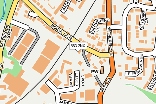
B63 2NX lies on Netherend Square in Halesowen. B63 2NX is located in the Cradley and Wollescote electoral ward, within the metropolitan district of Dudley and the English Parliamentary constituency of Stourbridge. The Sub Integrated Care Board (ICB) Location is NHS Black Country ICB - D2P2L and the police force is West Midlands. This postcode has been in use since January 1980.


GetTheData
Source: OS OpenMap – Local (Ordnance Survey)
Source: OS VectorMap District (Ordnance Survey)
Licence: Open Government Licence (requires attribution)
| Easting | 393386 |
| Northing | 285154 |
| Latitude | 52.464302 |
| Longitude | -2.098773 |
GetTheData
Source: Open Postcode Geo
Licence: Open Government Licence
| Street | Netherend Square |
| Town/City | Halesowen |
| Country | England |
| Postcode District | B63 |
➜ See where B63 is on a map ➜ Where is Halesowen? | |
GetTheData
Source: Land Registry Price Paid Data
Licence: Open Government Licence
Elevation or altitude of B63 2NX as distance above sea level:
| Metres | Feet | |
|---|---|---|
| Elevation | 100m | 328ft |
Elevation is measured from the approximate centre of the postcode, to the nearest point on an OS contour line from OS Terrain 50, which has contour spacing of ten vertical metres.
➜ How high above sea level am I? Find the elevation of your current position using your device's GPS.
GetTheData
Source: Open Postcode Elevation
Licence: Open Government Licence
| Ward | Cradley And Wollescote |
| Constituency | Stourbridge |
GetTheData
Source: ONS Postcode Database
Licence: Open Government Licence
| Netherend Square (Mogul Lane) | Netherend | 36m |
| Netherend Lane (Mogul Lane) | Netherend | 52m |
| Netherend Lane (Mogul Lane) | Netherend | 103m |
| Mogul Lane (Netherend Lane) | Netherend | 120m |
| Mogul Lane (Netherend Lane) | Netherend | 127m |
| Cradley Heath Station | 0.8km |
| Lye (West Midlands) Station | 1.3km |
| Old Hill Station | 3km |
GetTheData
Source: NaPTAN
Licence: Open Government Licence
| Percentage of properties with Next Generation Access | 100.0% |
| Percentage of properties with Superfast Broadband | 100.0% |
| Percentage of properties with Ultrafast Broadband | 100.0% |
| Percentage of properties with Full Fibre Broadband | 0.0% |
Superfast Broadband is between 30Mbps and 300Mbps
Ultrafast Broadband is > 300Mbps
| Percentage of properties unable to receive 2Mbps | 0.0% |
| Percentage of properties unable to receive 5Mbps | 0.0% |
| Percentage of properties unable to receive 10Mbps | 0.0% |
| Percentage of properties unable to receive 30Mbps | 0.0% |
GetTheData
Source: Ofcom
Licence: Ofcom Terms of Use (requires attribution)
GetTheData
Source: ONS Postcode Database
Licence: Open Government Licence


➜ Get more ratings from the Food Standards Agency
GetTheData
Source: Food Standards Agency
Licence: FSA terms & conditions
| Last Collection | |||
|---|---|---|---|
| Location | Mon-Fri | Sat | Distance |
| Netherend Lane | 17:15 | 12:00 | 28m |
| Hayes Lane | 18:30 | 10:30 | 463m |
| Lye Meter Box | 18:30 | 474m | |
GetTheData
Source: Dracos
Licence: Creative Commons Attribution-ShareAlike
The below table lists the International Territorial Level (ITL) codes (formerly Nomenclature of Territorial Units for Statistics (NUTS) codes) and Local Administrative Units (LAU) codes for B63 2NX:
| ITL 1 Code | Name |
|---|---|
| TLG | West Midlands (England) |
| ITL 2 Code | Name |
| TLG3 | West Midlands |
| ITL 3 Code | Name |
| TLG36 | Dudley |
| LAU 1 Code | Name |
| E08000027 | Dudley |
GetTheData
Source: ONS Postcode Directory
Licence: Open Government Licence
The below table lists the Census Output Area (OA), Lower Layer Super Output Area (LSOA), and Middle Layer Super Output Area (MSOA) for B63 2NX:
| Code | Name | |
|---|---|---|
| OA | E00049924 | |
| LSOA | E01009869 | Dudley 032C |
| MSOA | E02002031 | Dudley 032 |
GetTheData
Source: ONS Postcode Directory
Licence: Open Government Licence
| B63 2QQ | Mogul Lane | 41m |
| B63 2QN | Mogul Lane | 52m |
| B63 2PB | Netherend Close | 135m |
| B63 2QG | Mogul Lane | 166m |
| B63 2PA | Netherend Lane | 186m |
| B63 2QW | Mogul Lane | 199m |
| B63 2PN | Apperley Way | 200m |
| B63 2PW | Pippin Avenue | 217m |
| B63 2QT | James Scott Road | 221m |
| B63 2QU | Saltbrook Road | 226m |
GetTheData
Source: Open Postcode Geo; Land Registry Price Paid Data
Licence: Open Government Licence