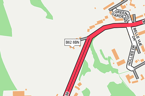
B62 8BN lies on Mucklow Hill in Halesowen. B62 8BN is located in the Halesowen North electoral ward, within the metropolitan district of Dudley and the English Parliamentary constituency of Halesowen and Rowley Regis. The Sub Integrated Care Board (ICB) Location is NHS Black Country ICB - D2P2L and the police force is West Midlands. This postcode has been in use since January 1992.


GetTheData
Source: OS OpenMap – Local (Ordnance Survey)
Source: OS VectorMap District (Ordnance Survey)
Licence: Open Government Licence (requires attribution)
| Easting | 397766 |
| Northing | 284695 |
| Latitude | 52.460212 |
| Longitude | -2.034301 |
GetTheData
Source: Open Postcode Geo
Licence: Open Government Licence
| Street | Mucklow Hill |
| Town/City | Halesowen |
| Country | England |
| Postcode District | B62 |
➜ See where B62 is on a map ➜ Where is Halesowen? | |
GetTheData
Source: Land Registry Price Paid Data
Licence: Open Government Licence
Elevation or altitude of B62 8BN as distance above sea level:
| Metres | Feet | |
|---|---|---|
| Elevation | 200m | 656ft |
Elevation is measured from the approximate centre of the postcode, to the nearest point on an OS contour line from OS Terrain 50, which has contour spacing of ten vertical metres.
➜ How high above sea level am I? Find the elevation of your current position using your device's GPS.
GetTheData
Source: Open Postcode Elevation
Licence: Open Government Licence
| Ward | Halesowen North |
| Constituency | Halesowen And Rowley Regis |
GetTheData
Source: ONS Postcode Database
Licence: Open Government Licence
66, MUCKLOW HILL, HALESOWEN, B62 8BN 2015 30 JUL £534,000 |
68, MUCKLOW HILL, HALESOWEN, B62 8BN 1999 20 DEC £205,000 |
GetTheData
Source: HM Land Registry Price Paid Data
Licence: Contains HM Land Registry data © Crown copyright and database right 2025. This data is licensed under the Open Government Licence v3.0.
| Belle Vue Drive (Mucklow Hill) | Hurst Green | 270m |
| Belle Vue Drive (Mucklow Hill) | Hurst Green | 313m |
| Radcliffe Drive (Kent Rd) | Hurst Green | 480m |
| Radcliffe Drive (Kent Rd) | Hurst Green | 505m |
| Greenhill Rd (Long Lane) | Hurst Green | 542m |
| Old Hill Station | 1.9km |
| Rowley Regis Station | 1.9km |
| Cradley Heath Station | 4km |
GetTheData
Source: NaPTAN
Licence: Open Government Licence
| Percentage of properties with Next Generation Access | 100.0% |
| Percentage of properties with Superfast Broadband | 100.0% |
| Percentage of properties with Ultrafast Broadband | 100.0% |
| Percentage of properties with Full Fibre Broadband | 0.0% |
Superfast Broadband is between 30Mbps and 300Mbps
Ultrafast Broadband is > 300Mbps
| Percentage of properties unable to receive 2Mbps | 0.0% |
| Percentage of properties unable to receive 5Mbps | 0.0% |
| Percentage of properties unable to receive 10Mbps | 0.0% |
| Percentage of properties unable to receive 30Mbps | 0.0% |
GetTheData
Source: Ofcom
Licence: Ofcom Terms of Use (requires attribution)
GetTheData
Source: ONS Postcode Database
Licence: Open Government Licence


➜ Get more ratings from the Food Standards Agency
GetTheData
Source: Food Standards Agency
Licence: FSA terms & conditions
| Last Collection | |||
|---|---|---|---|
| Location | Mon-Fri | Sat | Distance |
| Halesowen Road Post Office | 17:15 | 12:00 | 499m |
| Mucklow Hill | 17:45 | 12:00 | 541m |
| Stewart Road / Ridgefield Road | 17:15 | 12:00 | 704m |
GetTheData
Source: Dracos
Licence: Creative Commons Attribution-ShareAlike
The below table lists the International Territorial Level (ITL) codes (formerly Nomenclature of Territorial Units for Statistics (NUTS) codes) and Local Administrative Units (LAU) codes for B62 8BN:
| ITL 1 Code | Name |
|---|---|
| TLG | West Midlands (England) |
| ITL 2 Code | Name |
| TLG3 | West Midlands |
| ITL 3 Code | Name |
| TLG36 | Dudley |
| LAU 1 Code | Name |
| E08000027 | Dudley |
GetTheData
Source: ONS Postcode Directory
Licence: Open Government Licence
The below table lists the Census Output Area (OA), Lower Layer Super Output Area (LSOA), and Middle Layer Super Output Area (MSOA) for B62 8BN:
| Code | Name | |
|---|---|---|
| OA | E00049545 | |
| LSOA | E01009796 | Dudley 026D |
| MSOA | E02002025 | Dudley 026 |
GetTheData
Source: ONS Postcode Directory
Licence: Open Government Licence
| B62 8BL | Mucklow Hill | 170m |
| B62 8BT | Mucklow Hill | 203m |
| B62 8BU | Mucklow Hill | 233m |
| B62 8NU | Belle Vue Drive | 289m |
| B62 8NX | Hollies Drive | 316m |
| B62 8HA | Greenhill Road | 319m |
| B62 8BW | Mucklow Hill | 329m |
| B62 8BS | Mucklow Hill | 361m |
| B62 8NT | Mucklow Hill | 367m |
| B62 8EZ | Greenhill Road | 387m |
GetTheData
Source: Open Postcode Geo; Land Registry Price Paid Data
Licence: Open Government Licence