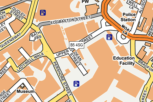
B5 4SG lies on Upper Dean Street in Birmingham. B5 4SG is located in the Bordesley & Highgate electoral ward, within the metropolitan district of Birmingham and the English Parliamentary constituency of Birmingham, Ladywood. The Sub Integrated Care Board (ICB) Location is NHS Birmingham and Solihull ICB - 15E and the police force is West Midlands. This postcode has been in use since October 1985.


GetTheData
Source: OS OpenMap – Local (Ordnance Survey)
Source: OS VectorMap District (Ordnance Survey)
Licence: Open Government Licence (requires attribution)
| Easting | 407290 |
| Northing | 286399 |
| Latitude | 52.475474 |
| Longitude | -1.894101 |
GetTheData
Source: Open Postcode Geo
Licence: Open Government Licence
| Street | Upper Dean Street |
| Town/City | Birmingham |
| Country | England |
| Postcode District | B5 |
➜ See where B5 is on a map ➜ Where is Birmingham? | |
GetTheData
Source: Land Registry Price Paid Data
Licence: Open Government Licence
Elevation or altitude of B5 4SG as distance above sea level:
| Metres | Feet | |
|---|---|---|
| Elevation | 110m | 361ft |
Elevation is measured from the approximate centre of the postcode, to the nearest point on an OS contour line from OS Terrain 50, which has contour spacing of ten vertical metres.
➜ How high above sea level am I? Find the elevation of your current position using your device's GPS.
GetTheData
Source: Open Postcode Elevation
Licence: Open Government Licence
| Ward | Bordesley & Highgate |
| Constituency | Birmingham, Ladywood |
GetTheData
Source: ONS Postcode Database
Licence: Open Government Licence
| Markets (Upper Dean St) | Digbeth | 18m |
| Markets (Upper Dean St) | Digbeth | 35m |
| Markets (Upper Dean St) | Digbeth | 70m |
| Bromsgrove St (Pershore St) | Digbeth | 102m |
| Markets (Upper Dean St) | Digbeth | 113m |
| Grand Central New Street (Midland Metro Stop) (Stephenson Street) | Birmingham | 497m |
| Corporation Street (Midland Metro Stop) (Corporation Street) | Birmingham | 529m |
| Bull Street (Midland Metro Stop) (Bull Street) | Birmingham | 727m |
| Snow Hill (Midland Metro Stop) (Colmore Row) | Birmingham | 965m |
| St Paul's (Midland Metro Stop) (Livery Street) | Jewellery Quarter | 1,412m |
| Birmingham Moor Street Station | 0.4km |
| Birmingham New Street Station | 0.5km |
| Birmingham Snow Hill Station | 0.9km |
GetTheData
Source: NaPTAN
Licence: Open Government Licence
Estimated total energy consumption in B5 4SG by fuel type, 2015.
| Consumption (kWh) | 48,804 |
|---|---|
| Meter count | 8 |
| Mean (kWh/meter) | 6,101 |
| Median (kWh/meter) | 6,331 |
GetTheData
Source: Postcode level gas estimates: 2015 (experimental)
Source: Postcode level electricity estimates: 2015 (experimental)
Licence: Open Government Licence
GetTheData
Source: ONS Postcode Database
Licence: Open Government Licence


➜ Get more ratings from the Food Standards Agency
GetTheData
Source: Food Standards Agency
Licence: FSA terms & conditions
| Last Collection | |||
|---|---|---|---|
| Location | Mon-Fri | Sat | Distance |
| Digbeth / St Martins Lane | 18:30 | 12:00 | 189m |
| Pershore St Markets | 18:30 | 12:30 | 223m |
| Pershore St Markets | 226m | ||
GetTheData
Source: Dracos
Licence: Creative Commons Attribution-ShareAlike
The below table lists the International Territorial Level (ITL) codes (formerly Nomenclature of Territorial Units for Statistics (NUTS) codes) and Local Administrative Units (LAU) codes for B5 4SG:
| ITL 1 Code | Name |
|---|---|
| TLG | West Midlands (England) |
| ITL 2 Code | Name |
| TLG3 | West Midlands |
| ITL 3 Code | Name |
| TLG31 | Birmingham |
| LAU 1 Code | Name |
| E08000025 | Birmingham |
GetTheData
Source: ONS Postcode Directory
Licence: Open Government Licence
The below table lists the Census Output Area (OA), Lower Layer Super Output Area (LSOA), and Middle Layer Super Output Area (MSOA) for B5 4SG:
| Code | Name | |
|---|---|---|
| OA | E00175627 | |
| LSOA | E01033615 | Birmingham 135C |
| MSOA | E02006896 | Birmingham 135 |
GetTheData
Source: ONS Postcode Directory
Licence: Open Government Licence
| B5 4RX | Ladywell Walk | 163m |
| B5 4TD | Ladywell Walk | 200m |
| B5 4BN | Hurst Street | 236m |
| B5 6AB | Bromsgrove Street | 242m |
| B5 6AE | Bromsgrove Street | 242m |
| B5 6AF | Bromsgrove Street | 242m |
| B5 4LJ | Smallbrook Queensway | 245m |
| B5 4TE | Hurst Street | 247m |
| B5 6RY | Hurst Street | 269m |
| B5 6DT | Digbeth | 284m |
GetTheData
Source: Open Postcode Geo; Land Registry Price Paid Data
Licence: Open Government Licence