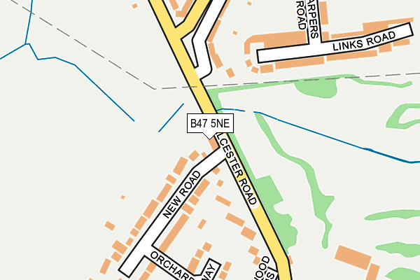
B47 5NE lies on Alcester Road in Hollywood, Birmingham. B47 5NE is located in the Hollywood electoral ward, within the local authority district of Bromsgrove and the English Parliamentary constituency of Bromsgrove. The Sub Integrated Care Board (ICB) Location is NHS Herefordshire and Worcestershire ICB - 18C and the police force is West Mercia. This postcode has been in use since January 1980.


GetTheData
Source: OS OpenMap – Local (Ordnance Survey)
Source: OS VectorMap District (Ordnance Survey)
Licence: Open Government Licence (requires attribution)
| Easting | 408087 |
| Northing | 277902 |
| Latitude | 52.399075 |
| Longitude | -1.882570 |
GetTheData
Source: Open Postcode Geo
Licence: Open Government Licence
| Street | Alcester Road |
| Locality | Hollywood |
| Town/City | Birmingham |
| Country | England |
| Postcode District | B47 |
➜ See where B47 is on a map ➜ Where is Hollywood? | |
GetTheData
Source: Land Registry Price Paid Data
Licence: Open Government Licence
Elevation or altitude of B47 5NE as distance above sea level:
| Metres | Feet | |
|---|---|---|
| Elevation | 150m | 492ft |
Elevation is measured from the approximate centre of the postcode, to the nearest point on an OS contour line from OS Terrain 50, which has contour spacing of ten vertical metres.
➜ How high above sea level am I? Find the elevation of your current position using your device's GPS.
GetTheData
Source: Open Postcode Elevation
Licence: Open Government Licence
| Ward | Hollywood |
| Constituency | Bromsgrove |
GetTheData
Source: ONS Postcode Database
Licence: Open Government Licence
| New Road (Alcester Road South) | Hollywood | 42m |
| New Road (Alcester Road South) | Hollywood | 85m |
| Higher's Heath Lane (Alcester Road South) | Hollywood | 192m |
| Higher's Heath Lane (Alcester Road South) | Hollywood | 253m |
| Post Office (Alcester Road) | Hollywood | 352m |
| Whitlocks End Station | 2.3km |
| Wythall Station | 2.4km |
| Shirley Station | 2.6km |
GetTheData
Source: NaPTAN
Licence: Open Government Licence
| Percentage of properties with Next Generation Access | 100.0% |
| Percentage of properties with Superfast Broadband | 100.0% |
| Percentage of properties with Ultrafast Broadband | 100.0% |
| Percentage of properties with Full Fibre Broadband | 0.0% |
Superfast Broadband is between 30Mbps and 300Mbps
Ultrafast Broadband is > 300Mbps
| Percentage of properties unable to receive 2Mbps | 0.0% |
| Percentage of properties unable to receive 5Mbps | 0.0% |
| Percentage of properties unable to receive 10Mbps | 0.0% |
| Percentage of properties unable to receive 30Mbps | 0.0% |
GetTheData
Source: Ofcom
Licence: Ofcom Terms of Use (requires attribution)
GetTheData
Source: ONS Postcode Database
Licence: Open Government Licence


➜ Get more ratings from the Food Standards Agency
GetTheData
Source: Food Standards Agency
Licence: FSA terms & conditions
| Last Collection | |||
|---|---|---|---|
| Location | Mon-Fri | Sat | Distance |
| Arundel Road / Alcester Road S | 17:45 | 12:00 | 248m |
| Benson Road | 17:30 | 12:00 | 689m |
| Corbett Road / Heath Road | 17:30 | 11:30 | 820m |
GetTheData
Source: Dracos
Licence: Creative Commons Attribution-ShareAlike
The below table lists the International Territorial Level (ITL) codes (formerly Nomenclature of Territorial Units for Statistics (NUTS) codes) and Local Administrative Units (LAU) codes for B47 5NE:
| ITL 1 Code | Name |
|---|---|
| TLG | West Midlands (England) |
| ITL 2 Code | Name |
| TLG1 | Herefordshire, Worcestershire and Warwickshire |
| ITL 3 Code | Name |
| TLG12 | Worcestershire CC |
| LAU 1 Code | Name |
| E07000234 | Bromsgrove |
GetTheData
Source: ONS Postcode Directory
Licence: Open Government Licence
The below table lists the Census Output Area (OA), Lower Layer Super Output Area (LSOA), and Middle Layer Super Output Area (MSOA) for B47 5NE:
| Code | Name | |
|---|---|---|
| OA | E00163969 | |
| LSOA | E01032145 | Bromsgrove 004C |
| MSOA | E02006699 | Bromsgrove 004 |
GetTheData
Source: ONS Postcode Directory
Licence: Open Government Licence
| B47 5NL | Alcester Road | 119m |
| B47 5ND | New Road | 138m |
| B47 5NB | Alcester Road | 140m |
| B14 5TX | Alcester Road South | 198m |
| B47 5NH | Orchard Way | 202m |
| B47 5NP | Alcester Road | 205m |
| B14 4TP | Links Road | 206m |
| B14 4TR | Highters Heath Lane | 215m |
| B14 4TW | Links Road | 221m |
| B14 4TN | Harpers Road | 229m |
GetTheData
Source: Open Postcode Geo; Land Registry Price Paid Data
Licence: Open Government Licence