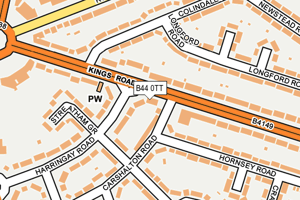
B44 0TT lies on Kings Road in Kingstanding, Birmingham. B44 0TT is located in the Kingstanding electoral ward, within the metropolitan district of Birmingham and the English Parliamentary constituency of Birmingham, Erdington. The Sub Integrated Care Board (ICB) Location is NHS Birmingham and Solihull ICB - 15E and the police force is West Midlands. This postcode has been in use since January 1980.


GetTheData
Source: OS OpenMap – Local (Ordnance Survey)
Source: OS VectorMap District (Ordnance Survey)
Licence: Open Government Licence (requires attribution)
| Easting | 408248 |
| Northing | 294902 |
| Latitude | 52.551902 |
| Longitude | -1.879789 |
GetTheData
Source: Open Postcode Geo
Licence: Open Government Licence
| Street | Kings Road |
| Locality | Kingstanding |
| Town/City | Birmingham |
| Country | England |
| Postcode District | B44 |
➜ See where B44 is on a map ➜ Where is Birmingham? | |
GetTheData
Source: Land Registry Price Paid Data
Licence: Open Government Licence
Elevation or altitude of B44 0TT as distance above sea level:
| Metres | Feet | |
|---|---|---|
| Elevation | 140m | 459ft |
Elevation is measured from the approximate centre of the postcode, to the nearest point on an OS contour line from OS Terrain 50, which has contour spacing of ten vertical metres.
➜ How high above sea level am I? Find the elevation of your current position using your device's GPS.
GetTheData
Source: Open Postcode Elevation
Licence: Open Government Licence
| Ward | Kingstanding |
| Constituency | Birmingham, Erdington |
GetTheData
Source: ONS Postcode Database
Licence: Open Government Licence
| Carshalton Rd (Kings Rd) | Kingstanding | 45m |
| Carshalton Rd (Kings Rd) | Kingstanding | 67m |
| Kingstanding Circle Eastside (Kings Rd) | Kingstanding | 161m |
| Kingstanding Circle Eastside (Kings Rd) | Kingstanding | 246m |
| Hartley Rd (Rough Rd) | Kingstanding | 301m |
| Wylde Green Station | 3.4km |
| Chester Road Station | 3.7km |
| Erdington Station | 3.8km |
GetTheData
Source: NaPTAN
Licence: Open Government Licence
| Percentage of properties with Next Generation Access | 100.0% |
| Percentage of properties with Superfast Broadband | 100.0% |
| Percentage of properties with Ultrafast Broadband | 100.0% |
| Percentage of properties with Full Fibre Broadband | 83.3% |
Superfast Broadband is between 30Mbps and 300Mbps
Ultrafast Broadband is > 300Mbps
| Percentage of properties unable to receive 2Mbps | 0.0% |
| Percentage of properties unable to receive 5Mbps | 0.0% |
| Percentage of properties unable to receive 10Mbps | 0.0% |
| Percentage of properties unable to receive 30Mbps | 0.0% |
GetTheData
Source: Ofcom
Licence: Ofcom Terms of Use (requires attribution)
Estimated total energy consumption in B44 0TT by fuel type, 2015.
| Consumption (kWh) | 71,747 |
|---|---|
| Meter count | 6 |
| Mean (kWh/meter) | 11,958 |
| Median (kWh/meter) | 11,674 |
GetTheData
Source: Postcode level gas estimates: 2015 (experimental)
Source: Postcode level electricity estimates: 2015 (experimental)
Licence: Open Government Licence
GetTheData
Source: ONS Postcode Database
Licence: Open Government Licence

➜ Get more ratings from the Food Standards Agency
GetTheData
Source: Food Standards Agency
Licence: FSA terms & conditions
| Last Collection | |||
|---|---|---|---|
| Location | Mon-Fri | Sat | Distance |
| Colindale Road / Kings Road | 17:30 | 12:30 | 138m |
| Newstead Road / Colindale Road | 17:30 | 12:30 | 296m |
| Kingstanding Post Office | 17:30 | 12:30 | 425m |
GetTheData
Source: Dracos
Licence: Creative Commons Attribution-ShareAlike
The below table lists the International Territorial Level (ITL) codes (formerly Nomenclature of Territorial Units for Statistics (NUTS) codes) and Local Administrative Units (LAU) codes for B44 0TT:
| ITL 1 Code | Name |
|---|---|
| TLG | West Midlands (England) |
| ITL 2 Code | Name |
| TLG3 | West Midlands |
| ITL 3 Code | Name |
| TLG31 | Birmingham |
| LAU 1 Code | Name |
| E08000025 | Birmingham |
GetTheData
Source: ONS Postcode Directory
Licence: Open Government Licence
The below table lists the Census Output Area (OA), Lower Layer Super Output Area (LSOA), and Middle Layer Super Output Area (MSOA) for B44 0TT:
| Code | Name | |
|---|---|---|
| OA | E00046311 | |
| LSOA | E01009128 | Birmingham 011B |
| MSOA | E02001837 | Birmingham 011 |
GetTheData
Source: ONS Postcode Directory
Licence: Open Government Licence
| B44 0TU | Harringay Road | 60m |
| B44 0UJ | Kings Road | 63m |
| B44 0TG | Carshalton Road | 69m |
| B44 0UE | Harringay Road | 87m |
| B44 0RL | Longford Road | 114m |
| B44 0TX | Caversham Road | 140m |
| B44 0TF | Kings Road | 144m |
| B44 0JS | Hornsey Road | 145m |
| B44 0JR | Hornsey Road | 147m |
| B44 0RJ | Colindale Road | 159m |
GetTheData
Source: Open Postcode Geo; Land Registry Price Paid Data
Licence: Open Government Licence