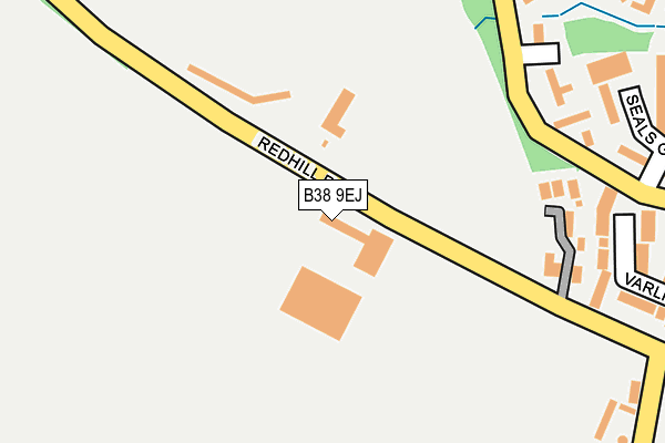
B38 9EJ is located in the Barnt Green & Hopwood electoral ward, within the local authority district of Bromsgrove and the English Parliamentary constituency of Bromsgrove. The Sub Integrated Care Board (ICB) Location is NHS Herefordshire and Worcestershire ICB - 18C and the police force is West Mercia. This postcode has been in use since January 2005.


GetTheData
Source: OS OpenMap – Local (Ordnance Survey)
Source: OS VectorMap District (Ordnance Survey)
Licence: Open Government Licence (requires attribution)
| Easting | 403587 |
| Northing | 276985 |
| Latitude | 52.390893 |
| Longitude | -1.948708 |
GetTheData
Source: Open Postcode Geo
Licence: Open Government Licence
| Country | England |
| Postcode District | B38 |
➜ See where B38 is on a map | |
GetTheData
Source: Land Registry Price Paid Data
Licence: Open Government Licence
Elevation or altitude of B38 9EJ as distance above sea level:
| Metres | Feet | |
|---|---|---|
| Elevation | 180m | 591ft |
Elevation is measured from the approximate centre of the postcode, to the nearest point on an OS contour line from OS Terrain 50, which has contour spacing of ten vertical metres.
➜ How high above sea level am I? Find the elevation of your current position using your device's GPS.
GetTheData
Source: Open Postcode Elevation
Licence: Open Government Licence
| Ward | Barnt Green & Hopwood |
| Constituency | Bromsgrove |
GetTheData
Source: ONS Postcode Database
Licence: Open Government Licence
| Wast Hill Playing Fields (Redhill Rd) | West Heath | 97m |
| Wast Hill Playing Fields (Redhill Rd) | West Heath | 102m |
| Pasture Walk (Longdales Rd) | Hawkesley | 265m |
| Bracken Way (Longdales Rd) | Hawkesley | 273m |
| Pasture Walk (Longdales Rd) | Hawkesley | 310m |
| Northfield Station | 2.3km |
| Longbridge Station | 2.3km |
| Kings Norton Station | 2.8km |
GetTheData
Source: NaPTAN
Licence: Open Government Licence
GetTheData
Source: ONS Postcode Database
Licence: Open Government Licence


➜ Get more ratings from the Food Standards Agency
GetTheData
Source: Food Standards Agency
Licence: FSA terms & conditions
| Last Collection | |||
|---|---|---|---|
| Location | Mon-Fri | Sat | Distance |
| Batheaston Close / Longdales R | 17:30 | 12:30 | 292m |
| Redditch Road / Redhill Road | 17:30 | 12:30 | 529m |
| 51 Sir Hiltons Road | 17:30 | 12:30 | 654m |
GetTheData
Source: Dracos
Licence: Creative Commons Attribution-ShareAlike
The below table lists the International Territorial Level (ITL) codes (formerly Nomenclature of Territorial Units for Statistics (NUTS) codes) and Local Administrative Units (LAU) codes for B38 9EJ:
| ITL 1 Code | Name |
|---|---|
| TLG | West Midlands (England) |
| ITL 2 Code | Name |
| TLG1 | Herefordshire, Worcestershire and Warwickshire |
| ITL 3 Code | Name |
| TLG12 | Worcestershire CC |
| LAU 1 Code | Name |
| E07000234 | Bromsgrove |
GetTheData
Source: ONS Postcode Directory
Licence: Open Government Licence
The below table lists the Census Output Area (OA), Lower Layer Super Output Area (LSOA), and Middle Layer Super Output Area (MSOA) for B38 9EJ:
| Code | Name | |
|---|---|---|
| OA | E00163844 | |
| LSOA | E01032122 | Bromsgrove 009A |
| MSOA | E02006704 | Bromsgrove 009 |
GetTheData
Source: ONS Postcode Directory
Licence: Open Government Licence
| B38 9EL | Redhill Road | 225m |
| B38 9UN | Longdales Road | 271m |
| B38 9UL | Batheaston Close | 292m |
| B38 9UW | Seals Green | 308m |
| B38 9UX | Varlins Way | 313m |
| B38 9UQ | Longdales Road | 357m |
| B38 9UH | Lime Kiln Close | 393m |
| B38 9DS | Redhill Road | 412m |
| B38 9UA | Forde Way Gardens | 412m |
| B38 9UG | Buckridge Close | 421m |
GetTheData
Source: Open Postcode Geo; Land Registry Price Paid Data
Licence: Open Government Licence