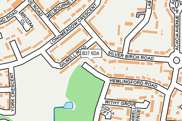
B37 6DA is located in the Kingshurst and Fordbridge electoral ward, within the metropolitan district of Solihull and the English Parliamentary constituency of Meriden. The Sub Integrated Care Board (ICB) Location is NHS Birmingham and Solihull ICB - 15E and the police force is West Midlands. This postcode has been in use since December 2000.


GetTheData
Source: OS OpenMap – Local (Ordnance Survey)
Source: OS VectorMap District (Ordnance Survey)
Licence: Open Government Licence (requires attribution)
| Easting | 416456 |
| Northing | 288595 |
| Latitude | 52.495018 |
| Longitude | -1.759047 |
GetTheData
Source: Open Postcode Geo
Licence: Open Government Licence
| Country | England |
| Postcode District | B37 |
➜ See where B37 is on a map ➜ Where is Birmingham? | |
GetTheData
Source: Land Registry Price Paid Data
Licence: Open Government Licence
Elevation or altitude of B37 6DA as distance above sea level:
| Metres | Feet | |
|---|---|---|
| Elevation | 90m | 295ft |
Elevation is measured from the approximate centre of the postcode, to the nearest point on an OS contour line from OS Terrain 50, which has contour spacing of ten vertical metres.
➜ How high above sea level am I? Find the elevation of your current position using your device's GPS.
GetTheData
Source: Open Postcode Elevation
Licence: Open Government Licence
| Ward | Kingshurst And Fordbridge |
| Constituency | Meriden |
GetTheData
Source: ONS Postcode Database
Licence: Open Government Licence
| Gilwell Road (Silver Birch Rd) | Kingshurst | 52m |
| Gilwell Road (Silver Birch Rd) | Kingshurst | 74m |
| Berrowside Rd (Longmeadow Cres) | Shard End | 130m |
| Berrowside Rd (Longmeadow Cres) | Shard End | 133m |
| Kingshurst Way (Silver Birch Rd) | Kingshurst | 260m |
| Lea Hall Station | 2.4km |
| Water Orton Station | 2.8km |
| Marston Green Station | 3.1km |
GetTheData
Source: NaPTAN
Licence: Open Government Licence
| Percentage of properties with Next Generation Access | 100.0% |
| Percentage of properties with Superfast Broadband | 100.0% |
| Percentage of properties with Ultrafast Broadband | 0.0% |
| Percentage of properties with Full Fibre Broadband | 0.0% |
Superfast Broadband is between 30Mbps and 300Mbps
Ultrafast Broadband is > 300Mbps
| Percentage of properties unable to receive 2Mbps | 0.0% |
| Percentage of properties unable to receive 5Mbps | 0.0% |
| Percentage of properties unable to receive 10Mbps | 0.0% |
| Percentage of properties unable to receive 30Mbps | 0.0% |
GetTheData
Source: Ofcom
Licence: Ofcom Terms of Use (requires attribution)
GetTheData
Source: ONS Postcode Database
Licence: Open Government Licence


➜ Get more ratings from the Food Standards Agency
GetTheData
Source: Food Standards Agency
Licence: FSA terms & conditions
| Last Collection | |||
|---|---|---|---|
| Location | Mon-Fri | Sat | Distance |
| Shard End Post Office | 17:30 | 11:30 | 1,175m |
| Leycroftavenue | 18:30 | 11:30 | 1,299m |
| Auckland Drive/Lundy View | 17:30 | 12:30 | 1,473m |
GetTheData
Source: Dracos
Licence: Creative Commons Attribution-ShareAlike
The below table lists the International Territorial Level (ITL) codes (formerly Nomenclature of Territorial Units for Statistics (NUTS) codes) and Local Administrative Units (LAU) codes for B37 6DA:
| ITL 1 Code | Name |
|---|---|
| TLG | West Midlands (England) |
| ITL 2 Code | Name |
| TLG3 | West Midlands |
| ITL 3 Code | Name |
| TLG32 | Solihull |
| LAU 1 Code | Name |
| E08000029 | Solihull |
GetTheData
Source: ONS Postcode Directory
Licence: Open Government Licence
The below table lists the Census Output Area (OA), Lower Layer Super Output Area (LSOA), and Middle Layer Super Output Area (MSOA) for B37 6DA:
| Code | Name | |
|---|---|---|
| OA | E00051308 | |
| LSOA | E01010148 | Solihull 005C |
| MSOA | E02002085 | Solihull 005 |
GetTheData
Source: ONS Postcode Directory
Licence: Open Government Licence
| B34 7NN | Gilwell Road | 74m |
| B34 7NL | Longmeadow Crescent | 106m |
| B34 7NP | Rowington Road | 109m |
| B37 6DH | Hemlingford Road | 116m |
| B37 6AS | Silver Birch Road | 141m |
| B37 6AH | Silver Birch Road | 157m |
| B37 6DJ | Hemlingford Road | 164m |
| B37 6DL | Yorks Wood Drive | 181m |
| B37 6DN | Withy Grove | 187m |
| B34 7NG | Longmeadow Crescent | 188m |
GetTheData
Source: Open Postcode Geo; Land Registry Price Paid Data
Licence: Open Government Licence