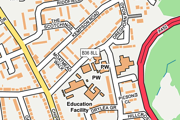
B36 8LL is located in the Bromford & Hodge Hill electoral ward, within the metropolitan district of Birmingham and the English Parliamentary constituency of Birmingham, Hodge Hill. The Sub Integrated Care Board (ICB) Location is NHS Birmingham and Solihull ICB - 15E and the police force is West Midlands. This postcode has been in use since January 1980.


GetTheData
Source: OS OpenMap – Local (Ordnance Survey)
Source: OS VectorMap District (Ordnance Survey)
Licence: Open Government Licence (requires attribution)
| Easting | 413529 |
| Northing | 289692 |
| Latitude | 52.504975 |
| Longitude | -1.802107 |
GetTheData
Source: Open Postcode Geo
Licence: Open Government Licence
| Country | England |
| Postcode District | B36 |
➜ See where B36 is on a map ➜ Where is Birmingham? | |
GetTheData
Source: Land Registry Price Paid Data
Licence: Open Government Licence
Elevation or altitude of B36 8LL as distance above sea level:
| Metres | Feet | |
|---|---|---|
| Elevation | 90m | 295ft |
Elevation is measured from the approximate centre of the postcode, to the nearest point on an OS contour line from OS Terrain 50, which has contour spacing of ten vertical metres.
➜ How high above sea level am I? Find the elevation of your current position using your device's GPS.
GetTheData
Source: Open Postcode Elevation
Licence: Open Government Licence
| Ward | Bromford & Hodge Hill |
| Constituency | Birmingham, Hodge Hill |
GetTheData
Source: ONS Postcode Database
Licence: Open Government Licence
| Kempson Rd (Chipperfield Rd) | Bromford | 216m |
| Millington Rd (Chipperfield Rd) | Hodgehill | 235m |
| Collingbourne Avenue (Chipperfield Rd) | Bromford | 250m |
| Collingbourne Avenue (Chipperfield Rd) | Bromford | 260m |
| Millington Rd (Chipperfield Rd) | Hodgehill | 264m |
| Stechford Station | 2.3km |
| Lea Hall Station | 2.9km |
| Gravelly Hill Station | 3.6km |
GetTheData
Source: NaPTAN
Licence: Open Government Licence
| Percentage of properties with Next Generation Access | 100.0% |
| Percentage of properties with Superfast Broadband | 100.0% |
| Percentage of properties with Ultrafast Broadband | 0.0% |
| Percentage of properties with Full Fibre Broadband | 0.0% |
Superfast Broadband is between 30Mbps and 300Mbps
Ultrafast Broadband is > 300Mbps
| Percentage of properties unable to receive 2Mbps | 0.0% |
| Percentage of properties unable to receive 5Mbps | 0.0% |
| Percentage of properties unable to receive 10Mbps | 0.0% |
| Percentage of properties unable to receive 30Mbps | 0.0% |
GetTheData
Source: Ofcom
Licence: Ofcom Terms of Use (requires attribution)
GetTheData
Source: ONS Postcode Database
Licence: Open Government Licence


➜ Get more ratings from the Food Standards Agency
GetTheData
Source: Food Standards Agency
Licence: FSA terms & conditions
| Last Collection | |||
|---|---|---|---|
| Location | Mon-Fri | Sat | Distance |
| Bromford Road Collingbourne Road | 17:30 | 12:30 | 718m |
| Castle Bromwich Del Office | 17:30 | 12:30 | 760m |
| Ventnor Avenue / Coleshill Road | 17:30 | 12:30 | 968m |
GetTheData
Source: Dracos
Licence: Creative Commons Attribution-ShareAlike
The below table lists the International Territorial Level (ITL) codes (formerly Nomenclature of Territorial Units for Statistics (NUTS) codes) and Local Administrative Units (LAU) codes for B36 8LL:
| ITL 1 Code | Name |
|---|---|
| TLG | West Midlands (England) |
| ITL 2 Code | Name |
| TLG3 | West Midlands |
| ITL 3 Code | Name |
| TLG31 | Birmingham |
| LAU 1 Code | Name |
| E08000025 | Birmingham |
GetTheData
Source: ONS Postcode Directory
Licence: Open Government Licence
The below table lists the Census Output Area (OA), Lower Layer Super Output Area (LSOA), and Middle Layer Super Output Area (MSOA) for B36 8LL:
| Code | Name | |
|---|---|---|
| OA | E00175784 | |
| LSOA | E01009083 | Birmingham 038D |
| MSOA | E02001864 | Birmingham 038 |
GetTheData
Source: ONS Postcode Directory
Licence: Open Government Licence
| B36 8LT | Moatmead Walk | 76m |
| B36 8LN | Dreghorn Road | 87m |
| B36 8LS | Kempson Road | 97m |
| B36 8LY | Shawsdale Road | 149m |
| B36 8LR | Kempson Road | 156m |
| B36 8LU | The Scotchings | 165m |
| B36 8LX | Dreghorn Road | 165m |
| B36 8NP | Crofton Gardens | 168m |
| B36 8BX | Chipperfield Road | 175m |
| B36 8NX | Riddfield Road | 178m |
GetTheData
Source: Open Postcode Geo; Land Registry Price Paid Data
Licence: Open Government Licence