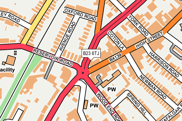
B23 6TJ lies on Sutton New Road in Birmingham. B23 6TJ is located in the Erdington electoral ward, within the metropolitan district of Birmingham and the English Parliamentary constituency of Birmingham, Erdington. The Sub Integrated Care Board (ICB) Location is NHS Birmingham and Solihull ICB - 15E and the police force is West Midlands. This postcode has been in use since January 1980.


GetTheData
Source: OS OpenMap – Local (Ordnance Survey)
Source: OS VectorMap District (Ordnance Survey)
Licence: Open Government Licence (requires attribution)
| Easting | 410689 |
| Northing | 291594 |
| Latitude | 52.522136 |
| Longitude | -1.843887 |
GetTheData
Source: Open Postcode Geo
Licence: Open Government Licence
| Street | Sutton New Road |
| Town/City | Birmingham |
| Country | England |
| Postcode District | B23 |
➜ See where B23 is on a map ➜ Where is Birmingham? | |
GetTheData
Source: Land Registry Price Paid Data
Licence: Open Government Licence
Elevation or altitude of B23 6TJ as distance above sea level:
| Metres | Feet | |
|---|---|---|
| Elevation | 120m | 394ft |
Elevation is measured from the approximate centre of the postcode, to the nearest point on an OS contour line from OS Terrain 50, which has contour spacing of ten vertical metres.
➜ How high above sea level am I? Find the elevation of your current position using your device's GPS.
GetTheData
Source: Open Postcode Elevation
Licence: Open Government Licence
| Ward | Erdington |
| Constituency | Birmingham, Erdington |
GetTheData
Source: ONS Postcode Database
Licence: Open Government Licence
| Six Ways (Summer Rd) | Erdington | 43m |
| Six Ways (Summer Rd) | Erdington | 51m |
| Six Ways Erdington (Wood End Rd) | Erdington | 75m |
| Six Ways Island (Sutton New Rd) | Erdington | 126m |
| Six Ways Island (Sutton New Rd) | Erdington | 137m |
| Erdington Station | 0.7km |
| Gravelly Hill Station | 1km |
| Chester Road Station | 1.7km |
GetTheData
Source: NaPTAN
Licence: Open Government Licence
GetTheData
Source: ONS Postcode Database
Licence: Open Government Licence


➜ Get more ratings from the Food Standards Agency
GetTheData
Source: Food Standards Agency
Licence: FSA terms & conditions
| Last Collection | |||
|---|---|---|---|
| Location | Mon-Fri | Sat | Distance |
| Wood End Lane | 17:30 | 12:15 | 120m |
| South Road | 17:15 | 12:15 | 285m |
| High St / Barnabas Road | 17:45 | 12:15 | 361m |
GetTheData
Source: Dracos
Licence: Creative Commons Attribution-ShareAlike
The below table lists the International Territorial Level (ITL) codes (formerly Nomenclature of Territorial Units for Statistics (NUTS) codes) and Local Administrative Units (LAU) codes for B23 6TJ:
| ITL 1 Code | Name |
|---|---|
| TLG | West Midlands (England) |
| ITL 2 Code | Name |
| TLG3 | West Midlands |
| ITL 3 Code | Name |
| TLG31 | Birmingham |
| LAU 1 Code | Name |
| E08000025 | Birmingham |
GetTheData
Source: ONS Postcode Directory
Licence: Open Government Licence
The below table lists the Census Output Area (OA), Lower Layer Super Output Area (LSOA), and Middle Layer Super Output Area (MSOA) for B23 6TJ:
| Code | Name | |
|---|---|---|
| OA | E00045681 | |
| LSOA | E01009007 | Birmingham 023D |
| MSOA | E02001849 | Birmingham 023 |
GetTheData
Source: ONS Postcode Directory
Licence: Open Government Licence
| B23 6SR | High Street | 46m |
| B23 6DA | Reservoir Road | 63m |
| B23 6XA | Summer Road | 84m |
| B23 6DS | Reservoir Road | 94m |
| B23 6TP | Coton Lane | 97m |
| B23 6UY | Avenue Road | 137m |
| B24 8AA | Wood End Road | 153m |
| B23 6SS | High Street | 153m |
| B23 6UX | Oxford Road | 169m |
| B24 8AD | Wood End Road | 180m |
GetTheData
Source: Open Postcode Geo; Land Registry Price Paid Data
Licence: Open Government Licence