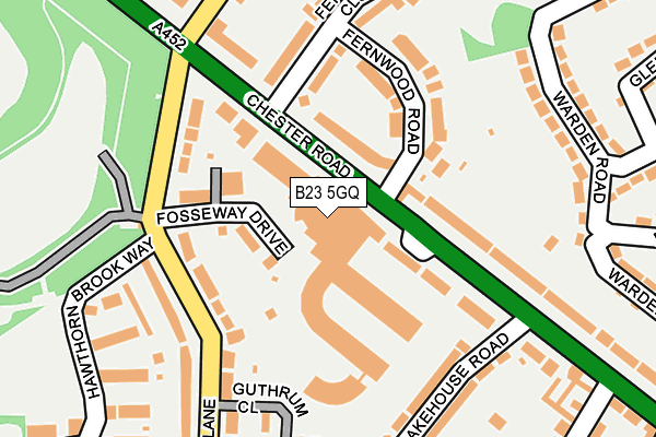
B23 5GQ lies on Fosseway Drive in Birmingham. B23 5GQ is located in the Erdington electoral ward, within the metropolitan district of Birmingham and the English Parliamentary constituency of Birmingham, Erdington. The Sub Integrated Care Board (ICB) Location is NHS Birmingham and Solihull ICB - 15E and the police force is West Midlands. This postcode has been in use since April 2010.


GetTheData
Source: OS OpenMap – Local (Ordnance Survey)
Source: OS VectorMap District (Ordnance Survey)
Licence: Open Government Licence (requires attribution)
| Easting | 410389 |
| Northing | 293832 |
| Latitude | 52.542246 |
| Longitude | -1.848246 |
GetTheData
Source: Open Postcode Geo
Licence: Open Government Licence
| Street | Fosseway Drive |
| Town/City | Birmingham |
| Country | England |
| Postcode District | B23 |
➜ See where B23 is on a map ➜ Where is Royal Sutton Coldfield? | |
GetTheData
Source: Land Registry Price Paid Data
Licence: Open Government Licence
Elevation or altitude of B23 5GQ as distance above sea level:
| Metres | Feet | |
|---|---|---|
| Elevation | 130m | 427ft |
Elevation is measured from the approximate centre of the postcode, to the nearest point on an OS contour line from OS Terrain 50, which has contour spacing of ten vertical metres.
➜ How high above sea level am I? Find the elevation of your current position using your device's GPS.
GetTheData
Source: Open Postcode Elevation
Licence: Open Government Licence
| Ward | Erdington |
| Constituency | Birmingham, Erdington |
GetTheData
Source: ONS Postcode Database
Licence: Open Government Licence
| Fernwood Rd (Chester Rd) | Short Heath | 32m |
| The Greyhound (Court Lane) | Short Heath | 144m |
| Lakehouse Rd (Chester Rd) | Short Heath | 152m |
| Fosseway Drive (Court Lane) | New Oscott | 157m |
| Fosseway Drive (Court Lane) | New Oscott | 181m |
| Wylde Green Station | 1.2km |
| Chester Road Station | 1.3km |
| Erdington Station | 1.7km |
GetTheData
Source: NaPTAN
Licence: Open Government Licence
| Percentage of properties with Next Generation Access | 0.0% |
| Percentage of properties with Superfast Broadband | 0.0% |
| Percentage of properties with Ultrafast Broadband | 0.0% |
| Percentage of properties with Full Fibre Broadband | 0.0% |
Superfast Broadband is between 30Mbps and 300Mbps
Ultrafast Broadband is > 300Mbps
| Median download speed | 3.8Mbps |
| Average download speed | 3.7Mbps |
| Maximum download speed | 6.46Mbps |
| Median upload speed | 0.6Mbps |
| Average upload speed | 0.6Mbps |
| Maximum upload speed | 0.90Mbps |
| Percentage of properties unable to receive 2Mbps | 0.0% |
| Percentage of properties unable to receive 5Mbps | 0.0% |
| Percentage of properties unable to receive 10Mbps | 100.0% |
| Percentage of properties unable to receive 30Mbps | 100.0% |
GetTheData
Source: Ofcom
Licence: Ofcom Terms of Use (requires attribution)
GetTheData
Source: ONS Postcode Database
Licence: Open Government Licence


➜ Get more ratings from the Food Standards Agency
GetTheData
Source: Food Standards Agency
Licence: FSA terms & conditions
| Last Collection | |||
|---|---|---|---|
| Location | Mon-Fri | Sat | Distance |
| Fosseway Drive | 17:30 | 12:30 | 63m |
| Antrobus Road / Chester Road | 17:30 | 12:00 | 218m |
| Warden Road / Colfield Road | 17:15 | 12:00 | 242m |
GetTheData
Source: Dracos
Licence: Creative Commons Attribution-ShareAlike
The below table lists the International Territorial Level (ITL) codes (formerly Nomenclature of Territorial Units for Statistics (NUTS) codes) and Local Administrative Units (LAU) codes for B23 5GQ:
| ITL 1 Code | Name |
|---|---|
| TLG | West Midlands (England) |
| ITL 2 Code | Name |
| TLG3 | West Midlands |
| ITL 3 Code | Name |
| TLG31 | Birmingham |
| LAU 1 Code | Name |
| E08000025 | Birmingham |
GetTheData
Source: ONS Postcode Directory
Licence: Open Government Licence
The below table lists the Census Output Area (OA), Lower Layer Super Output Area (LSOA), and Middle Layer Super Output Area (MSOA) for B23 5GQ:
| Code | Name | |
|---|---|---|
| OA | E00175703 | |
| LSOA | E01009458 | Birmingham 018D |
| MSOA | E02001844 | Birmingham 018 |
GetTheData
Source: ONS Postcode Directory
Licence: Open Government Licence
| B23 5GH | Fosseway Drive | 0m |
| B23 5GJ | Fosseway Drive | 0m |
| B23 5GL | Fosseway Drive | 0m |
| B23 5GN | Fosseway Drive | 0m |
| B23 5GP | Fosseway Drive | 0m |
| B23 5GR | Fosseway Drive | 0m |
| B73 5BJ | Chester Road | 71m |
| B23 5JY | 75m | |
| B73 5BZ | Chester Road | 85m |
| B23 5LD | Fosseway Drive | 102m |
GetTheData
Source: Open Postcode Geo; Land Registry Price Paid Data
Licence: Open Government Licence