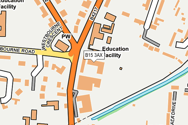
B15 3AX is located in the Edgbaston electoral ward, within the metropolitan district of Birmingham and the English Parliamentary constituency of Birmingham, Edgbaston. The Sub Integrated Care Board (ICB) Location is NHS Birmingham and Solihull ICB - 15E and the police force is West Midlands. This postcode has been in use since November 2016.


GetTheData
Source: OS OpenMap – Local (Ordnance Survey)
Source: OS VectorMap District (Ordnance Survey)
Licence: Open Government Licence (requires attribution)
| Easting | 405465 |
| Northing | 285479 |
| Latitude | 52.467239 |
| Longitude | -1.920979 |
GetTheData
Source: Open Postcode Geo
Licence: Open Government Licence
| Country | England |
| Postcode District | B15 |
➜ See where B15 is on a map ➜ Where is Birmingham? | |
GetTheData
Source: Land Registry Price Paid Data
Licence: Open Government Licence
Elevation or altitude of B15 3AX as distance above sea level:
| Metres | Feet | |
|---|---|---|
| Elevation | 150m | 492ft |
Elevation is measured from the approximate centre of the postcode, to the nearest point on an OS contour line from OS Terrain 50, which has contour spacing of ten vertical metres.
➜ How high above sea level am I? Find the elevation of your current position using your device's GPS.
GetTheData
Source: Open Postcode Elevation
Licence: Open Government Licence
| Ward | Edgbaston |
| Constituency | Birmingham, Edgbaston |
GetTheData
Source: ONS Postcode Database
Licence: Open Government Licence
| Highfield Rd (Calthorpe Rd) | Five Ways | 119m |
| St Georges Church (Westbourne Cres) | Botanical Gardens | 163m |
| Carpenter Rd (Church Rd) | Edgbaston | 187m |
| St George's Church (Westbourne Rd) | Botanical Gardens | 240m |
| Carpenter Rd (Church Rd) | Edgbaston | 278m |
| Grand Central New Street (Midland Metro Stop) (Stephenson Street) | Birmingham | 1,943m |
| Five Ways Station | 0.7km |
| Birmingham New Street Station | 1.8km |
| University Station | 2.1km |
GetTheData
Source: NaPTAN
Licence: Open Government Licence
| Percentage of properties with Next Generation Access | 0.0% |
| Percentage of properties with Superfast Broadband | 0.0% |
| Percentage of properties with Ultrafast Broadband | 0.0% |
| Percentage of properties with Full Fibre Broadband | 0.0% |
Superfast Broadband is between 30Mbps and 300Mbps
Ultrafast Broadband is > 300Mbps
| Median download speed | 9.7Mbps |
| Average download speed | 8.3Mbps |
| Maximum download speed | 12.18Mbps |
| Median upload speed | 1.0Mbps |
| Average upload speed | 1.0Mbps |
| Maximum upload speed | 1.09Mbps |
| Percentage of properties unable to receive 2Mbps | 0.0% |
| Percentage of properties unable to receive 5Mbps | 0.0% |
| Percentage of properties unable to receive 10Mbps | 0.0% |
| Percentage of properties unable to receive 30Mbps | 100.0% |
GetTheData
Source: Ofcom
Licence: Ofcom Terms of Use (requires attribution)
GetTheData
Source: ONS Postcode Database
Licence: Open Government Licence


➜ Get more ratings from the Food Standards Agency
GetTheData
Source: Food Standards Agency
Licence: FSA terms & conditions
| Last Collection | |||
|---|---|---|---|
| Location | Mon-Fri | Sat | Distance |
| Calthorpe Road | 18:30 | 12:30 | 165m |
| Ampton Road Near Carpenters Ro | 17:30 | 12:30 | 283m |
| Greenfield Crescent/ Calthorpe | 18:30 | 12:30 | 287m |
GetTheData
Source: Dracos
Licence: Creative Commons Attribution-ShareAlike
The below table lists the International Territorial Level (ITL) codes (formerly Nomenclature of Territorial Units for Statistics (NUTS) codes) and Local Administrative Units (LAU) codes for B15 3AX:
| ITL 1 Code | Name |
|---|---|
| TLG | West Midlands (England) |
| ITL 2 Code | Name |
| TLG3 | West Midlands |
| ITL 3 Code | Name |
| TLG31 | Birmingham |
| LAU 1 Code | Name |
| E08000025 | Birmingham |
GetTheData
Source: ONS Postcode Directory
Licence: Open Government Licence
The below table lists the Census Output Area (OA), Lower Layer Super Output Area (LSOA), and Middle Layer Super Output Area (MSOA) for B15 3AX:
| Code | Name | |
|---|---|---|
| OA | E00175781 | |
| LSOA | E01033631 | Birmingham 079F |
| MSOA | E02001905 | Birmingham 079 |
GetTheData
Source: ONS Postcode Directory
Licence: Open Government Licence
| B15 3SH | Church Road | 81m |
| B15 3TJ | Westbourne Gardens | 163m |
| B15 1JB | The Paddocks | 187m |
| B15 3SJ | Church Road | 187m |
| B15 2JT | Carpenter Road | 222m |
| B15 3TH | Westbourne Road | 227m |
| B15 2JU | Carpenter Road | 246m |
| B15 1RP | Calthorpe Road | 256m |
| B15 2JR | Cala Drive | 269m |
| B15 1JN | Frederick Road | 278m |
GetTheData
Source: Open Postcode Geo; Land Registry Price Paid Data
Licence: Open Government Licence