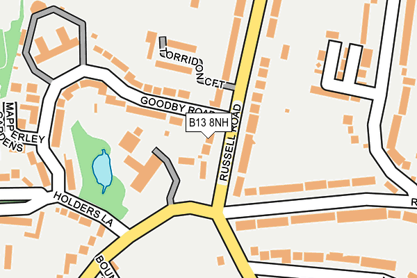
B13 8NH lies on Russell Road in Moseley, Birmingham. B13 8NH is located in the Moseley electoral ward, within the metropolitan district of Birmingham and the English Parliamentary constituency of Birmingham, Hall Green. The Sub Integrated Care Board (ICB) Location is NHS Birmingham and Solihull ICB - 15E and the police force is West Midlands. This postcode has been in use since January 1980.


GetTheData
Source: OS OpenMap – Local (Ordnance Survey)
Source: OS VectorMap District (Ordnance Survey)
Licence: Open Government Licence (requires attribution)
| Easting | 406771 |
| Northing | 283051 |
| Latitude | 52.445397 |
| Longitude | -1.901803 |
GetTheData
Source: Open Postcode Geo
Licence: Open Government Licence
| Street | Russell Road |
| Locality | Moseley |
| Town/City | Birmingham |
| Country | England |
| Postcode District | B13 |
➜ See where B13 is on a map ➜ Where is Birmingham? | |
GetTheData
Source: Land Registry Price Paid Data
Licence: Open Government Licence
Elevation or altitude of B13 8NH as distance above sea level:
| Metres | Feet | |
|---|---|---|
| Elevation | 140m | 459ft |
Elevation is measured from the approximate centre of the postcode, to the nearest point on an OS contour line from OS Terrain 50, which has contour spacing of ten vertical metres.
➜ How high above sea level am I? Find the elevation of your current position using your device's GPS.
GetTheData
Source: Open Postcode Elevation
Licence: Open Government Licence
| Ward | Moseley |
| Constituency | Birmingham, Hall Green |
GetTheData
Source: ONS Postcode Database
Licence: Open Government Licence
78, RUSSELL ROAD, MOSELEY, BIRMINGHAM, B13 8NH 2018 23 AUG £720,000 |
76, RUSSELL ROAD, MOSELEY, BIRMINGHAM, B13 8NH 2009 27 AUG £499,500 |
80, RUSSELL ROAD, MOSELEY, BIRMINGHAM, B13 8NH 2008 12 DEC £440,000 |
GetTheData
Source: HM Land Registry Price Paid Data
Licence: Contains HM Land Registry data © Crown copyright and database right 2025. This data is licensed under the Open Government Licence v3.0.
| Pitmaston (Moor Green Lane) | Moor Green | 73m |
| Pitmaston (Moor Green Lane) | Moor Green | 90m |
| Amesbury Rd (Salisbury Rd) | Moseley | 567m |
| Amesbury Rd (Salisbury Rd) | Moseley | 574m |
| Moor Green Lane (Alcester Rd) | Moseley | 708m |
| Selly Oak Station | 2.3km |
| University Station | 2.5km |
| Bournville Station | 2.6km |
GetTheData
Source: NaPTAN
Licence: Open Government Licence
| Percentage of properties with Next Generation Access | 100.0% |
| Percentage of properties with Superfast Broadband | 100.0% |
| Percentage of properties with Ultrafast Broadband | 100.0% |
| Percentage of properties with Full Fibre Broadband | 0.0% |
Superfast Broadband is between 30Mbps and 300Mbps
Ultrafast Broadband is > 300Mbps
| Percentage of properties unable to receive 2Mbps | 0.0% |
| Percentage of properties unable to receive 5Mbps | 0.0% |
| Percentage of properties unable to receive 10Mbps | 0.0% |
| Percentage of properties unable to receive 30Mbps | 0.0% |
GetTheData
Source: Ofcom
Licence: Ofcom Terms of Use (requires attribution)
GetTheData
Source: ONS Postcode Database
Licence: Open Government Licence


➜ Get more ratings from the Food Standards Agency
GetTheData
Source: Food Standards Agency
Licence: FSA terms & conditions
| Last Collection | |||
|---|---|---|---|
| Location | Mon-Fri | Sat | Distance |
| Moor Green Lane / Reddings Roa | 17:45 | 12:30 | 135m |
| Goodbye Road Opposite Block Of F | 18:00 | 12:30 | 224m |
| Salisbury Road / Amesbury Road | 18:00 | 12:30 | 551m |
GetTheData
Source: Dracos
Licence: Creative Commons Attribution-ShareAlike
The below table lists the International Territorial Level (ITL) codes (formerly Nomenclature of Territorial Units for Statistics (NUTS) codes) and Local Administrative Units (LAU) codes for B13 8NH:
| ITL 1 Code | Name |
|---|---|
| TLG | West Midlands (England) |
| ITL 2 Code | Name |
| TLG3 | West Midlands |
| ITL 3 Code | Name |
| TLG31 | Birmingham |
| LAU 1 Code | Name |
| E08000025 | Birmingham |
GetTheData
Source: ONS Postcode Directory
Licence: Open Government Licence
The below table lists the Census Output Area (OA), Lower Layer Super Output Area (LSOA), and Middle Layer Super Output Area (MSOA) for B13 8NH:
| Code | Name | |
|---|---|---|
| OA | E00046571 | |
| LSOA | E01009183 | Birmingham 088C |
| MSOA | E02001914 | Birmingham 088 |
GetTheData
Source: ONS Postcode Directory
Licence: Open Government Licence
| B13 8JN | Moor Green Lane | 114m |
| B13 8RR | Russell Road | 153m |
| B13 8LR | Reddings Road | 154m |
| B13 8RG | Torridon Croft | 161m |
| B13 8RH | Goodby Road | 170m |
| B13 8LP | Reddings Road | 203m |
| B13 8NS | Moor Green Lane | 213m |
| B13 8NJ | Goodby Road | 218m |
| B13 8RF | Russell Road | 229m |
| B13 8LS | Moorcroft Road | 234m |
GetTheData
Source: Open Postcode Geo; Land Registry Price Paid Data
Licence: Open Government Licence