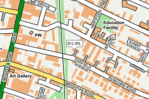
B12 8RL lies on Ivy Avenue in Birmingham. B12 8RL is located in the Sparkbrook & Balsall Heath East electoral ward, within the metropolitan district of Birmingham and the English Parliamentary constituency of Birmingham, Hall Green. The Sub Integrated Care Board (ICB) Location is NHS Birmingham and Solihull ICB - 15E and the police force is West Midlands. This postcode has been in use since January 1980.


GetTheData
Source: OS OpenMap – Local (Ordnance Survey)
Source: OS VectorMap District (Ordnance Survey)
Licence: Open Government Licence (requires attribution)
| Easting | 408078 |
| Northing | 284187 |
| Latitude | 52.455577 |
| Longitude | -1.882552 |
GetTheData
Source: Open Postcode Geo
Licence: Open Government Licence
| Street | Ivy Avenue |
| Town/City | Birmingham |
| Country | England |
| Postcode District | B12 |
➜ See where B12 is on a map ➜ Where is Birmingham? | |
GetTheData
Source: Land Registry Price Paid Data
Licence: Open Government Licence
Elevation or altitude of B12 8RL as distance above sea level:
| Metres | Feet | |
|---|---|---|
| Elevation | 130m | 427ft |
Elevation is measured from the approximate centre of the postcode, to the nearest point on an OS contour line from OS Terrain 50, which has contour spacing of ten vertical metres.
➜ How high above sea level am I? Find the elevation of your current position using your device's GPS.
GetTheData
Source: Open Postcode Elevation
Licence: Open Government Licence
| Ward | Sparkbrook & Balsall Heath East |
| Constituency | Birmingham, Hall Green |
GetTheData
Source: ONS Postcode Database
Licence: Open Government Licence
| Edward Rd (Moseley Rd) | Balsall Heath | 244m |
| Edward Rd (Moseley Rd) | Balsall Heath | 297m |
| Trafalgar Rd (Moseley Rd) | Balsall Heath | 321m |
| Trafalgar Rd (Moseley Rd) | Balsall Heath | 348m |
| Balsall Heath Park (Taunton Rd) | Balsall Heath | 386m |
| Small Heath Station | 1.8km |
| Bordesley Station | 1.8km |
| Five Ways Station | 2.7km |
GetTheData
Source: NaPTAN
Licence: Open Government Licence
| Percentage of properties with Next Generation Access | 100.0% |
| Percentage of properties with Superfast Broadband | 100.0% |
| Percentage of properties with Ultrafast Broadband | 0.0% |
| Percentage of properties with Full Fibre Broadband | 0.0% |
Superfast Broadband is between 30Mbps and 300Mbps
Ultrafast Broadband is > 300Mbps
| Percentage of properties unable to receive 2Mbps | 0.0% |
| Percentage of properties unable to receive 5Mbps | 0.0% |
| Percentage of properties unable to receive 10Mbps | 0.0% |
| Percentage of properties unable to receive 30Mbps | 0.0% |
GetTheData
Source: Ofcom
Licence: Ofcom Terms of Use (requires attribution)
Estimated total energy consumption in B12 8RL by fuel type, 2015.
| Consumption (kWh) | 81,508 |
|---|---|
| Meter count | 6 |
| Mean (kWh/meter) | 13,585 |
| Median (kWh/meter) | 14,276 |
| Consumption (kWh) | 15,508 |
|---|---|
| Meter count | 7 |
| Mean (kWh/meter) | 2,215 |
| Median (kWh/meter) | 1,724 |
GetTheData
Source: Postcode level gas estimates: 2015 (experimental)
Source: Postcode level electricity estimates: 2015 (experimental)
Licence: Open Government Licence
GetTheData
Source: ONS Postcode Database
Licence: Open Government Licence


➜ Get more ratings from the Food Standards Agency
GetTheData
Source: Food Standards Agency
Licence: FSA terms & conditions
| Last Collection | |||
|---|---|---|---|
| Location | Mon-Fri | Sat | Distance |
| Brighton Road Opposite Kingswood | 18:15 | 12:30 | 183m |
| Brighton Road Post Office | 17:30 | 12:30 | 275m |
| Hertford St / St Pauls Road | 17:45 | 12:30 | 288m |
GetTheData
Source: Dracos
Licence: Creative Commons Attribution-ShareAlike
The below table lists the International Territorial Level (ITL) codes (formerly Nomenclature of Territorial Units for Statistics (NUTS) codes) and Local Administrative Units (LAU) codes for B12 8RL:
| ITL 1 Code | Name |
|---|---|
| TLG | West Midlands (England) |
| ITL 2 Code | Name |
| TLG3 | West Midlands |
| ITL 3 Code | Name |
| TLG31 | Birmingham |
| LAU 1 Code | Name |
| E08000025 | Birmingham |
GetTheData
Source: ONS Postcode Directory
Licence: Open Government Licence
The below table lists the Census Output Area (OA), Lower Layer Super Output Area (LSOA), and Middle Layer Super Output Area (MSOA) for B12 8RL:
| Code | Name | |
|---|---|---|
| OA | E00047516 | |
| LSOA | E01009377 | Birmingham 083C |
| MSOA | E02001909 | Birmingham 083 |
GetTheData
Source: ONS Postcode Directory
Licence: Open Government Licence
| B12 8RQ | Runcorn Road | 48m |
| B12 8SR | Clifton Road | 61m |
| B12 8RJ | Holly Avenue | 64m |
| B12 8QP | Runcorn Road | 77m |
| B12 8QR | Fir Avenue | 88m |
| B12 8RH | Lilac Avenue | 94m |
| B12 8QS | Beech Avenue | 120m |
| B12 8QN | Brighton Road | 123m |
| B12 8RG | May Avenue | 141m |
| B12 8PU | Brighton Road | 157m |
GetTheData
Source: Open Postcode Geo; Land Registry Price Paid Data
Licence: Open Government Licence