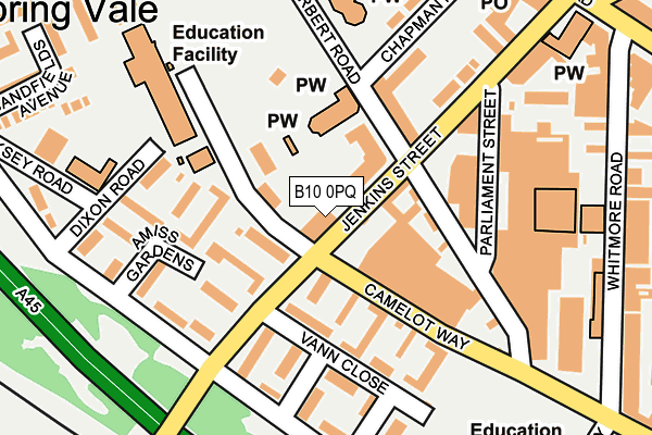
B10 0PQ is located in the Bordesley Green electoral ward, within the metropolitan district of Birmingham and the English Parliamentary constituency of Birmingham, Ladywood. The Sub Integrated Care Board (ICB) Location is NHS Birmingham and Solihull ICB - 15E and the police force is West Midlands. This postcode has been in use since October 1985.


GetTheData
Source: OS OpenMap – Local (Ordnance Survey)
Source: OS VectorMap District (Ordnance Survey)
Licence: Open Government Licence (requires attribution)
| Easting | 409158 |
| Northing | 285765 |
| Latitude | 52.469761 |
| Longitude | -1.866611 |
GetTheData
Source: Open Postcode Geo
Licence: Open Government Licence
| Country | England |
| Postcode District | B10 |
➜ See where B10 is on a map ➜ Where is Birmingham? | |
GetTheData
Source: Land Registry Price Paid Data
Licence: Open Government Licence
Elevation or altitude of B10 0PQ as distance above sea level:
| Metres | Feet | |
|---|---|---|
| Elevation | 130m | 427ft |
Elevation is measured from the approximate centre of the postcode, to the nearest point on an OS contour line from OS Terrain 50, which has contour spacing of ten vertical metres.
➜ How high above sea level am I? Find the elevation of your current position using your device's GPS.
GetTheData
Source: Open Postcode Elevation
Licence: Open Government Licence
| Ward | Bordesley Green |
| Constituency | Birmingham, Ladywood |
GetTheData
Source: ONS Postcode Database
Licence: Open Government Licence
| Cooksey Rd (Jenkins St) | Bordesley | 84m |
| Amiss Gardens (Bolton Rd) | Bordesley | 228m |
| Herbert Rd (Camelot Way) | Small Heath | 263m |
| Herbert Rd (Camelot Way) | Small Heath | 267m |
| Green Lane (Coventry Rd) | Bordesley | 290m |
| Bordesley Station | 0.8km |
| Small Heath Station | 0.8km |
| Adderley Park Station | 1.7km |
GetTheData
Source: NaPTAN
Licence: Open Government Licence
| Percentage of properties with Next Generation Access | 100.0% |
| Percentage of properties with Superfast Broadband | 100.0% |
| Percentage of properties with Ultrafast Broadband | 0.0% |
| Percentage of properties with Full Fibre Broadband | 0.0% |
Superfast Broadband is between 30Mbps and 300Mbps
Ultrafast Broadband is > 300Mbps
| Percentage of properties unable to receive 2Mbps | 0.0% |
| Percentage of properties unable to receive 5Mbps | 0.0% |
| Percentage of properties unable to receive 10Mbps | 0.0% |
| Percentage of properties unable to receive 30Mbps | 0.0% |
GetTheData
Source: Ofcom
Licence: Ofcom Terms of Use (requires attribution)
GetTheData
Source: ONS Postcode Database
Licence: Open Government Licence


➜ Get more ratings from the Food Standards Agency
GetTheData
Source: Food Standards Agency
Licence: FSA terms & conditions
| Last Collection | |||
|---|---|---|---|
| Location | Mon-Fri | Sat | Distance |
| Small Heath Post Office | 17:30 | 11:30 | 272m |
| Whitmore Road | 17:30 | 11:30 | 286m |
| Muntz St | 17:30 | 11:30 | 572m |
GetTheData
Source: Dracos
Licence: Creative Commons Attribution-ShareAlike
The below table lists the International Territorial Level (ITL) codes (formerly Nomenclature of Territorial Units for Statistics (NUTS) codes) and Local Administrative Units (LAU) codes for B10 0PQ:
| ITL 1 Code | Name |
|---|---|
| TLG | West Midlands (England) |
| ITL 2 Code | Name |
| TLG3 | West Midlands |
| ITL 3 Code | Name |
| TLG31 | Birmingham |
| LAU 1 Code | Name |
| E08000025 | Birmingham |
GetTheData
Source: ONS Postcode Directory
Licence: Open Government Licence
The below table lists the Census Output Area (OA), Lower Layer Super Output Area (LSOA), and Middle Layer Super Output Area (MSOA) for B10 0PQ:
| Code | Name | |
|---|---|---|
| OA | E00047460 | |
| LSOA | E01009379 | Birmingham 071E |
| MSOA | E02001897 | Birmingham 071 |
GetTheData
Source: ONS Postcode Directory
Licence: Open Government Licence
| B10 0NL | Camelot Way | 55m |
| B10 0AL | Warners Walk | 108m |
| B10 0DZ | St Aidans Walk | 115m |
| B10 0QA | Jenkins Street | 119m |
| B10 0DE | Vann Close | 152m |
| B10 0BE | Amiss Gardens | 155m |
| B10 0DY | Tudors Close | 168m |
| B10 0BB | Bolton Road | 174m |
| B10 0QJ | Parliament Street | 180m |
| B10 0BA | Bolton Road | 188m |
GetTheData
Source: Open Postcode Geo; Land Registry Price Paid Data
Licence: Open Government Licence