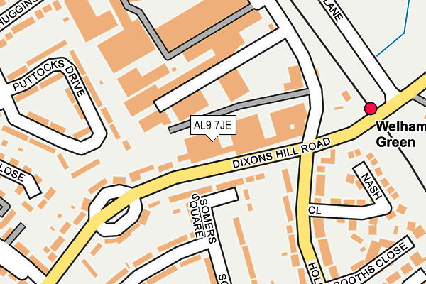
AL9 7JE is located in the Welham Green and Hatfield South electoral ward, within the local authority district of Welwyn Hatfield and the English Parliamentary constituency of Welwyn Hatfield. The Sub Integrated Care Board (ICB) Location is NHS Hertfordshire and West Essex ICB - 06K and the police force is Hertfordshire. This postcode has been in use since February 1990.


GetTheData
Source: OS OpenMap – Local (Ordnance Survey)
Source: OS VectorMap District (Ordnance Survey)
Licence: Open Government Licence (requires attribution)
| Easting | 523441 |
| Northing | 205655 |
| Latitude | 51.736020 |
| Longitude | -0.213775 |
GetTheData
Source: Open Postcode Geo
Licence: Open Government Licence
| Country | England |
| Postcode District | AL9 |
➜ See where AL9 is on a map ➜ Where is Welham Green? | |
GetTheData
Source: Land Registry Price Paid Data
Licence: Open Government Licence
Elevation or altitude of AL9 7JE as distance above sea level:
| Metres | Feet | |
|---|---|---|
| Elevation | 90m | 295ft |
Elevation is measured from the approximate centre of the postcode, to the nearest point on an OS contour line from OS Terrain 50, which has contour spacing of ten vertical metres.
➜ How high above sea level am I? Find the elevation of your current position using your device's GPS.
GetTheData
Source: Open Postcode Elevation
Licence: Open Government Licence
| Ward | Welham Green And Hatfield South |
| Constituency | Welwyn Hatfield |
GetTheData
Source: ONS Postcode Database
Licence: Open Government Licence
| Welham Green Railway Station (Station) | Welham Green | 56m |
| Welham Green Railway Station (Dixons Hill Road) | Welham Green | 90m |
| Dixons Hill Road | Welham Green | 274m |
| Dixons Hill Road (Dellsome Lane) | Welham Green | 300m |
| Dellsome Lane | Welham Green | 326m |
| Welham Green Station | 0.2km |
| Brookmans Park Station | 1.8km |
| Hatfield (Herts) Station | 3.1km |
GetTheData
Source: NaPTAN
Licence: Open Government Licence
GetTheData
Source: ONS Postcode Database
Licence: Open Government Licence


➜ Get more ratings from the Food Standards Agency
GetTheData
Source: Food Standards Agency
Licence: FSA terms & conditions
| Last Collection | |||
|---|---|---|---|
| Location | Mon-Fri | Sat | Distance |
| Marshmoor Crescent | 17:00 | 08:00 | 321m |
| North Mymms P O | 18:00 | 11:45 | 344m |
| University Of Hertfordshire | 16:45 | 11:45 | 432m |
GetTheData
Source: Dracos
Licence: Creative Commons Attribution-ShareAlike
The below table lists the International Territorial Level (ITL) codes (formerly Nomenclature of Territorial Units for Statistics (NUTS) codes) and Local Administrative Units (LAU) codes for AL9 7JE:
| ITL 1 Code | Name |
|---|---|
| TLH | East |
| ITL 2 Code | Name |
| TLH2 | Bedfordshire and Hertfordshire |
| ITL 3 Code | Name |
| TLH23 | Hertfordshire CC |
| LAU 1 Code | Name |
| E07000241 | Welwyn Hatfield |
GetTheData
Source: ONS Postcode Directory
Licence: Open Government Licence
The below table lists the Census Output Area (OA), Lower Layer Super Output Area (LSOA), and Middle Layer Super Output Area (MSOA) for AL9 7JE:
| Code | Name | |
|---|---|---|
| OA | E00121682 | |
| LSOA | E01023963 | Welwyn Hatfield 014B |
| MSOA | E02004993 | Welwyn Hatfield 014 |
GetTheData
Source: ONS Postcode Directory
Licence: Open Government Licence
| AL9 7PS | Somers Square | 64m |
| AL9 7NU | Holloways Lane | 165m |
| AL9 7DQ | Churchill Crescent | 168m |
| AL9 7NG | Barfolds | 171m |
| AL9 7LW | Puttocks Drive | 182m |
| AL9 7NS | Holloways Lane | 182m |
| AL9 7PR | Somers Road | 183m |
| AL9 7PX | Somers Road | 215m |
| AL9 7NT | Travellers Close | 234m |
| AL9 7PT | Somers Road | 238m |
GetTheData
Source: Open Postcode Geo; Land Registry Price Paid Data
Licence: Open Government Licence