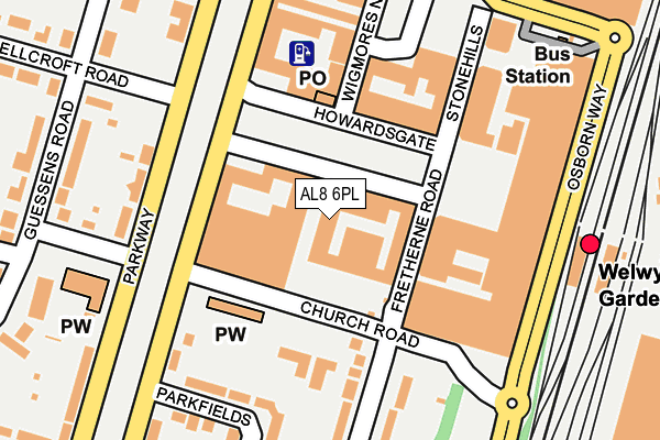
AL8 6PL lies on Wigmores South in Welwyn Garden City. AL8 6PL is located in the Handside electoral ward, within the local authority district of Welwyn Hatfield and the English Parliamentary constituency of Welwyn Hatfield. The Sub Integrated Care Board (ICB) Location is NHS Hertfordshire and West Essex ICB - 06K and the police force is Hertfordshire. This postcode has been in use since January 1980.


GetTheData
Source: OS OpenMap – Local (Ordnance Survey)
Source: OS VectorMap District (Ordnance Survey)
Licence: Open Government Licence (requires attribution)
| Easting | 523693 |
| Northing | 212913 |
| Latitude | 51.801196 |
| Longitude | -0.207522 |
GetTheData
Source: Open Postcode Geo
Licence: Open Government Licence
| Street | Wigmores South |
| Town/City | Welwyn Garden City |
| Country | England |
| Postcode District | AL8 |
➜ See where AL8 is on a map ➜ Where is Welwyn Garden City? | |
GetTheData
Source: Land Registry Price Paid Data
Licence: Open Government Licence
Elevation or altitude of AL8 6PL as distance above sea level:
| Metres | Feet | |
|---|---|---|
| Elevation | 90m | 295ft |
Elevation is measured from the approximate centre of the postcode, to the nearest point on an OS contour line from OS Terrain 50, which has contour spacing of ten vertical metres.
➜ How high above sea level am I? Find the elevation of your current position using your device's GPS.
GetTheData
Source: Open Postcode Elevation
Licence: Open Government Licence
| Ward | Handside |
| Constituency | Welwyn Hatfield |
GetTheData
Source: ONS Postcode Database
Licence: Open Government Licence
| Sainsburys (Church Road) | Welwyn Garden City | 79m |
| Russellcroft Road | Welwyn Garden City | 175m |
| Russellcroft Road (Guessens Road) | Welwyn Garden City | 234m |
| Church Road (Guessens Road) | Welwyn Garden City | 287m |
| John Lewis (Bridge Road) | Welwyn Garden City | 290m |
| Welwyn Garden City Station | 0.2km |
| Welwyn North Station | 2.7km |
| Hatfield (Herts) Station | 4.2km |
GetTheData
Source: NaPTAN
Licence: Open Government Licence
| Percentage of properties with Next Generation Access | 100.0% |
| Percentage of properties with Superfast Broadband | 100.0% |
| Percentage of properties with Ultrafast Broadband | 100.0% |
| Percentage of properties with Full Fibre Broadband | 0.0% |
Superfast Broadband is between 30Mbps and 300Mbps
Ultrafast Broadband is > 300Mbps
| Median download speed | 21.9Mbps |
| Average download speed | 23.2Mbps |
| Maximum download speed | 40.00Mbps |
| Median upload speed | 1.2Mbps |
| Average upload speed | 2.7Mbps |
| Maximum upload speed | 10.00Mbps |
| Percentage of properties unable to receive 2Mbps | 0.0% |
| Percentage of properties unable to receive 5Mbps | 0.0% |
| Percentage of properties unable to receive 10Mbps | 0.0% |
| Percentage of properties unable to receive 30Mbps | 0.0% |
GetTheData
Source: Ofcom
Licence: Ofcom Terms of Use (requires attribution)
GetTheData
Source: ONS Postcode Database
Licence: Open Government Licence


➜ Get more ratings from the Food Standards Agency
GetTheData
Source: Food Standards Agency
Licence: FSA terms & conditions
| Last Collection | |||
|---|---|---|---|
| Location | Mon-Fri | Sat | Distance |
| Howardsgate Branch Office | 18:25 | 12:00 | 91m |
| Church Road | 17:30 | 11:30 | 239m |
| Howard Centre | 18:25 | 12:00 | 252m |
GetTheData
Source: Dracos
Licence: Creative Commons Attribution-ShareAlike
The below table lists the International Territorial Level (ITL) codes (formerly Nomenclature of Territorial Units for Statistics (NUTS) codes) and Local Administrative Units (LAU) codes for AL8 6PL:
| ITL 1 Code | Name |
|---|---|
| TLH | East |
| ITL 2 Code | Name |
| TLH2 | Bedfordshire and Hertfordshire |
| ITL 3 Code | Name |
| TLH23 | Hertfordshire CC |
| LAU 1 Code | Name |
| E07000241 | Welwyn Hatfield |
GetTheData
Source: ONS Postcode Directory
Licence: Open Government Licence
The below table lists the Census Output Area (OA), Lower Layer Super Output Area (LSOA), and Middle Layer Super Output Area (MSOA) for AL8 6PL:
| Code | Name | |
|---|---|---|
| OA | E00121437 | |
| LSOA | E01023918 | Welwyn Hatfield 006C |
| MSOA | E02004985 | Welwyn Hatfield 006 |
GetTheData
Source: ONS Postcode Directory
Licence: Open Government Licence
| AL8 6BH | Howardsgate | 42m |
| AL8 6DJ | Howardsgate | 42m |
| AL8 6DH | Parkway | 61m |
| AL8 6PS | Church Road | 65m |
| AL8 6PA | Howardsgate | 84m |
| AL8 6PB | Howardsgate | 84m |
| AL8 6AL | Howardsgate | 111m |
| AL8 6PG | Wigmores North | 136m |
| AL8 6PZ | Fretherne Road | 149m |
| AL8 6PD | Stonehills | 149m |
GetTheData
Source: Open Postcode Geo; Land Registry Price Paid Data
Licence: Open Government Licence