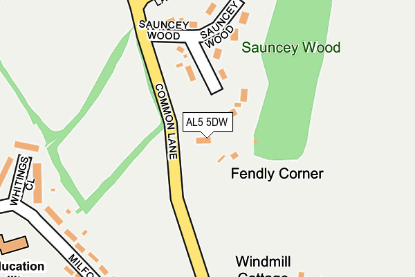
AL5 5DW is located in the Sandridge & Wheathampstead electoral ward, within the local authority district of St Albans and the English Parliamentary constituency of Hitchin and Harpenden. The Sub Integrated Care Board (ICB) Location is NHS Hertfordshire and West Essex ICB - 06N and the police force is Hertfordshire. This postcode has been in use since January 1980.


GetTheData
Source: OS OpenMap – Local (Ordnance Survey)
Source: OS VectorMap District (Ordnance Survey)
Licence: Open Government Licence (requires attribution)
| Easting | 515025 |
| Northing | 215784 |
| Latitude | 51.828840 |
| Longitude | -0.332241 |
GetTheData
Source: Open Postcode Geo
Licence: Open Government Licence
| Country | England |
| Postcode District | AL5 |
➜ See where AL5 is on a map | |
GetTheData
Source: Land Registry Price Paid Data
Licence: Open Government Licence
Elevation or altitude of AL5 5DW as distance above sea level:
| Metres | Feet | |
|---|---|---|
| Elevation | 110m | 361ft |
Elevation is measured from the approximate centre of the postcode, to the nearest point on an OS contour line from OS Terrain 50, which has contour spacing of ten vertical metres.
➜ How high above sea level am I? Find the elevation of your current position using your device's GPS.
GetTheData
Source: Open Postcode Elevation
Licence: Open Government Licence
| Ward | Sandridge & Wheathampstead |
| Constituency | Hitchin And Harpenden |
GetTheData
Source: ONS Postcode Database
Licence: Open Government Licence
| Whitings Close (Milford Hill) | Batford | 285m |
| Holcroft Road (Milford Hill) | Batford | 293m |
| Whitings Close (Pickford Hill) | Batford | 331m |
| Holcroft Road (Milford Hill) | Batford | 358m |
| Tallents Crescent (Milford Hill) | Batford | 450m |
| Harpenden Station | 2.1km |
| Luton Airport Parkway Station | 6.5km |
GetTheData
Source: NaPTAN
Licence: Open Government Licence
| Percentage of properties with Next Generation Access | 100.0% |
| Percentage of properties with Superfast Broadband | 0.0% |
| Percentage of properties with Ultrafast Broadband | 0.0% |
| Percentage of properties with Full Fibre Broadband | 0.0% |
Superfast Broadband is between 30Mbps and 300Mbps
Ultrafast Broadband is > 300Mbps
| Percentage of properties unable to receive 2Mbps | 0.0% |
| Percentage of properties unable to receive 5Mbps | 0.0% |
| Percentage of properties unable to receive 10Mbps | 0.0% |
| Percentage of properties unable to receive 30Mbps | 100.0% |
GetTheData
Source: Ofcom
Licence: Ofcom Terms of Use (requires attribution)
GetTheData
Source: ONS Postcode Database
Licence: Open Government Licence


➜ Get more ratings from the Food Standards Agency
GetTheData
Source: Food Standards Agency
Licence: FSA terms & conditions
| Last Collection | |||
|---|---|---|---|
| Location | Mon-Fri | Sat | Distance |
| Holcroft Road | 17:45 | 12:00 | 357m |
| Noke Shot | 17:45 | 12:00 | 577m |
| Southview Road | 17:45 | 12:00 | 707m |
GetTheData
Source: Dracos
Licence: Creative Commons Attribution-ShareAlike
The below table lists the International Territorial Level (ITL) codes (formerly Nomenclature of Territorial Units for Statistics (NUTS) codes) and Local Administrative Units (LAU) codes for AL5 5DW:
| ITL 1 Code | Name |
|---|---|
| TLH | East |
| ITL 2 Code | Name |
| TLH2 | Bedfordshire and Hertfordshire |
| ITL 3 Code | Name |
| TLH23 | Hertfordshire CC |
| LAU 1 Code | Name |
| E07000240 | St Albans |
GetTheData
Source: ONS Postcode Directory
Licence: Open Government Licence
The below table lists the Census Output Area (OA), Lower Layer Super Output Area (LSOA), and Middle Layer Super Output Area (MSOA) for AL5 5DW:
| Code | Name | |
|---|---|---|
| OA | E00120594 | |
| LSOA | E01023748 | St Albans 004C |
| MSOA | E02004927 | St Albans 004 |
GetTheData
Source: ONS Postcode Directory
Licence: Open Government Licence
| AL5 5DP | Sauncey Wood | 159m |
| AL5 5BJ | Milford Hill | 243m |
| AL5 5HJ | Pickford Hill | 246m |
| AL5 5HH | Whitings Close | 251m |
| AL5 5BH | Milford Hill | 282m |
| AL5 5BL | Milford Hill | 390m |
| AL5 5BQ | Holcroft Road | 398m |
| AL5 5HQ | Pickford Hill | 400m |
| AL5 5BG | Holcroft Road | 431m |
| AL5 5BW | Finley Road | 446m |
GetTheData
Source: Open Postcode Geo; Land Registry Price Paid Data
Licence: Open Government Licence