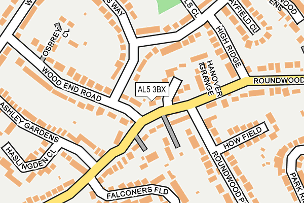
AL5 3BX is in Chadwell Heath Lane, Harpenden. AL5 3BX is located in the Harpenden North & Rural electoral ward, within the local authority district of St Albans and the English Parliamentary constituency of Hitchin and Harpenden. The Sub Integrated Care Board (ICB) Location is NHS Hertfordshire and West Essex ICB - 06N and the police force is Hertfordshire. This postcode has been in use since January 1980.


GetTheData
Source: OS OpenMap – Local (Ordnance Survey)
Source: OS VectorMap District (Ordnance Survey)
Licence: Open Government Licence (requires attribution)
| Easting | 512009 |
| Northing | 215307 |
| Latitude | 51.825172 |
| Longitude | -0.376118 |
GetTheData
Source: Open Postcode Geo
Licence: Open Government Licence
| Locality | Chadwell Heath Lane |
| Town/City | Harpenden |
| Country | England |
| Postcode District | AL5 |
➜ See where AL5 is on a map ➜ Where is Harpenden? | |
GetTheData
Source: Land Registry Price Paid Data
Licence: Open Government Licence
Elevation or altitude of AL5 3BX as distance above sea level:
| Metres | Feet | |
|---|---|---|
| Elevation | 130m | 427ft |
Elevation is measured from the approximate centre of the postcode, to the nearest point on an OS contour line from OS Terrain 50, which has contour spacing of ten vertical metres.
➜ How high above sea level am I? Find the elevation of your current position using your device's GPS.
GetTheData
Source: Open Postcode Elevation
Licence: Open Government Licence
| Ward | Harpenden North & Rural |
| Constituency | Hitchin And Harpenden |
GetTheData
Source: ONS Postcode Database
Licence: Open Government Licence
38, ROUNDWOOD LANE, HARPENDEN, AL5 3BX 2022 5 JUL £1,425,000 |
32, CHADWELL HEATH LANE, HARPENDEN, AL5 3BX 2004 25 AUG £805,000 |
GetTheData
Source: HM Land Registry Price Paid Data
Licence: Contains HM Land Registry data © Crown copyright and database right 2025. This data is licensed under the Open Government Licence v3.0.
| Ridgewood Drive (Luton Road) | Harpenden | 425m |
| Ridgewood Drive (Luton Road) | Harpenden | 440m |
| Roundwood Lane (Luton Road) | Harpenden | 535m |
| Farm Avenue (Luton Road) | Harpenden | 546m |
| Roundwood Lane (Luton Road) | Harpenden | 551m |
| Harpenden Station | 2.1km |
GetTheData
Source: NaPTAN
Licence: Open Government Licence
| Percentage of properties with Next Generation Access | 100.0% |
| Percentage of properties with Superfast Broadband | 100.0% |
| Percentage of properties with Ultrafast Broadband | 0.0% |
| Percentage of properties with Full Fibre Broadband | 0.0% |
Superfast Broadband is between 30Mbps and 300Mbps
Ultrafast Broadband is > 300Mbps
| Percentage of properties unable to receive 2Mbps | 0.0% |
| Percentage of properties unable to receive 5Mbps | 0.0% |
| Percentage of properties unable to receive 10Mbps | 0.0% |
| Percentage of properties unable to receive 30Mbps | 0.0% |
GetTheData
Source: Ofcom
Licence: Ofcom Terms of Use (requires attribution)
GetTheData
Source: ONS Postcode Database
Licence: Open Government Licence


➜ Get more ratings from the Food Standards Agency
GetTheData
Source: Food Standards Agency
Licence: FSA terms & conditions
| Last Collection | |||
|---|---|---|---|
| Location | Mon-Fri | Sat | Distance |
| Roundwood Lane | 17:00 | 11:45 | 74m |
| Ridgewood Drive | 17:00 | 11:45 | 389m |
| Park Rise | 17:00 | 11:30 | 567m |
GetTheData
Source: Dracos
Licence: Creative Commons Attribution-ShareAlike
The below table lists the International Territorial Level (ITL) codes (formerly Nomenclature of Territorial Units for Statistics (NUTS) codes) and Local Administrative Units (LAU) codes for AL5 3BX:
| ITL 1 Code | Name |
|---|---|
| TLH | East |
| ITL 2 Code | Name |
| TLH2 | Bedfordshire and Hertfordshire |
| ITL 3 Code | Name |
| TLH23 | Hertfordshire CC |
| LAU 1 Code | Name |
| E07000240 | St Albans |
GetTheData
Source: ONS Postcode Directory
Licence: Open Government Licence
The below table lists the Census Output Area (OA), Lower Layer Super Output Area (LSOA), and Middle Layer Super Output Area (MSOA) for AL5 3BX:
| Code | Name | |
|---|---|---|
| OA | E00120322 | |
| LSOA | E01023691 | St Albans 001B |
| MSOA | E02004924 | St Albans 001 |
GetTheData
Source: ONS Postcode Directory
Licence: Open Government Licence
| AL5 3EB | Wood End Road | 34m |
| AL5 3BY | Woodlands | 50m |
| AL5 3BS | Roundwood Lane | 59m |
| AL5 3HH | Tuffnells Way | 67m |
| AL5 3BT | Applewood Close | 101m |
| AL5 3BD | Hanover Grange | 109m |
| AL5 3LJ | Ridgewood Drive | 110m |
| AL5 3LH | Ridgewood Drive | 149m |
| AL5 3EX | Roundwood Lane | 159m |
| AL5 3LL | High Ridge | 162m |
GetTheData
Source: Open Postcode Geo; Land Registry Price Paid Data
Licence: Open Government Licence