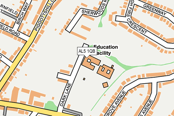
AL5 1QB is located in the Harpenden South electoral ward, within the local authority district of St Albans and the English Parliamentary constituency of Hitchin and Harpenden. The Sub Integrated Care Board (ICB) Location is NHS Hertfordshire and West Essex ICB - 06N and the police force is Hertfordshire. This postcode has been in use since January 1980.


GetTheData
Source: OS OpenMap – Local (Ordnance Survey)
Source: OS VectorMap District (Ordnance Survey)
Licence: Open Government Licence (requires attribution)
| Easting | 514703 |
| Northing | 213495 |
| Latitude | 51.808334 |
| Longitude | -0.337669 |
GetTheData
Source: Open Postcode Geo
Licence: Open Government Licence
| Country | England |
| Postcode District | AL5 |
➜ See where AL5 is on a map ➜ Where is Harpenden? | |
GetTheData
Source: Land Registry Price Paid Data
Licence: Open Government Licence
Elevation or altitude of AL5 1QB as distance above sea level:
| Metres | Feet | |
|---|---|---|
| Elevation | 110m | 361ft |
Elevation is measured from the approximate centre of the postcode, to the nearest point on an OS contour line from OS Terrain 50, which has contour spacing of ten vertical metres.
➜ How high above sea level am I? Find the elevation of your current position using your device's GPS.
GetTheData
Source: Open Postcode Elevation
Licence: Open Government Licence
| Ward | Harpenden South |
| Constituency | Hitchin And Harpenden |
GetTheData
Source: ONS Postcode Database
Licence: Open Government Licence
| Barnfield Road (Piggottshill Lane) | Harpenden | 197m |
| Grove Road | Harpenden | 217m |
| Barnfield Road (Piggottshill Lane) | Harpenden | 219m |
| Pipers Avenue (Grove Avenue) | Harpenden | 229m |
| Highfield Avenue (Topstreet Way) | Harpenden | 276m |
| Harpenden Station | 1.2km |
GetTheData
Source: NaPTAN
Licence: Open Government Licence
GetTheData
Source: ONS Postcode Database
Licence: Open Government Licence


➜ Get more ratings from the Food Standards Agency
GetTheData
Source: Food Standards Agency
Licence: FSA terms & conditions
| Last Collection | |||
|---|---|---|---|
| Location | Mon-Fri | Sat | Distance |
| Piggottshill Lane | 17:45 | 12:15 | 213m |
| Greenway | 17:45 | 12:15 | 358m |
| Southdown Road P.o. | 18:30 | 12:00 | 369m |
GetTheData
Source: Dracos
Licence: Creative Commons Attribution-ShareAlike
The below table lists the International Territorial Level (ITL) codes (formerly Nomenclature of Territorial Units for Statistics (NUTS) codes) and Local Administrative Units (LAU) codes for AL5 1QB:
| ITL 1 Code | Name |
|---|---|
| TLH | East |
| ITL 2 Code | Name |
| TLH2 | Bedfordshire and Hertfordshire |
| ITL 3 Code | Name |
| TLH23 | Hertfordshire CC |
| LAU 1 Code | Name |
| E07000240 | St Albans |
GetTheData
Source: ONS Postcode Directory
Licence: Open Government Licence
The below table lists the Census Output Area (OA), Lower Layer Super Output Area (LSOA), and Middle Layer Super Output Area (MSOA) for AL5 1QB:
| Code | Name | |
|---|---|---|
| OA | E00120327 | |
| LSOA | E01023697 | St Albans 005C |
| MSOA | E02004928 | St Albans 005 |
GetTheData
Source: ONS Postcode Directory
Licence: Open Government Licence
| AL5 1LX | Sherwoods Rise | 105m |
| AL5 1QA | Dark Lane | 118m |
| AL5 1EU | Grove Avenue | 154m |
| AL5 1LU | Sherwoods Rise | 161m |
| AL5 1NA | High Firs Crescent | 187m |
| AL5 1LP | Piggottshill Lane | 192m |
| AL5 1EX | Grove Avenue | 200m |
| AL5 1LW | Piggottshill Lane | 203m |
| AL5 1EN | Grove Road | 224m |
| AL5 1LR | Piggottshill Lane | 233m |
GetTheData
Source: Open Postcode Geo; Land Registry Price Paid Data
Licence: Open Government Licence