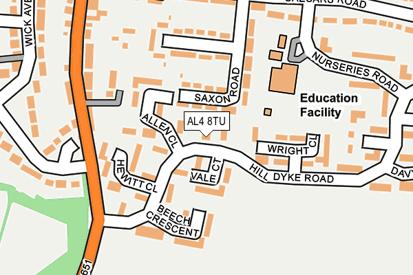
AL4 8TU is located in the Sandridge & Wheathampstead electoral ward, within the local authority district of St Albans and the English Parliamentary constituency of Hitchin and Harpenden. The Sub Integrated Care Board (ICB) Location is NHS Hertfordshire and West Essex ICB - 06N and the police force is Hertfordshire. This postcode has been in use since June 2000.


GetTheData
Source: OS OpenMap – Local (Ordnance Survey)
Source: OS VectorMap District (Ordnance Survey)
Licence: Open Government Licence (requires attribution)
| Easting | 517880 |
| Northing | 213352 |
| Latitude | 51.806389 |
| Longitude | -0.291658 |
GetTheData
Source: Open Postcode Geo
Licence: Open Government Licence
| Country | England |
| Postcode District | AL4 |
➜ See where AL4 is on a map ➜ Where is Wheathampstead? | |
GetTheData
Source: Land Registry Price Paid Data
Licence: Open Government Licence
Elevation or altitude of AL4 8TU as distance above sea level:
| Metres | Feet | |
|---|---|---|
| Elevation | 110m | 361ft |
Elevation is measured from the approximate centre of the postcode, to the nearest point on an OS contour line from OS Terrain 50, which has contour spacing of ten vertical metres.
➜ How high above sea level am I? Find the elevation of your current position using your device's GPS.
GetTheData
Source: Open Postcode Elevation
Licence: Open Government Licence
| Ward | Sandridge & Wheathampstead |
| Constituency | Hitchin And Harpenden |
GetTheData
Source: ONS Postcode Database
Licence: Open Government Licence
| Vale Court (Hill Dyke Road) | Wheathampstead | 25m |
| Vale Court (Hill Dyke Road) | Wheathampstead | 99m |
| Hill Dyke Road (The Hill) | Wheathampstead | 174m |
| Hill Dyke Road (The Hill) | Wheathampstead | 189m |
| Lamer Fields (Nurseries Road) | Wheathampstead | 206m |
| Harpenden Station | 4.2km |
GetTheData
Source: NaPTAN
Licence: Open Government Licence
GetTheData
Source: ONS Postcode Database
Licence: Open Government Licence


➜ Get more ratings from the Food Standards Agency
GetTheData
Source: Food Standards Agency
Licence: FSA terms & conditions
| Last Collection | |||
|---|---|---|---|
| Location | Mon-Fri | Sat | Distance |
| Butterfield Road | 16:15 | 10:00 | 363m |
| Necton Road Wheathampstead | 16:00 | 10:15 | 475m |
| Old Rectory Gardens | 16:15 | 10:15 | 643m |
GetTheData
Source: Dracos
Licence: Creative Commons Attribution-ShareAlike
The below table lists the International Territorial Level (ITL) codes (formerly Nomenclature of Territorial Units for Statistics (NUTS) codes) and Local Administrative Units (LAU) codes for AL4 8TU:
| ITL 1 Code | Name |
|---|---|
| TLH | East |
| ITL 2 Code | Name |
| TLH2 | Bedfordshire and Hertfordshire |
| ITL 3 Code | Name |
| TLH23 | Hertfordshire CC |
| LAU 1 Code | Name |
| E07000240 | St Albans |
GetTheData
Source: ONS Postcode Directory
Licence: Open Government Licence
The below table lists the Census Output Area (OA), Lower Layer Super Output Area (LSOA), and Middle Layer Super Output Area (MSOA) for AL4 8TU:
| Code | Name | |
|---|---|---|
| OA | E00120590 | |
| LSOA | E01023746 | St Albans 004A |
| MSOA | E02004927 | St Albans 004 |
GetTheData
Source: ONS Postcode Directory
Licence: Open Government Licence
| AL4 8TG | Hilldyke Road | 24m |
| AL4 8TB | Hilldyke Road | 65m |
| AL4 8TE | Vale Court | 76m |
| AL4 8TH | Allen Close | 77m |
| AL4 8NY | Saxon Road | 96m |
| AL4 8TQ | Hewitt Close | 118m |
| AL4 8NZ | Saxon Road | 121m |
| AL4 8TD | Beech Crescent | 129m |
| AL4 8TJ | Wright Close | 129m |
| AL4 8TF | Hilldyke Road | 157m |
GetTheData
Source: Open Postcode Geo; Land Registry Price Paid Data
Licence: Open Government Licence