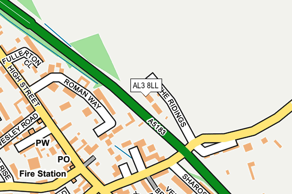
AL3 8LL lies on The Ridings in Markyate, St. Albans. AL3 8LL is located in the Watling electoral ward, within the local authority district of Dacorum and the English Parliamentary constituency of Hemel Hempstead. The Sub Integrated Care Board (ICB) Location is NHS Hertfordshire and West Essex ICB - 06N and the police force is Hertfordshire. This postcode has been in use since January 1980.


GetTheData
Source: OS OpenMap – Local (Ordnance Survey)
Source: OS VectorMap District (Ordnance Survey)
Licence: Open Government Licence (requires attribution)
| Easting | 506301 |
| Northing | 216534 |
| Latitude | 51.837307 |
| Longitude | -0.458556 |
GetTheData
Source: Open Postcode Geo
Licence: Open Government Licence
| Street | The Ridings |
| Locality | Markyate |
| Town/City | St. Albans |
| Country | England |
| Postcode District | AL3 |
➜ See where AL3 is on a map ➜ Where is Markyate? | |
GetTheData
Source: Land Registry Price Paid Data
Licence: Open Government Licence
Elevation or altitude of AL3 8LL as distance above sea level:
| Metres | Feet | |
|---|---|---|
| Elevation | 130m | 427ft |
Elevation is measured from the approximate centre of the postcode, to the nearest point on an OS contour line from OS Terrain 50, which has contour spacing of ten vertical metres.
➜ How high above sea level am I? Find the elevation of your current position using your device's GPS.
GetTheData
Source: Open Postcode Elevation
Licence: Open Government Licence
| Ward | Watling |
| Constituency | Hemel Hempstead |
GetTheData
Source: ONS Postcode Database
Licence: Open Government Licence
| Hicks Road (Markyate Bypass) | Markyate | 72m |
| Hicks Road (Markyate Bypass) | Markyate | 87m |
| Hicks Road Terminus (Hicks Road) | Markyate | 180m |
| Fire Station (High Street) | Markyate | 197m |
| Fire Station (High Street) | Markyate | 202m |
| Luton Airport Parkway Station | 5.8km |
GetTheData
Source: NaPTAN
Licence: Open Government Licence
| Percentage of properties with Next Generation Access | 100.0% |
| Percentage of properties with Superfast Broadband | 100.0% |
| Percentage of properties with Ultrafast Broadband | 100.0% |
| Percentage of properties with Full Fibre Broadband | 100.0% |
Superfast Broadband is between 30Mbps and 300Mbps
Ultrafast Broadband is > 300Mbps
| Percentage of properties unable to receive 2Mbps | 0.0% |
| Percentage of properties unable to receive 5Mbps | 0.0% |
| Percentage of properties unable to receive 10Mbps | 0.0% |
| Percentage of properties unable to receive 30Mbps | 0.0% |
GetTheData
Source: Ofcom
Licence: Ofcom Terms of Use (requires attribution)
GetTheData
Source: ONS Postcode Database
Licence: Open Government Licence


➜ Get more ratings from the Food Standards Agency
GetTheData
Source: Food Standards Agency
Licence: FSA terms & conditions
| Last Collection | |||
|---|---|---|---|
| Location | Mon-Fri | Sat | Distance |
| Alley Green | 17:00 | 07:30 | 1,896m |
| Packhorse Place | 17:15 | 09:00 | 1,963m |
| Lower Woodside | 17:00 | 08:30 | 2,045m |
GetTheData
Source: Dracos
Licence: Creative Commons Attribution-ShareAlike
The below table lists the International Territorial Level (ITL) codes (formerly Nomenclature of Territorial Units for Statistics (NUTS) codes) and Local Administrative Units (LAU) codes for AL3 8LL:
| ITL 1 Code | Name |
|---|---|
| TLH | East |
| ITL 2 Code | Name |
| TLH2 | Bedfordshire and Hertfordshire |
| ITL 3 Code | Name |
| TLH23 | Hertfordshire CC |
| LAU 1 Code | Name |
| E07000096 | Dacorum |
GetTheData
Source: ONS Postcode Directory
Licence: Open Government Licence
The below table lists the Census Output Area (OA), Lower Layer Super Output Area (LSOA), and Middle Layer Super Output Area (MSOA) for AL3 8LL:
| Code | Name | |
|---|---|---|
| OA | E00119031 | |
| LSOA | E01023432 | Dacorum 001C |
| MSOA | E02004856 | Dacorum 001 |
GetTheData
Source: ONS Postcode Directory
Licence: Open Government Licence
| AL3 8LJ | Hicks Road | 97m |
| AL3 8FG | Fleming Drive | 108m |
| AL3 8LY | Roman Way | 125m |
| AL3 8JG | High Street | 186m |
| AL3 8LN | Harps Hill | 198m |
| AL3 8HZ | High Street | 202m |
| AL3 8JH | Sharose Court | 211m |
| AL3 8PJ | High Street | 213m |
| AL3 8LF | High Street | 214m |
| AL3 8FH | Ver Brook Avenue | 220m |
GetTheData
Source: Open Postcode Geo; Land Registry Price Paid Data
Licence: Open Government Licence