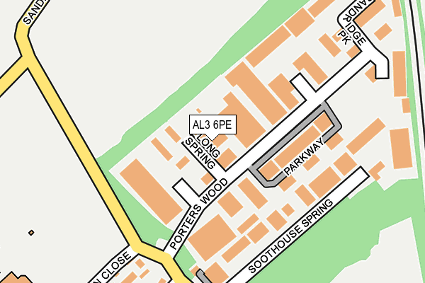
AL3 6PE is located in the Bernards Heath electoral ward, within the local authority district of St Albans and the English Parliamentary constituency of St Albans. The Sub Integrated Care Board (ICB) Location is NHS Hertfordshire and West Essex ICB - 06N and the police force is Hertfordshire. This postcode has been in use since January 1980.


GetTheData
Source: OS OpenMap – Local (Ordnance Survey)
Source: OS VectorMap District (Ordnance Survey)
Licence: Open Government Licence (requires attribution)
| Easting | 515542 |
| Northing | 209429 |
| Latitude | 51.771620 |
| Longitude | -0.326858 |
GetTheData
Source: Open Postcode Geo
Licence: Open Government Licence
| Country | England |
| Postcode District | AL3 |
➜ See where AL3 is on a map ➜ Where is St Albans? | |
GetTheData
Source: Land Registry Price Paid Data
Licence: Open Government Licence
Elevation or altitude of AL3 6PE as distance above sea level:
| Metres | Feet | |
|---|---|---|
| Elevation | 110m | 361ft |
Elevation is measured from the approximate centre of the postcode, to the nearest point on an OS contour line from OS Terrain 50, which has contour spacing of ten vertical metres.
➜ How high above sea level am I? Find the elevation of your current position using your device's GPS.
GetTheData
Source: Open Postcode Elevation
Licence: Open Government Licence
| Ward | Bernards Heath |
| Constituency | St Albans |
GetTheData
Source: ONS Postcode Database
Licence: Open Government Licence
| St Albans Girls School (Girls School) | New Greens | 440m |
| Firbank Road | St Albans | 453m |
| Valley Road | St Albans | 479m |
| St Albans Girls School (Harpenden Road) | New Greens | 507m |
| St Albans Girls School (Harpenden Road) | New Greens | 524m |
| St Albans City Station | 2.4km |
| St Albans Abbey Station | 3.2km |
| Harpenden Station | 5.1km |
GetTheData
Source: NaPTAN
Licence: Open Government Licence
GetTheData
Source: ONS Postcode Database
Licence: Open Government Licence


➜ Get more ratings from the Food Standards Agency
GetTheData
Source: Food Standards Agency
Licence: FSA terms & conditions
| Last Collection | |||
|---|---|---|---|
| Location | Mon-Fri | Sat | Distance |
| Porters Wood | 18:30 | 12:00 | 45m |
| Porterswood | 18:30 | 236m | |
| Beech Road P.o | 18:30 | 12:00 | 581m |
GetTheData
Source: Dracos
Licence: Creative Commons Attribution-ShareAlike
The below table lists the International Territorial Level (ITL) codes (formerly Nomenclature of Territorial Units for Statistics (NUTS) codes) and Local Administrative Units (LAU) codes for AL3 6PE:
| ITL 1 Code | Name |
|---|---|
| TLH | East |
| ITL 2 Code | Name |
| TLH2 | Bedfordshire and Hertfordshire |
| ITL 3 Code | Name |
| TLH23 | Hertfordshire CC |
| LAU 1 Code | Name |
| E07000240 | St Albans |
GetTheData
Source: ONS Postcode Directory
Licence: Open Government Licence
The below table lists the Census Output Area (OA), Lower Layer Super Output Area (LSOA), and Middle Layer Super Output Area (MSOA) for AL3 6PE:
| Code | Name | |
|---|---|---|
| OA | E00120420 | |
| LSOA | E01023713 | St Albans 007A |
| MSOA | E02004930 | St Albans 007 |
GetTheData
Source: ONS Postcode Directory
Licence: Open Government Licence
| AL3 6PQ | Porters Wood | 93m |
| AL3 6PD | Spring Valley Business Centre | 115m |
| AL3 6PA | Parkway | 117m |
| AL3 6PF | Soothouse Spring | 150m |
| AL3 6XT | The Caxton Centre | 165m |
| AL3 6LJ | Potters Field | 265m |
| AL3 6LH | Darwin Close | 268m |
| AL3 6NB | Valley Road | 295m |
| AL3 6LY | Melbourne Close | 301m |
| AL3 6LX | Melbourne Close | 315m |
GetTheData
Source: Open Postcode Geo; Land Registry Price Paid Data
Licence: Open Government Licence