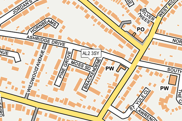
AL2 3SY lies on Brackendene in Bricket Wood, St. Albans. AL2 3SY is located in the St Stephen electoral ward, within the local authority district of St Albans and the English Parliamentary constituency of St Albans. The Sub Integrated Care Board (ICB) Location is NHS Hertfordshire and West Essex ICB - 06N and the police force is Hertfordshire. This postcode has been in use since January 1980.


GetTheData
Source: OS OpenMap – Local (Ordnance Survey)
Source: OS VectorMap District (Ordnance Survey)
Licence: Open Government Licence (requires attribution)
| Easting | 512790 |
| Northing | 202230 |
| Latitude | 51.707480 |
| Longitude | -0.369056 |
GetTheData
Source: Open Postcode Geo
Licence: Open Government Licence
| Street | Brackendene |
| Locality | Bricket Wood |
| Town/City | St. Albans |
| Country | England |
| Postcode District | AL2 |
➜ See where AL2 is on a map ➜ Where is Bricket Wood? | |
GetTheData
Source: Land Registry Price Paid Data
Licence: Open Government Licence
Elevation or altitude of AL2 3SY as distance above sea level:
| Metres | Feet | |
|---|---|---|
| Elevation | 80m | 262ft |
Elevation is measured from the approximate centre of the postcode, to the nearest point on an OS contour line from OS Terrain 50, which has contour spacing of ten vertical metres.
➜ How high above sea level am I? Find the elevation of your current position using your device's GPS.
GetTheData
Source: Open Postcode Elevation
Licence: Open Government Licence
| Ward | St Stephen |
| Constituency | St Albans |
GetTheData
Source: ONS Postcode Database
Licence: Open Government Licence
| United Reformed Church (West Riding) | Bricket Wood | 123m |
| United Reformed Church (West Riding) | Bricket Wood | 132m |
| West Riding (Mount Pleasant Lane) | Bricket Wood | 179m |
| West Riding (Mount Pleasant Lane) | Bricket Wood | 189m |
| North Riding (West Riding) | Bricket Wood | 238m |
| Bricket Wood Station | 0.7km |
| How Wood (Herts) Station | 2km |
| Garston (Herts) Station | 2.5km |
GetTheData
Source: NaPTAN
Licence: Open Government Licence
| Percentage of properties with Next Generation Access | 100.0% |
| Percentage of properties with Superfast Broadband | 100.0% |
| Percentage of properties with Ultrafast Broadband | 100.0% |
| Percentage of properties with Full Fibre Broadband | 0.0% |
Superfast Broadband is between 30Mbps and 300Mbps
Ultrafast Broadband is > 300Mbps
| Median download speed | 100.0Mbps |
| Average download speed | 160.9Mbps |
| Maximum download speed | 350.00Mbps |
| Median upload speed | 9.9Mbps |
| Average upload speed | 9.9Mbps |
| Maximum upload speed | 9.87Mbps |
| Percentage of properties unable to receive 2Mbps | 0.0% |
| Percentage of properties unable to receive 5Mbps | 0.0% |
| Percentage of properties unable to receive 10Mbps | 0.0% |
| Percentage of properties unable to receive 30Mbps | 0.0% |
GetTheData
Source: Ofcom
Licence: Ofcom Terms of Use (requires attribution)
GetTheData
Source: ONS Postcode Database
Licence: Open Government Licence


➜ Get more ratings from the Food Standards Agency
GetTheData
Source: Food Standards Agency
Licence: FSA terms & conditions
| Last Collection | |||
|---|---|---|---|
| Location | Mon-Fri | Sat | Distance |
| Oakwood Road Post Office | 18:30 | 12:00 | 162m |
| Ferndene | 17:30 | 12:00 | 338m |
| How Wood P.o | 18:30 | 12:00 | 1,849m |
GetTheData
Source: Dracos
Licence: Creative Commons Attribution-ShareAlike
The below table lists the International Territorial Level (ITL) codes (formerly Nomenclature of Territorial Units for Statistics (NUTS) codes) and Local Administrative Units (LAU) codes for AL2 3SY:
| ITL 1 Code | Name |
|---|---|
| TLH | East |
| ITL 2 Code | Name |
| TLH2 | Bedfordshire and Hertfordshire |
| ITL 3 Code | Name |
| TLH23 | Hertfordshire CC |
| LAU 1 Code | Name |
| E07000240 | St Albans |
GetTheData
Source: ONS Postcode Directory
Licence: Open Government Licence
The below table lists the Census Output Area (OA), Lower Layer Super Output Area (LSOA), and Middle Layer Super Output Area (MSOA) for AL2 3SY:
| Code | Name | |
|---|---|---|
| OA | E00120520 | |
| LSOA | E01023733 | St Albans 020E |
| MSOA | E02004943 | St Albans 020 |
GetTheData
Source: ONS Postcode Directory
Licence: Open Government Licence
| AL2 3SU | Moss Side | 53m |
| AL2 3SR | Ashridge Drive | 62m |
| AL2 3SX | Brackendene | 67m |
| AL2 3ST | Pine Grove | 90m |
| AL2 3QR | West Riding | 107m |
| AL2 3SS | Pine Grove | 122m |
| AL2 3QA | Oakwood Road | 135m |
| AL2 3QS | West Riding | 137m |
| AL2 3SZ | Ashridge Drive | 142m |
| AL2 3QP | West Riding | 158m |
GetTheData
Source: Open Postcode Geo; Land Registry Price Paid Data
Licence: Open Government Licence