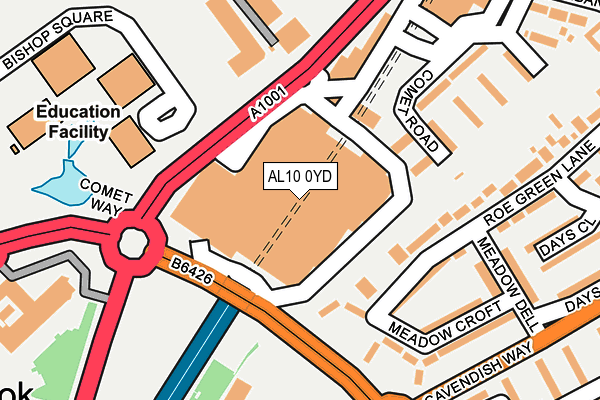
AL10 0YD is located in the Hatfield Central electoral ward, within the local authority district of Welwyn Hatfield and the English Parliamentary constituency of Welwyn Hatfield. The Sub Integrated Care Board (ICB) Location is NHS Hertfordshire and West Essex ICB - 06K and the police force is Hertfordshire. This postcode has been in use since January 1992.


GetTheData
Source: OS OpenMap – Local (Ordnance Survey)
Source: OS VectorMap District (Ordnance Survey)
Licence: Open Government Licence (requires attribution)
| Easting | 521527 |
| Northing | 208393 |
| Latitude | 51.761049 |
| Longitude | -0.240499 |
GetTheData
Source: Open Postcode Geo
Licence: Open Government Licence
| Country | England |
| Postcode District | AL10 |
➜ See where AL10 is on a map ➜ Where is Hatfield? | |
GetTheData
Source: Land Registry Price Paid Data
Licence: Open Government Licence
Elevation or altitude of AL10 0YD as distance above sea level:
| Metres | Feet | |
|---|---|---|
| Elevation | 80m | 262ft |
Elevation is measured from the approximate centre of the postcode, to the nearest point on an OS contour line from OS Terrain 50, which has contour spacing of ten vertical metres.
➜ How high above sea level am I? Find the elevation of your current position using your device's GPS.
GetTheData
Source: Open Postcode Elevation
Licence: Open Government Licence
| Ward | Hatfield Central |
| Constituency | Welwyn Hatfield |
GetTheData
Source: ONS Postcode Database
Licence: Open Government Licence
| The Galleria (Cavendish Way) | Hatfield | 88m |
| The Galleria (Cavendish Way) | Hatfield | 131m |
| The Galleria (Cavendish Way) | Hatfield | 144m |
| The Galleria (Cavendish Way) | Hatfield | 174m |
| Beales Hotel (Comet Way) | Hatfield | 178m |
| Hatfield (Herts) Station | 1.7km |
| Welham Green Station | 3.4km |
| Brookmans Park Station | 5.1km |
GetTheData
Source: NaPTAN
Licence: Open Government Licence
GetTheData
Source: ONS Postcode Database
Licence: Open Government Licence


➜ Get more ratings from the Food Standards Agency
GetTheData
Source: Food Standards Agency
Licence: FSA terms & conditions
| Last Collection | |||
|---|---|---|---|
| Location | Mon-Fri | Sat | Distance |
| The Galleria | 18:30 | 12:00 | 93m |
| Parkhouse Court | 284m | ||
| Grovemead | 17:30 | 12:00 | 440m |
GetTheData
Source: Dracos
Licence: Creative Commons Attribution-ShareAlike
The below table lists the International Territorial Level (ITL) codes (formerly Nomenclature of Territorial Units for Statistics (NUTS) codes) and Local Administrative Units (LAU) codes for AL10 0YD:
| ITL 1 Code | Name |
|---|---|
| TLH | East |
| ITL 2 Code | Name |
| TLH2 | Bedfordshire and Hertfordshire |
| ITL 3 Code | Name |
| TLH23 | Hertfordshire CC |
| LAU 1 Code | Name |
| E07000241 | Welwyn Hatfield |
GetTheData
Source: ONS Postcode Directory
Licence: Open Government Licence
The below table lists the Census Output Area (OA), Lower Layer Super Output Area (LSOA), and Middle Layer Super Output Area (MSOA) for AL10 0YD:
| Code | Name | |
|---|---|---|
| OA | E00121459 | |
| LSOA | E01023921 | Welwyn Hatfield 012B |
| MSOA | E02004991 | Welwyn Hatfield 012 |
GetTheData
Source: ONS Postcode Directory
Licence: Open Government Licence
| AL10 0SJ | Roe Green Lane | 146m |
| AL10 0SH | Roe Green Lane | 165m |
| AL10 0SX | Comet Road | 175m |
| AL10 0SY | Comet Road | 190m |
| AL10 0SG | Meadow Croft | 209m |
| AL10 0SL | Roe Green Lane | 222m |
| AL10 0SF | Meadow Dell | 228m |
| AL10 0SD | Days Close | 262m |
| AL10 9RD | Parkhouse Court | 288m |
| AL10 9RE | Parkhouse Court | 288m |
GetTheData
Source: Open Postcode Geo; Land Registry Price Paid Data
Licence: Open Government Licence