Stoneleigh Village Hall
Stoneleigh Village Hall is located in Stoneleigh, Coventry (CV8), and offers Grass Pitches, Outdoor Tennis Courts, and Artificial Grass Pitch.
| Address | Hall Close, Stoneleigh, Coventry, CV8 3DG |
| Car Park | Yes |
| Car Park Capacity | 40 |
| Management Type | Community Organisation |
| Management Group | Others |
| Owner Type | Community Organisation |
| Owner Group | Community Organisation |
| Education Phase | Not applicable |
Facilities
| Accessibility | Pay and Play |
| Management Type | Community Organisation |
| Changing Rooms | Yes |
| Date Record Created | 18th Sep 2017 |
| Date Record Checked | 31st Oct 2022 |
| Opening Times | Dawn To Dusk |
Facility specifics
Disabled access
| Disabled Access | Yes |
| Disabled Parking | Yes |
| Activity Areas | Yes |
| Status Notes | Re-opened on Active Places 12/09/2018
Was originally 2 courts, should have been reduced to 1 instead of closed. |
| Accessibility | Pay and Play |
| Management Type | Community Organisation |
| Year Built | 1960 |
| Year Refurbished | 2012 |
| Changing Rooms | No |
| Date Record Created | 18th Sep 2017 |
| Date Record Checked | 31st Oct 2022 |
| Opening Times | Dawn To Dusk |
Facility specifics
| Floodlit | No |
| Overmarked | No |
| Surface Type | Macadam |
Disabled access
| Disabled Access | Yes |
| Finding/Reaching Entrance | Yes |
| Accessibility | Pay and Play |
| Management Type | Community Organisation |
| Year Built | 2012 |
| Changing Rooms | Yes |
| Date Record Created | 7th Aug 2018 |
| Date Record Checked | 31st Oct 2022 |
| Opening Times | Dawn To Dusk |
Facility specifics
| Area | 429m² |
| Fill | Yes - Rubber |
| Floodlit | No |
| Indoor | No |
| Length | 33m |
| Pile Length | 30mm |
| Width | 13m |
| WR22 Compliant Pitch | No |
Disabled access
| Disabled Access | Yes |
| Disabled Parking | Yes |
| Activity Areas | Yes |
Contact
Disabled access
Disabled access for Stoneleigh Village Hall
| Disabled Access | Yes |
| Disabled Parking | Yes |
| Doorways | Yes |
| Activity Areas | Yes |
| Disabled Toilets | Yes |
| Social Areas | Yes |
| Spectator Areas | Yes |
Where is Stoneleigh Village Hall?
| Sub Building Name | |
| Building Name | |
| Building Number | 0 |
| Dependent Thoroughfare | |
| Thoroughfare Name | HALL CLOSE |
| Double Dependent Locality | |
| Dependent Locality | STONELEIGH |
| PostTown | COVENTRY |
| Postcode | CV8 3DG |
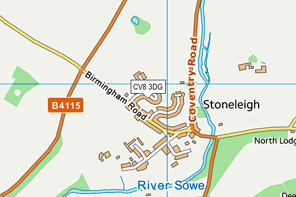
Stoneleigh Village Hall on a map

Stoneleigh Village Hall geodata
| Easting | 432795.8 |
| Northing | 272948.29 |
| Latitude | 52.353624 |
| Longitude | -1.519912 |
| Local Authority Name | Warwick |
| Local Authority Code | E07000222 |
| Parliamentary Constituency Name | Kenilworth and Southam |
| Parliamentary Constituency Code | E14000767 |
| Region Name | West Midlands |
| Region Code | E15000005 |
| Ward Name | Cubbington & Leek Wootton |
| Ward Code | E05012617 |
| Output Area Code | E00159644 |
About this data
This data is open data sourced from Active Places Power and licenced under the Active Places Open Data Licence.
| toid | osgb1000017000674 |
| Created On | 18th Sep 2017 |
| Audited On | 31st Oct 2022 |
| Checked On | 31st Oct 2022 |
