Soho Fitness (Closed) - Birmingham
Soho Fitness (Closed) is located in Birmingham (B21).
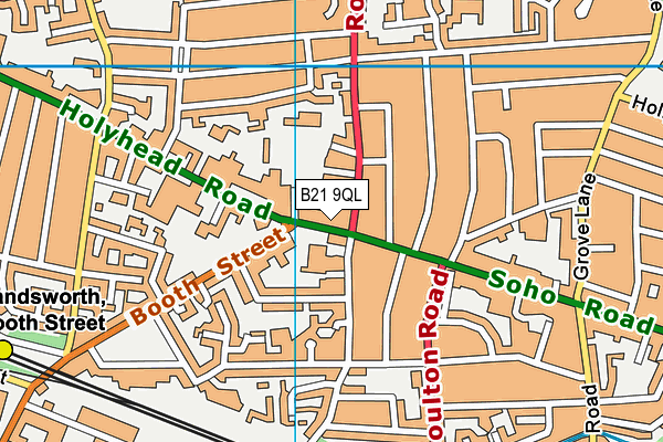
| Address | Second Floor, Piara Rayat House 366-372, Soho Road, Birmingham, B21 9QL |
| Car Park | Yes |
| Car Park Capacity | 12 |
| Management Type | Commercial Management |
| Management Group | Commercial |
| Owner Type | Commercial |
| Owner Group | Commercial |
| Education Phase | Not Known |
| Closure Date | 1st Apr 2016 |
| Closure Reason | Financial - insolvency, facilities uneconomic etc |
Facilities
| Closure Date | 1st Apr 2016 |
| Closure Reason | Financial - insolvency, facilities uneconomic etc |
| Accessibility | Pay and Play |
| Management Type | Commercial Management |
| Year Built | 1995 |
| Year Refurbished | 2003 |
| Changing Rooms | Yes |
| Year Changing Rooms Refurbished | 2005 |
| Date Record Checked | 13th Apr 2016 |
Opening times
| Access description | Pay and Play |
|---|
| Opening time | 10:00 |
| Closing time | 21:00 |
| Period open for | Every day |
Facility specifics
| Closure Date | 1st Apr 2016 |
| Closure Reason | Financial - insolvency, facilities uneconomic etc |
| Accessibility | Pay and Play |
| Management Type | Commercial Management |
| Year Built | 1995 |
| Year Refurbished | 2005 |
| Changing Rooms | Yes |
| Year Changing Rooms Refurbished | 2005 |
| Date Record Checked | 13th Apr 2016 |
Opening times
| Access description | Pay and Play |
|---|
| Opening time | 10:00 |
| Closing time | 21:00 |
| Period open for | Every day |
Facility specifics
| Area | 74.32m² |
| Floor Matting | Don't Know |
| Gymnastics Trampoline Use | Don't Know |
| Length | 0m |
| Moveable Balance Apparatus | Don't Know |
| Moveable Large Apparatus | Don't Know |
| Moveable Rebound Apparatus | Don't Know |
| Moveable Trampolines | Don't Know |
| Small Apparatus | Don't Know |
| Swinging and Hanging Apparatus | Don't Know |
| Width | 0m |
Contact
Disabled access
Disabled access for Soho Fitness (Closed)
Where is Soho Fitness (Closed)?
| Sub Building Name | Second Floor |
| Building Name | Piara Rayat House 366-372 |
| Building Number | 0 |
| Dependent Thoroughfare | |
| Thoroughfare Name | Soho Road |
| Double Dependent Locality | |
| Dependent Locality | |
| PostTown | Birmingham |
| Postcode | B21 9QL |
Soho Fitness (Closed) on a map

Soho Fitness (Closed) geodata
| Easting | 404028.4 |
| Northing | 289670.8 |
| Latitude | 52.50492 |
| Longitude | -1.942081 |
| Local Authority Name | Birmingham |
| Local Authority Code | E08000025 |
| Parliamentary Constituency Name | Birmingham, Perry Barr |
| Parliamentary Constituency Code | E14000566 |
| Region Name | West Midlands |
| Region Code | E15000005 |
| Ward Name | Handsworth |
| Ward Code | E05011142 |
| Output Area Code | E00046986 |
About this data
This data is open data sourced from Active Places Power and licenced under the Active Places Open Data Licence.
| Created On | 18th May 2004 |
| Audited On | 10th Apr 2015 |
| Checked On | 10th Apr 2015 |
