Powerleague (Shepherd's Bush) - London
Powerleague (Shepherd's Bush) is located in London (W12), and offers Artificial Grass Pitch.
| Address | 41, South Africa Road, London, W12 7RW |
| Management Type | Private Contractor (PPP/PFI) |
| Management Group | Others |
| Owner Type | Commercial |
| Owner Group | Commercial |
| Education Phase | Not applicable |
Aliases
Powerleague (Shepherd's Bush) is also known as:
- Hammersmith Park Football Centre
- Playfootball Shepherd's Bush
Facilities
| Accessibility | Sports Club / Community Association |
| Management Type | Private Contractor (PPP/PFI) |
| Year Built | 2016 |
| Changing Rooms | Yes |
| Date Record Created | 18th Mar 2016 |
| Date Record Checked | 20th Jun 2023 |
Opening times
| Access description | Sports Club / Community Association |
|---|
| Opening time | 09:00 |
| Closing time | 21:00 |
| Period open for | Monday-Friday |
| |
| Access description | Sports Club / Community Association |
|---|
| Opening time | 09:00 |
| Closing time | 20:00 |
| Period open for | Weekend |
Facility specifics
| Area | 600m² |
| Fill | Yes - Rubber |
| Floodlit | Yes |
| Indoor | No |
| Length | 30m |
| Pile Length | 40mm |
| Width | 20m |
| WR22 Compliant Pitch | No |
Disabled access
| Disabled Access | Yes |
| Disabled Parking | Yes |
| Finding/Reaching Entrance | Yes |
| Reception Area | Yes |
| Doorways | Yes |
| Disabled Changing Facilities | Yes |
| Activity Areas | Yes |
| Disabled Toilets | Yes |
| Social Areas | Yes |
| Spectator Areas | Yes |
| Emergency Exits | Yes |
Contact
Disabled access
Disabled access for Powerleague (Shepherd's Bush)
| Disabled Access | Yes |
| Disabled Parking | Yes |
| Finding/Reaching Entrance | Yes |
| Reception Area | Yes |
| Doorways | Yes |
| Disabled Changing Facilities | Yes |
| Activity Areas | Yes |
| Disabled Toilets | Yes |
| Social Areas | Yes |
| Spectator Areas | Yes |
| Emergency Exits | Yes |
Where is Powerleague (Shepherd's Bush)?
| Sub Building Name | |
| Building Name | |
| Building Number | 41 |
| Dependent Thoroughfare | |
| Thoroughfare Name | SOUTH AFRICA ROAD |
| Double Dependent Locality | |
| Dependent Locality | |
| PostTown | LONDON |
| Postcode | W12 7RW |
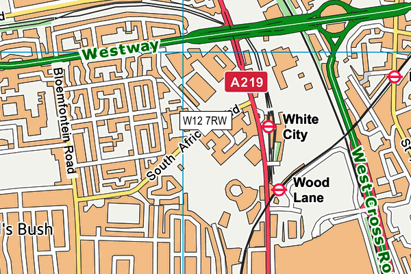
Powerleague (Shepherd's Bush) on a map

Powerleague (Shepherd's Bush) geodata
| Easting | 523014.79 |
| Northing | 180626.86 |
| Latitude | 51.511187 |
| Longitude | -0.228725 |
| Local Authority Name | Hammersmith and Fulham |
| Local Authority Code | E09000013 |
| Parliamentary Constituency Name | Hammersmith |
| Parliamentary Constituency Code | E14000726 |
| Region Name | London |
| Region Code | E15000007 |
| Ward Name | White City |
| Ward Code | E05013752 |
| Output Area Code | E00009730 |
About this data
This data is open data sourced from Active Places Power and licenced under the Active Places Open Data Licence.
| toid | osgb5000005185763885 |
| Created On | 18th Mar 2016 |
| Audited On | 20th Jun 2023 |
| Checked On | 20th Jun 2023 |
