Golf Kingdom - Romford
Golf Kingdom is located in Romford (RM6), and offers Golf.
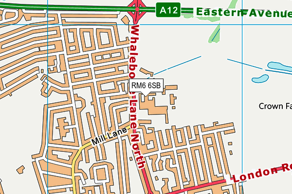
| Address | Whalebone Lane North, Romford, RM6 6SB |
| Car Park | Yes |
| Car Park Capacity | 80 |
| Management Type | Commercial Management |
| Management Group | Commercial |
| Owner Type | Commercial |
| Owner Group | Commercial |
| Education Phase | Not applicable |
Aliases
Golf Kingdom is also known as:
- Warren Park Golf Centre
- Cranfield Golf Centre
Facilities
| Accessibility | Pay and Play |
| Management Type | Commercial Management |
| Year Built | 1989 |
| Year Refurbished | 2017 |
| Changing Rooms | No |
| Date Record Checked | 27th Apr 2022 |
Opening times
| Access description | Pay and Play |
|---|
| Opening time | 09:00 |
| Closing time | 22:00 |
| Period open for | Monday-Friday |
| |
| Access description | Pay and Play |
|---|
| Opening time | 09:00 |
| Closing time | 20:00 |
| Period open for | Weekend |
Facility specifics
Disabled access
| Disabled Access | Yes |
| Disabled Parking | Yes |
| Finding/Reaching Entrance | Yes |
| Reception Area | Yes |
| Doorways | Yes |
| Activity Areas | Yes |
| Disabled Toilets | Yes |
| Social Areas | Yes |
| Spectator Areas | Yes |
| Emergency Exits | Yes |
| Accessibility | Pay and Play |
| Management Type | Commercial Management |
| Year Built | 2013 |
| Year Refurbished | 2017 |
| Changing Rooms | No |
| Date Record Checked | 27th Apr 2022 |
Opening times
| Access description | Pay and Play |
|---|
| Opening time | 09:00 |
| Closing time | 20:00 |
| Period open for | Weekend |
| |
| Access description | Pay and Play |
|---|
| Opening time | 09:00 |
| Closing time | 22:00 |
| Period open for | Monday-Friday |
Facility specifics
Disabled access
| Disabled Access | Yes |
| Disabled Parking | Yes |
| Finding/Reaching Entrance | Yes |
| Reception Area | Yes |
| Doorways | Yes |
| Activity Areas | Yes |
| Disabled Toilets | Yes |
| Social Areas | Yes |
| Spectator Areas | Yes |
| Emergency Exits | Yes |
Contact
Disabled access
Disabled access for Golf Kingdom
| Disabled Access | Yes |
| Disabled Parking | Yes |
| Finding/Reaching Entrance | Yes |
| Reception Area | Yes |
| Doorways | Yes |
| Activity Areas | Yes |
| Disabled Toilets | Yes |
| Social Areas | Yes |
| Spectator Areas | Yes |
| Emergency Exits | Yes |
Where is Golf Kingdom?
| Sub Building Name | |
| Building Name | |
| Building Number | 0 |
| Dependent Thoroughfare | |
| Thoroughfare Name | WHALEBONE LANE NORTH |
| Double Dependent Locality | |
| Dependent Locality | |
| PostTown | ROMFORD |
| Postcode | RM6 6SB |
Golf Kingdom on a map

Golf Kingdom geodata
| Easting | 548501.07 |
| Northing | 188764.8 |
| Latitude | 51.57819 |
| Longitude | 0.141716 |
| Local Authority Name | Barking and Dagenham |
| Local Authority Code | E09000002 |
| Parliamentary Constituency Name | Dagenham and Rainham |
| Parliamentary Constituency Code | E14000657 |
| Region Name | London |
| Region Code | E15000007 |
| Ward Name | Chadwell Heath |
| Ward Code | E05014058 |
| Output Area Code | E00000151 |
About this data
This data is open data sourced from Active Places Power and licenced under the Active Places Open Data Licence.
| toid | osgb1000000122380 |
| Created On | 31st Jan 2005 |
| Audited On | 27th Apr 2022 |
| Checked On | 27th Apr 2022 |
