Bexley College (Closed) - Belvedere
Bexley College (Closed) is located in Belvedere (DA17).
| Address | Tower Road, Belvedere, DA17 6HX |
| Car Park | Yes |
| Car Park Capacity | 100 |
| Management Type | School/College/University (in house) |
| Management Group | Education |
| Owner Type | Further Education |
| Owner Group | Education |
| Education Phase | 16 plus |
| Closure Date | 31st Jul 2014 |
| Closure Reason | Redevelopment - loss due to development project (e.g. major schemes such as HS2, new roads, area regeneration or smaller local development) |
Facilities
| Closure Date | 31st Jul 2014 |
| Closure Reason | Redevelopment - loss due to development project (e.g. major schemes such as HS2, new roads, area regeneration or smaller local development) |
| Accessibility | Private Use |
| Management Type | School/College/University (in house) |
| Changing Rooms | Yes |
| Date Record Created | 20th Jul 2016 |
| Date Record Checked | 12th Sep 2018 |
Opening times
| Access description | Private Use |
|---|
| Opening time | 13:00 |
| Closing time | 17:00 |
| Period open for | Monday |
| |
| Access description | Private Use |
|---|
| Opening time | 14:00 |
| Closing time | 18:00 |
| Period open for | Tuesday |
| |
| Access description | Private Use |
|---|
| Opening time | 12:00 |
| Closing time | 15:00 |
| Period open for | Wednesday |
| |
| Access description | Private Use |
|---|
| Opening time | 14:00 |
| Closing time | 17:00 |
| Period open for | Thursday |
| |
| Access description | Private Use |
|---|
| Opening time | 11:00 |
| Closing time | 14:00 |
| Period open for | Friday |
Facility specifics
Disabled access
| Disabled Access | Yes |
| Disabled Parking | Yes |
| Finding/Reaching Entrance | Yes |
| Reception Area | Yes |
| Doorways | Yes |
| Activity Areas | Yes |
| Disabled Toilets | Yes |
| Social Areas | Yes |
| Spectator Areas | Yes |
| Emergency Exits | Yes |
| Notes | 4 disabled parking bays. |
Contact
Disabled access
Disabled access for Bexley College (Closed)
| Disabled Access | Yes |
| Disabled Parking | Yes |
| Finding/Reaching Entrance | Yes |
| Reception Area | Yes |
| Doorways | Yes |
| Activity Areas | Yes |
| Disabled Toilets | Yes |
| Social Areas | Yes |
| Spectator Areas | Yes |
| Emergency Exits | Yes |
Where is Bexley College (Closed)?
| Sub Building Name | |
| Building Name | |
| Building Number | 0 |
| Dependent Thoroughfare | |
| Thoroughfare Name | TOWER ROAD |
| Double Dependent Locality | |
| Dependent Locality | |
| PostTown | BELVEDERE |
| Postcode | DA17 6HX |
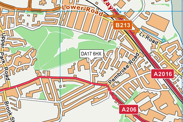
Bexley College (Closed) on a map

Bexley College (Closed) geodata
| Easting | 550315.66 |
| Northing | 178617.3 |
| Latitude | 51.486534 |
| Longitude | 0.163556 |
| Local Authority Name | Bexley |
| Local Authority Code | E09000004 |
| Parliamentary Constituency Name | Erith and Thamesmead |
| Parliamentary Constituency Code | E14000696 |
| Region Name | London |
| Region Code | E15000007 |
| Ward Name | Erith |
| Ward Code | E05011225 |
| Output Area Code | E00001992 |
About this data
This data is open data sourced from Active Places Power and licenced under the Active Places Open Data Licence.
| toid | osgb5000005164655291 |
| Created On | 20th Jul 2016 |
| Audited On | 6th Jul 2017 |
| Checked On | 24th Oct 2017 |
