Ashby Ivanhoe Fc - Ashby-de-la-zouch
Ashby Ivanhoe Fc is located in Ashby-de-la-zouch (LE65), and offers Grass Pitches.
| Address | NFU SPORTS GROUND, Lower Packington Road, Ashby-de-la-zouch, LE65 1TS |
| Car Park | Yes |
| Car Park Capacity | 75 |
| Management Type | Sport Club |
| Management Group | Others |
| Owner Type | Sports Club |
| Owner Group | Sports Club |
| Education Phase | Not applicable |
Aliases
Ashby Ivanhoe Fc is also known as:
- Nfu Sports Ground (Ashby-de-la-zouch)
Facilities
| Accessibility | Sports Club / Community Association |
| Management Type | Sport Club |
| Year Refurbished | 2015 |
| Changing Rooms | Yes |
| Date Record Created | 31st Mar 2016 |
| Date Record Checked | 24th Oct 2022 |
Opening times
| Access description | Sports Club / Community Association |
|---|
| Opening time | 08:00 |
| Closing time | 22:00 |
| Period open for | Every day |
Facility specifics
| Accessibility | Sports Club / Community Association |
| Management Type | Sport Club |
| Year Refurbished | 2015 |
| Changing Rooms | Yes |
| Date Record Created | 31st Mar 2016 |
| Date Record Checked | 24th Oct 2022 |
| Opening Times | Dawn To Dusk |
Facility specifics
| Accessibility | Sports Club / Community Association |
| Management Type | Sport Club |
| Year Refurbished | 2015 |
| Changing Rooms | Yes |
| Date Record Created | 31st Mar 2016 |
| Date Record Checked | 24th Oct 2022 |
| Opening Times | Dawn To Dusk |
Facility specifics
| Accessibility | Private Use |
| Management Type | Sport Club |
| Changing Rooms | Yes |
| Date Record Created | 24th Oct 2022 |
| Date Record Checked | 24th Oct 2022 |
| Opening Times | Dawn To Dusk |
Facility specifics
Contact
Where is Ashby Ivanhoe Fc?
| Sub Building Name | |
| Building Name | NFU SPORTS GROUND |
| Building Number | 0 |
| Dependent Thoroughfare | |
| Thoroughfare Name | LOWER PACKINGTON ROAD |
| Double Dependent Locality | |
| Dependent Locality | |
| PostTown | ASHBY-DE-LA-ZOUCH |
| Postcode | LE65 1TS |
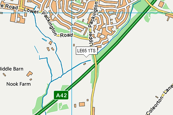
Ashby Ivanhoe Fc on a map

Ashby Ivanhoe Fc geodata
| Easting | 436019.22 |
| Northing | 315721.35 |
| Latitude | 52.73793 |
| Longitude | -1.467961 |
| Local Authority Name | North West Leicestershire |
| Local Authority Code | E07000134 |
| Parliamentary Constituency Name | North West Leicestershire |
| Parliamentary Constituency Code | E14000858 |
| Region Name | East Midlands |
| Region Code | E15000004 |
| Ward Name | Ashby Castle |
| Ward Code | E05010091 |
| Output Area Code | E00131511 |
About this data
This data is open data sourced from Active Places Power and licenced under the Active Places Open Data Licence.
| toid | osgb1000026016415 |
| Created On | 31st Mar 2016 |
| Audited On | 19th Oct 2022 |
| Checked On | 24th Oct 2022 |
