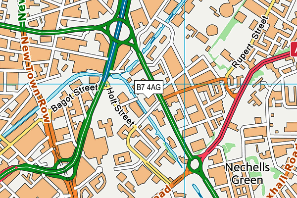
The National College for Advanced Transport and Infrastructure is located in Birmingham and falls under the local authority of Birmingham. This mixed-sex 16 plus school accepts pupils aged from nineteen up to ninety-nine, and the type of establishment is further education.
| Address | The National College for Advanced Transport and Infrastructure 2 Lister Street Birmingham B7 4AG |
| Website | http://www.ncati.ac.uk |
| Headteacher | Mr Ian Fitzpatrick |
GetTheData
Source: Get Information About Schools
Licence: Open Government Licence
| Phase of Education | 16 plus |
| Type of Establishment | Further education |
| Statutory Low Age | 19 |
| Statutory High Age | 99 |
| Official Sixth Form | Not applicable |
| Gender | Mixed |
| Religious Character | None |
| Diocese | Not applicable |
| Special Classes | Not applicable |
GetTheData
Source: Get Information About Schools
Licence: Open Government Licence
| Street Address | 2 Lister Street |
| Town | Birmingham |
| Postcode | B7 4AG |
| ➜ More B7 4AG open data | |
GetTheData
Source: Get Information About Schools
Licence: Open Government Licence

GetTheData
Source: OS VectorMap District (Ordnance Survey)
Licence: Open Government Licence (requires attribution)
| Ofsted Special Measures | Not applicable |
GetTheData
Source: Get Information About Schools
Licence: Open Government Licence
| Establishment Name | The National College for Advanced Transport and Infrastructure |
| Establishment Number | 8001 |
| Unique Reference Number | 148721 |
| Local Authority | Birmingham |
| Local Authority Code | 330 |
| Previous Local Authority Code | 999 |
| Government Statistical Service Local Authority Code | E08000025 |
| Government Office Region | West Midlands |
| District | Birmingham |
| District Code | E08000025 |
| Ward | Nechells |
| Parliamentary Constituency | Birmingham, Ladywood |
| Urban/Rural Description | (England/Wales) Urban major conurbation |
| Middle Super Output Area | Birmingham 050 |
| Lower Super Output Area | Birmingham 050E |
GetTheData
Source: Get Information About Schools
Licence: Open Government Licence
| Establishment Status | Open |
| Last Changed Date | 7th June 2021 |
| Reason Establishment Opened | Result of Amalgamation |
| Open Date | 1st May 2021 |
GetTheData
Source: Get Information About Schools
Licence: Open Government Licence
| Teenage Mothers | Not applicable |
| Special Educational Needs (SEN) Provision in Primary Care Unit | Not applicable |
| Pupil Referral Unit (PRU) Provides for Educational and Behavioural Difficulties (EBD) | Not applicable |
GetTheData
Source: Get Information About Schools
Licence: Open Government Licence
| Section 41 Approved | Not applicable |
GetTheData
Source: Get Information About Schools
Licence: Open Government Licence
| Trust flag | Not applicable |
| School Sponsor flag | Not applicable |
GetTheData
Source: Get Information About Schools
Licence: Open Government Licence
| Federation flag | Not applicable |
GetTheData
Source: Get Information About Schools
Licence: Open Government Licence
| UK Provider Reference Number | 10088193 |
| Further Education Type | General Further Education College |
GetTheData
Source: Get Information About Schools
Licence: Open Government Licence
| Easting | 407879 |
| Northing | 287839 |
| Latitude | 52.48841 |
| Longitude | -1.88539 |
GetTheData
Source: Get Information About Schools
Licence: Open Government Licence
| School | Phase of Education | Distance |
|---|---|---|
| Aston University Engineering Academy 1 Lister Street, Birmingham, B7 4AG | Secondary | 96m |
| Aston University Aston Triangle, Birmingham, B4 7ET | Not applicable | 426m |
| King Solomon International Business School Lord Street, Birmingham, B7 4AA | All-through | 462m |
| St Matthew's CofE Primary School Duddeston Manor Road, Nechells, Birmingham, B7 4JR | Primary | 492m |
| BOA Digital Technologies Academy 47 Barrack Street, Birmingham, B7 4EU | Secondary | 588m |
| Birmingham Ormiston Academy 1 Grosvenor Street, Birmingham, B4 7QD | Secondary | 630m |
| Birmingham Metropolitan College Jennens Road, Birmingham, B4 7PS | 16 plus | 634m |
| Heartlands Academy Great Francis Street, Nechells, Birmingham, B7 4QR | Secondary | 716m |
| Birmingham City University University House, 15 Bartholomew Row, Birmingham, B5 5JU | Not applicable | 729m |
| St Vincent's Catholic Primary School Vauxhall Grove, Vauxhall, St Vincent's Catholic Primary School, BIRMINGHAM, B7 4HP | Primary | 775m |
GetTheData
Source: Get Information About Schools
Licence: Open Government Licence