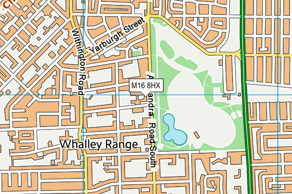
St Bede's College is located in Whalley Range and falls under the local authority of Manchester. The school's religious denomination is Roman Catholic. This mixed-sex school has 761 pupils, with a capacity of 1,145, aged from three up to nineteen, and the type of establishment is other independent school.
| Address | St Bede's College Alexandra Road South Whalley Range Manchester M16 8HX |
| Website | http://www.sbcm.co.uk |
| Headmaster | Mrs Maria Kemp |
GetTheData
Source: Get Information About Schools
Licence: Open Government Licence
| Phase of Education | Not applicable |
| Type of Establishment | Other independent school |
| Admissions Policy | Selective |
| Statutory Low Age | 3 |
| Statutory High Age | 19 |
| Boarders | No boarders |
| Boarding Establishment | Does not have boarders |
| Official Sixth Form | Has a sixth form |
| Gender | Mixed |
| Religious Character | Roman Catholic |
| Diocese | Not applicable |
| Special Classes | No Special Classes |
GetTheData
Source: Get Information About Schools
Licence: Open Government Licence
| Census Date | 20th January 2022 | |
| School Capacity | 1,145 | |
| Number of Pupils | 761 | 66% capacity |
| Number of Boys | 448 | 59% |
| Number of Girls | 313 | 41% |
| Free School Meals (%) | 0.0% |
GetTheData
Source: Get Information About Schools
Licence: Open Government Licence
| Street Address | Alexandra Road South |
| Locality | Whalley Range |
| Address 3 | Manchester |
| Postcode | M16 8HX |
| ➜ More M16 8HX open data | |
GetTheData
Source: Get Information About Schools
Licence: Open Government Licence

GetTheData
Source: OS VectorMap District (Ordnance Survey)
Licence: Open Government Licence (requires attribution)
| Ofsted Special Measures | Not applicable |
GetTheData
Source: Get Information About Schools
Licence: Open Government Licence
| Establishment Name | St Bede's College |
| Establishment Number | 6032 |
| Unique Reference Number | 105594 |
| Local Authority | Manchester |
| Local Authority Code | 352 |
| Previous Local Authority Code | 999 |
| Government Statistical Service Local Authority Code | E08000003 |
| Government Office Region | North West |
| District | Manchester |
| District Code | E08000003 |
| Ward | Whalley Range |
| Parliamentary Constituency | Manchester, Gorton |
| Urban/Rural Description | (England/Wales) Urban major conurbation |
| Middle Super Output Area | Manchester 028 |
| Lower Super Output Area | Manchester 028E |
GetTheData
Source: Get Information About Schools
Licence: Open Government Licence
| Establishment Status | Open |
| Last Changed Date | 24th November 2023 |
| Reason Establishment Opened | Not applicable |
| Open Date | 30th September 1980 |
| Reason Establishment Closed | Not applicable |
GetTheData
Source: Get Information About Schools
Licence: Open Government Licence
| Teenage Mothers | Not applicable |
| Child Care Facilities | Not applicable |
| Special Educational Needs (SEN) Provision in Primary Care Unit | Not applicable |
| Pupil Referral Unit (PRU) Provides for Educational and Behavioural Difficulties (EBD) | Not applicable |
| Pupil Referral Unit (PRU) Offers Tuition by Another Provider | Not applicable |
GetTheData
Source: Get Information About Schools
Licence: Open Government Licence
| Section 41 Approved | Not approved |
GetTheData
Source: Get Information About Schools
Licence: Open Government Licence
| Trust flag | Not applicable |
| School Sponsor flag | Not applicable |
GetTheData
Source: Get Information About Schools
Licence: Open Government Licence
| Federation flag | Not applicable |
GetTheData
Source: Get Information About Schools
Licence: Open Government Licence
| UK Provider Reference Number | 10017681 |
| Further Education Type | Not applicable |
GetTheData
Source: Get Information About Schools
Licence: Open Government Licence
| Easting | 383324 |
| Northing | 394987 |
| Latitude | 53.45137 |
| Longitude | -2.25258 |
GetTheData
Source: Get Information About Schools
Licence: Open Government Licence
| School | Phase of Education | Distance |
|---|---|---|
| St Margaret's CofE Primary School Withington Road, Whalley Range, Manchester, M16 8FQ | Primary | 458m |
| St Mary's CofE Junior and Infant School Adscombe Street, Alexandra Park, Moss Side, Manchester, M16 7AQ | Primary | 602m |
| William Hulme's Grammar School Spring Bridge Road, Manchester, M16 8PR | All-through | 673m |
| Kassim Darwish Grammar School for Boys Hartley Hall, Alexandra Road South, Chorlton-Cum-Hardy, Manchester, M16 8NH | Not applicable | 687m |
| Our Lady's RC Primary School Manchester Whalley Road, Whalley Range, Manchester, M16 8AW | Primary | 868m |
| IncludEd Learning 8 Alexandra Road South, Whalley Range, Manchester, M16 8ER | Not applicable | 922m |
| Manley Park Primary School College Road, Whalley Range, Manchester, M16 0AA | Primary | 1km |
| Whalley Range 11-18 High School Wilbraham Road, Whalley Range, Manchester, M16 8GW | Secondary | 1km |
| Wilbraham Primary School Platt Lane, Fallowfield, Manchester, M14 7FB | Primary | 1.2km |
| Claremont Primary School Claremont Road, Moss Side, Claremont Primary School, Manchester, M14 7NA | Primary | 1.2km |
GetTheData
Source: Get Information About Schools
Licence: Open Government Licence