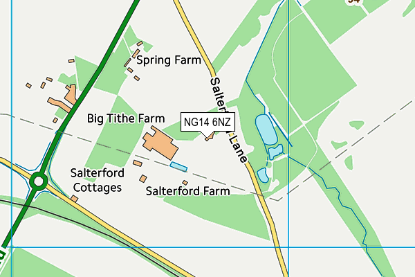
Salterford House School is located in Calverton, Nottingham and falls under the local authority of Nottinghamshire. This mixed-sex school has 93 pupils, with a capacity of 189, aged from two up to eleven, and the type of establishment is other independent school.
| Address | Salterford House School Salterford Lane Calverton Nottingham Nottinghamshire NG14 6NZ |
| Website | http://www.salterfordhouseschool.co.uk |
| Headteacher | Ms Kim Venables |
GetTheData
Source: Get Information About Schools
Licence: Open Government Licence
| Phase of Education | Not applicable |
| Type of Establishment | Other independent school |
| Admissions Policy | Non-selective |
| Statutory Low Age | 2 |
| Statutory High Age | 11 |
| Boarders | No boarders |
| Boarding Establishment | Does not have boarders |
| Official Sixth Form | Does not have a sixth form |
| Gender | Mixed |
| Religious Character | None |
| Diocese | Not applicable |
| Special Classes | No Special Classes |
GetTheData
Source: Get Information About Schools
Licence: Open Government Licence
| Census Date | 20th January 2022 | |
| School Capacity | 189 | |
| Number of Pupils | 93 | 49% capacity |
| Number of Boys | 47 | 51% |
| Number of Girls | 46 | 49% |
GetTheData
Source: Get Information About Schools
Licence: Open Government Licence
| Street Address | Salterford Lane |
| Locality | Calverton |
| Town | Nottingham |
| County | Nottinghamshire |
| Postcode | NG14 6NZ |
| ➜ More NG14 6NZ open data | |
GetTheData
Source: Get Information About Schools
Licence: Open Government Licence

GetTheData
Source: OS VectorMap District (Ordnance Survey)
Licence: Open Government Licence (requires attribution)
| Ofsted Special Measures | Not applicable |
GetTheData
Source: Get Information About Schools
Licence: Open Government Licence
| Establishment Name | Salterford House School |
| Establishment Number | 6017 |
| Previous Establishment Number | 6074 |
| Unique Reference Number | 122938 |
| Local Authority | Nottinghamshire |
| Local Authority Code | 891 |
| Previous Local Authority | Pre LGR (1998) Nottinghamshire |
| Previous Local Authority Code | 930 |
| Government Statistical Service Local Authority Code | E10000024 |
| Government Office Region | East Midlands |
| District | Gedling |
| District Code | E07000173 |
| Ward | Calverton |
| Parliamentary Constituency | Sherwood |
| Urban/Rural Description | (England/Wales) Rural hamlet and isolated dwellings |
| Middle Super Output Area | Gedling 002 |
| Lower Super Output Area | Gedling 002C |
GetTheData
Source: Get Information About Schools
Licence: Open Government Licence
| Establishment Status | Open |
| Last Changed Date | 26th September 2023 |
| Reason Establishment Opened | Not applicable |
| Open Date | 5th March 1982 |
| Reason Establishment Closed | Not applicable |
GetTheData
Source: Get Information About Schools
Licence: Open Government Licence
| Teenage Mothers | Not applicable |
| Child Care Facilities | Not applicable |
| Special Educational Needs (SEN) Provision in Primary Care Unit | Not applicable |
| Pupil Referral Unit (PRU) Provides for Educational and Behavioural Difficulties (EBD) | Not applicable |
| Pupil Referral Unit (PRU) Offers Tuition by Another Provider | Not applicable |
GetTheData
Source: Get Information About Schools
Licence: Open Government Licence
| Section 41 Approved | Not approved |
GetTheData
Source: Get Information About Schools
Licence: Open Government Licence
| Trust flag | Not applicable |
| School Sponsor flag | Not applicable |
GetTheData
Source: Get Information About Schools
Licence: Open Government Licence
| Federation flag | Not applicable |
GetTheData
Source: Get Information About Schools
Licence: Open Government Licence
| UK Provider Reference Number | 10071100 |
| Further Education Type | Not applicable |
GetTheData
Source: Get Information About Schools
Licence: Open Government Licence
| Easting | 460709 |
| Northing | 352390 |
| Latitude | 53.06531 |
| Longitude | -1.09549 |
GetTheData
Source: Get Information About Schools
Licence: Open Government Licence
| School | Phase of Education | Distance |
|---|---|---|
| Sir John Sherbrooke Junior School Flatts Lane, Calverton, Nottingham, NG14 6JZ | Primary | 2.7km |
| Colonel Frank Seely Academy Flatts Lane, Calverton, Nottingham, NG14 6JZ | Secondary | 2.8km |
| Manor Park Infant and Nursery School Flatts Lane, Calverton, Nottingham, NG14 6JZ | Primary | 2.9km |
| Burntstump Seely CofE Primary Academy Burntstump Hill, Arnold, Nottingham, NG5 8PQ | Primary | 3km |
| St Wilfrid's CofE Primary School Main Street, Calverton, Nottingham, NG14 6FG | Primary | 3.4km |
| R.E.A.L Independent Schools Blidworth The Old Fire Station, Mansfield Road, Blidworth, NG21 0PN | Not applicable | 4km |
| Blidworth Oaks Primary School Haywood Avenue, Blidworth, Blidworth Oaks Primary School, Mansfield, NG21 0RE | Primary | 4.3km |
| Abbey Gates Primary School Vernon Crescent, Ravenshead, Nottingham, NG15 9BN | Primary | 5.1km |
| Ravenshead CofE Primary School Swinton Rise, Ravenshead, Nottingham, NG15 9FS | Primary | 5.2km |
| Wood's Foundation CofE Primary School Lingwood Lane, Woodborough, Nottingham, NG14 6DX | Primary | 5.4km |
GetTheData
Source: Get Information About Schools
Licence: Open Government Licence