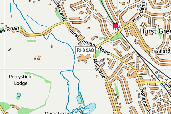
Moor House School & College is located in Hurst Green, Oxted and falls under the local authority of Surrey. This mixed-sex school has 208 pupils, with a capacity of 220, aged from seven up to nineteen, and the type of establishment is non-maintained special school. The most recend Ofsted inspection was 30th November 2022 resulting in an outstanding rating.
| Address | Moor House School & College Mill Lane Hurst Green Oxted Surrey RH8 9AQ |
| Website | http://www.moorhouseschool.co.uk |
| Headteacher | Mrs Helen Middleton |
GetTheData
Source: Get Information About Schools
Licence: Open Government Licence
| Phase of Education | Not applicable |
| Type of Establishment | Non-maintained special school |
| Admissions Policy | Not applicable |
| Statutory Low Age | 7 |
| Statutory High Age | 19 |
| Boarders | Boarding school |
| Boarding Establishment | Has boarders |
| Official Sixth Form | Has a sixth form |
| Gender | Mixed |
| Religious Character | Does not apply |
| Diocese | Not applicable |
| Special Classes | Has Special Classes |
GetTheData
Source: Get Information About Schools
Licence: Open Government Licence
| Census Date | 19th January 2023 | |
| School Capacity | 220 | |
| Number of Pupils | 208 | 95% capacity |
| Number of Boys | 137 | 66% |
| Number of Girls | 71 | 34% |
| Free School Meals (%) | 2.90% |
GetTheData
Source: Get Information About Schools
Licence: Open Government Licence
| Street Address | Mill Lane |
| Locality | Hurst Green |
| Town | Oxted |
| County | Surrey |
| Postcode | RH8 9AQ |
| ➜ More RH8 9AQ open data | |
GetTheData
Source: Get Information About Schools
Licence: Open Government Licence

GetTheData
Source: OS VectorMap District (Ordnance Survey)
Licence: Open Government Licence (requires attribution)
| Ofsted Last Inspection | 30th November 2022 |
| Ofsted Rating | Outstanding |
| Ofsted Special Measures | Not applicable |
GetTheData
Source: Get Information About Schools
Licence: Open Government Licence
| Establishment Name | Moor House School & College |
| Establishment Number | 7007 |
| Unique Reference Number | 125454 |
| Local Authority | Surrey |
| Local Authority Code | 936 |
| Previous Local Authority Code | 999 |
| Government Statistical Service Local Authority Code | E10000030 |
| Government Office Region | South East |
| District | Tandridge |
| District Code | E07000215 |
| Ward | Oxted South |
| Parliamentary Constituency | East Surrey |
| Urban/Rural Description | (England/Wales) Urban city and town |
| Middle Super Output Area | Tandridge 007 |
| Lower Super Output Area | Tandridge 007D |
GetTheData
Source: Get Information About Schools
Licence: Open Government Licence
| Establishment Status | Open |
| Last Changed Date | 24th January 2024 |
| Reason Establishment Opened | Not applicable |
| Reason Establishment Closed | Not applicable |
GetTheData
Source: Get Information About Schools
Licence: Open Government Licence
| Teenage Mothers | Not applicable |
| Child Care Facilities | Not applicable |
| Special Educational Needs (SEN) Provision in Primary Care Unit | Not applicable |
| Pupil Referral Unit (PRU) Provides for Educational and Behavioural Difficulties (EBD) | Not applicable |
| Pupil Referral Unit (PRU) Offers Tuition by Another Provider | Not applicable |
GetTheData
Source: Get Information About Schools
Licence: Open Government Licence
| Section 41 Approved | Not applicable |
| Special Educational Needs (SEN) Priority 1 | SLCN - Speech, language and Communication |
GetTheData
Source: Get Information About Schools
Licence: Open Government Licence
| Trust flag | Not applicable |
| School Sponsor flag | Not applicable |
GetTheData
Source: Get Information About Schools
Licence: Open Government Licence
| Federation flag | Not applicable |
GetTheData
Source: Get Information About Schools
Licence: Open Government Licence
| UK Provider Reference Number | 10016541 |
| Further Education Type | Not applicable |
GetTheData
Source: Get Information About Schools
Licence: Open Government Licence
| Easting | 539716 |
| Northing | 151111 |
| Latitude | 51.24207 |
| Longitude | 0.0002 |
GetTheData
Source: Get Information About Schools
Licence: Open Government Licence
| School | Phase of Education | Distance |
|---|---|---|
| Hurst Green Infant School Wolfs Wood, Hurst Green, Oxted, RH8 0HJ | Primary | 632m |
| Hazelwood School Wolfs Hill, Limpsfield, Oxted, RH8 0QU | Not applicable | 1km |
| Holland Junior School Holland Road, Hurst Green, Oxted, RH8 9BQ | Primary | 1.1km |
| Oxted School Bluehouse Lane, Oxted, RH8 0AB | Secondary | 2km |
| Limpsfield CofE Infant School Limpsfield Common, Westerham Road, Oxted, RH8 0EA | Primary | 2.1km |
| St Mary's CofE Primary School Silkham Road, Oxted, RH8 0NP | Primary | 2.4km |
| St Peter's CofE Infant School Tandridge Lane, Tandridge, Oxted, RH8 9NN | Primary | 2.5km |
| Limpsfield Grange School 89 Bluehouse Lane, Oxted, RH8 0RZ | Not applicable | 2.6km |
| St Stephen's CofE Primary School Hunters Chase, South Godstone, Godstone, RH9 8HR | Primary | 4km |
| Crockham Hill Church of England Voluntary Controlled Primary School Crockham Hill, Edenbridge, TN8 6RP | Primary | 4.7km |
GetTheData
Source: Get Information About Schools
Licence: Open Government Licence