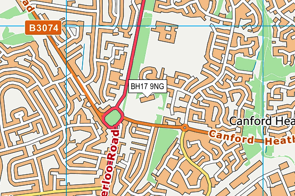
Montacute School is located in Poole and falls under the local authority of Bournemouth, Christchurch and Poole. This mixed-sex school has 90 pupils, with a capacity of 88, aged from two up to eighteen, and the type of establishment is academy special converter. The most recend Ofsted inspection was 29th March 2023 resulting in an good rating.
| Address | Montacute School 3 Canford Heath Road Poole Dorset BH17 9NG |
| Website | http://www.montacute.poole.sch.uk |
| Headteacher | Mrs Ginny Bellard |
GetTheData
Source: Get Information About Schools
Licence: Open Government Licence
| Phase of Education | Not applicable |
| Type of Establishment | Academy special converter |
| Admissions Policy | Not applicable |
| Statutory Low Age | 2 |
| Statutory High Age | 18 |
| Boarders | No boarders |
| Official Sixth Form | Has a sixth form |
| Gender | Mixed |
| Religious Character | Does not apply |
| Diocese | Not applicable |
| Special Classes | Has Special Classes |
GetTheData
Source: Get Information About Schools
Licence: Open Government Licence
| Census Date | 19th January 2023 | |
| School Capacity | 88 | |
| Number of Pupils | 90 | 102% capacity |
| Number of Boys | 63 | 70% |
| Number of Girls | 27 | 30% |
| Free School Meals (%) | 39.50% |
GetTheData
Source: Get Information About Schools
Licence: Open Government Licence
| Street Address | 3 Canford Heath Road |
| Town | Poole |
| County | Dorset |
| Postcode | BH17 9NG |
| ➜ More BH17 9NG open data | |
GetTheData
Source: Get Information About Schools
Licence: Open Government Licence

GetTheData
Source: OS VectorMap District (Ordnance Survey)
Licence: Open Government Licence (requires attribution)
| Ofsted Last Inspection | 29th March 2023 |
| Ofsted Rating | Good |
| Ofsted Special Measures | Not applicable |
GetTheData
Source: Get Information About Schools
Licence: Open Government Licence
| Establishment Name | Montacute School |
| Establishment Number | 5951 |
| Unique Reference Number | 137286 |
| Local Authority | Bournemouth, Christchurch and Poole |
| Local Authority Code | 839 |
| Previous Local Authority | Pre-LGR 2019 Poole |
| Previous Local Authority Code | 836 |
| Government Statistical Service Local Authority Code | X999999 |
| Government Office Region | South West |
| District | Bournemouth, Christchurch and Poole |
| District Code | E06000058 |
| Ward | Canford Heath |
| Parliamentary Constituency | Mid Dorset and North Poole |
| Urban/Rural Description | (England/Wales) Urban city and town |
| Middle Super Output Area | Bournemouth, Christchurch and Poole 013 |
| Lower Super Output Area | Bournemouth, Christchurch and Poole 013C |
GetTheData
Source: Get Information About Schools
Licence: Open Government Licence
| Establishment Status | Open |
| Last Changed Date | 27th November 2023 |
| Reason Establishment Opened | Academy Converter |
| Open Date | 1st October 2011 |
GetTheData
Source: Get Information About Schools
Licence: Open Government Licence
| Teenage Mothers | Not applicable |
| Child Care Facilities | Not applicable |
| Special Educational Needs (SEN) Provision in Primary Care Unit | Not applicable |
| Pupil Referral Unit (PRU) Provides for Educational and Behavioural Difficulties (EBD) | Not applicable |
| Pupil Referral Unit (PRU) Offers Tuition by Another Provider | Not applicable |
GetTheData
Source: Get Information About Schools
Licence: Open Government Licence
| Section 41 Approved | Not applicable |
| Special Educational Needs (SEN) Priority 1 | ASD - Autistic Spectrum Disorder |
| Special Educational Needs (SEN) Priority 2 | SLD - Severe Learning Difficulty |
GetTheData
Source: Get Information About Schools
Licence: Open Government Licence
| Trust flag | Supported by a single-academy trust |
| Trust | MONTACUTE SCHOOL |
| School Sponsor flag | - |
GetTheData
Source: Get Information About Schools
Licence: Open Government Licence
| Federation flag | Not applicable |
GetTheData
Source: Get Information About Schools
Licence: Open Government Licence
| UK Provider Reference Number | 10035068 |
| Further Education Type | Not applicable |
GetTheData
Source: Get Information About Schools
Licence: Open Government Licence
| Easting | 401427 |
| Northing | 94587 |
| Latitude | 50.75088 |
| Longitude | -1.98114 |
GetTheData
Source: Get Information About Schools
Licence: Open Government Licence
| School | Phase of Education | Distance |
|---|---|---|
| Poole Grammar School Gravel Hill, Poole, BH17 9JU | Secondary | 422m |
| Parkstone Grammar School Sopers Lane, Poole, BH17 7EP | Secondary | 686m |
| Hillbourne Primary School Kitchener Crescent, Poole, BH17 7HX | Primary | 819m |
| Haymoor Junior School Ashdown Close, Canford Heath, Poole, BH17 8WG | Primary | 1km |
| Magna Academy Ashdown Close, Adastral Road, Canford Heath, Poole, BH17 8RE | Secondary | 1.1km |
| Ad Astra Infant School Sherborn Crescent, Canford Heath, Poole, BH17 8AP | Primary | 1.1km |
| Longspee Academy Learoyd Road, Canford Heath, Poole, BH17 8PJ | Not applicable | 1.3km |
| Canford Heath Junior School Learoyd Road, Canford Heath, Poole, BH17 8PJ | Primary | 1.4km |
| Canford Heath Infant School Learoyd Road, Canford Heath, Poole, BH17 8PJ | Primary | 1.4km |
| Broadstone Middle School Dunyeats Road, Broadstone, BH18 8AE | Middle deemed secondary | 1.5km |
GetTheData
Source: Get Information About Schools
Licence: Open Government Licence