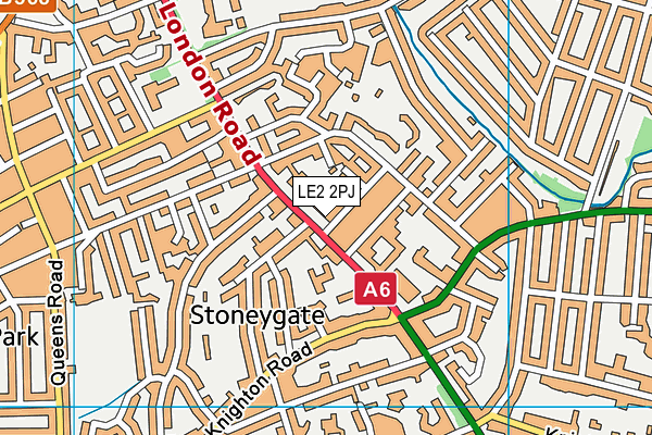
Leicester Islamic Academy is located in Leicester and falls under the local authority of Leicester. The school's religious denomination is Islam. This mixed-sex school has 326 pupils, with a capacity of 450, aged from three up to eleven, and the type of establishment is other independent school. The most recend Ofsted inspection was 24th February 2022 resulting in an good rating.
| Address | Leicester Islamic Academy 320 London Road Leicester Leicestershire LE2 2PJ |
| Website | http://www.lia.uk.net |
| Headteacher | Mrs Tabassum Jakhura |
GetTheData
Source: Get Information About Schools
Licence: Open Government Licence
| Phase of Education | Not applicable |
| Type of Establishment | Other independent school |
| Admissions Policy | Non-selective |
| Statutory Low Age | 3 |
| Statutory High Age | 11 |
| Boarders | No boarders |
| Boarding Establishment | Does not have boarders |
| Official Sixth Form | Does not have a sixth form |
| Gender | Mixed |
| Religious Character | Islam |
| Diocese | Not applicable |
| Special Classes | No Special Classes |
GetTheData
Source: Get Information About Schools
Licence: Open Government Licence
| Census Date | 20th January 2022 | |
| School Capacity | 450 | |
| Number of Pupils | 326 | 72% capacity |
| Number of Boys | 170 | 52% |
| Number of Girls | 156 | 48% |
GetTheData
Source: Get Information About Schools
Licence: Open Government Licence
| Street Address | 320 London Road |
| Town | Leicester |
| County | Leicestershire |
| Postcode | LE2 2PJ |
| ➜ More LE2 2PJ open data | |
GetTheData
Source: Get Information About Schools
Licence: Open Government Licence

GetTheData
Source: OS VectorMap District (Ordnance Survey)
Licence: Open Government Licence (requires attribution)
| Ofsted Last Inspection | 24th February 2022 |
| Ofsted Rating | Good |
| Ofsted Special Measures | Not applicable |
GetTheData
Source: Get Information About Schools
Licence: Open Government Licence
| Establishment Name | Leicester Islamic Academy |
| Establishment Number | 6007 |
| Previous Establishment Number | 6236 |
| Unique Reference Number | 120335 |
| Local Authority | Leicester |
| Local Authority Code | 856 |
| Previous Local Authority | Pre LGR (1997) Leicestershire |
| Previous Local Authority Code | 924 |
| Government Statistical Service Local Authority Code | E06000016 |
| Government Office Region | East Midlands |
| District | Leicester |
| District Code | E06000016 |
| Ward | Knighton |
| Parliamentary Constituency | Leicester South |
| Urban/Rural Description | (England/Wales) Urban city and town |
| Middle Super Output Area | Leicester 030 |
| Lower Super Output Area | Leicester 030G |
GetTheData
Source: Get Information About Schools
Licence: Open Government Licence
| Establishment Status | Open |
| Last Changed Date | 28th November 2023 |
| Reason Establishment Opened | Not applicable |
| Open Date | 29th September 1982 |
| Reason Establishment Closed | Not applicable |
GetTheData
Source: Get Information About Schools
Licence: Open Government Licence
| Teenage Mothers | Not applicable |
| Child Care Facilities | Not applicable |
| Special Educational Needs (SEN) Provision in Primary Care Unit | Not applicable |
| Pupil Referral Unit (PRU) Provides for Educational and Behavioural Difficulties (EBD) | Not applicable |
| Pupil Referral Unit (PRU) Offers Tuition by Another Provider | Not applicable |
GetTheData
Source: Get Information About Schools
Licence: Open Government Licence
| Section 41 Approved | Not approved |
GetTheData
Source: Get Information About Schools
Licence: Open Government Licence
| Trust flag | Not applicable |
| School Sponsor flag | Not applicable |
GetTheData
Source: Get Information About Schools
Licence: Open Government Licence
| Federation flag | Not applicable |
GetTheData
Source: Get Information About Schools
Licence: Open Government Licence
| UK Provider Reference Number | 10016249 |
| Further Education Type | Not applicable |
GetTheData
Source: Get Information About Schools
Licence: Open Government Licence
| Easting | 460505 |
| Northing | 302546 |
| Latitude | 52.61733 |
| Longitude | -1.10776 |
GetTheData
Source: Get Information About Schools
Licence: Open Government Licence
| School | Phase of Education | Distance |
|---|---|---|
| Leicester Preparatory School 2 Albert Road, Stoneygate, Leicester, LE2 2AA | Not applicable | 133m |
| St John the Baptist CofE Primary School East Avenue, Leicester, LE2 1TE | Primary | 425m |
| St Crispin's School 6 St Mary's Road, Leicester, LE2 1XA | Not applicable | 657m |
| St Thomas More Catholic Voluntary Academy Newstead Road, Leicester, LE2 3TA | Primary | 688m |
| Avenue Primary School Avenue Road Extension, Leicester, LE2 3EJ | Primary | 818m |
| Land of Learning Primary School 5-11, Evington Drive, Leicester, LE5 5PF | Not applicable | 905m |
| Evington Valley Primary School Evington Valley Road, Leicester, LE5 5LL | Primary | 970m |
| Leicester Partnership School Carisbrooke Gardens, Leicester, LE2 3PR | Not applicable | 986m |
| WQE and Regent College Group University Road, Leicester, LE1 7RJ | 16 plus | 1.1km |
| Leicester High School for Girls 454 London Road, Leicester, LE2 2PP | Not applicable | 1.1km |
GetTheData
Source: Get Information About Schools
Licence: Open Government Licence