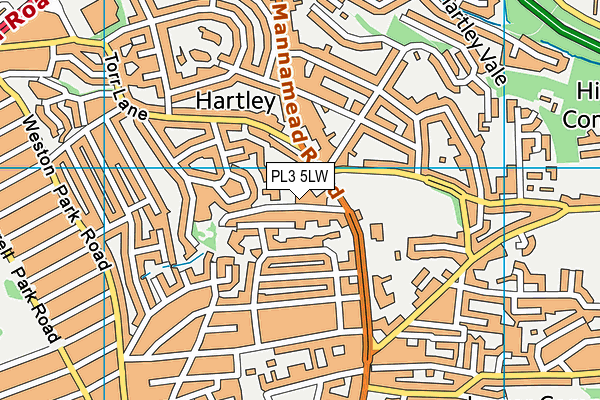
King's School is located in Mannamead, Plymouth and falls under the local authority of Plymouth. The school's religious denomination is Christian. This mixed-sex school has 306 pupils, with a capacity of 230, aged from two up to eleven, and the type of establishment is other independent school.
| Address | King's School Hartley Road Mannamead Plymouth Devon PL3 5LW |
| Website | http://www.kingsschool-plymouth.co.uk |
| Headteacher | Mrs Clare Page |
GetTheData
Source: Get Information About Schools
Licence: Open Government Licence
| Phase of Education | Not applicable |
| Type of Establishment | Other independent school |
| Admissions Policy | Non-selective |
| Statutory Low Age | 2 |
| Statutory High Age | 11 |
| Boarders | No boarders |
| Boarding Establishment | Does not have boarders |
| Official Sixth Form | Does not have a sixth form |
| Gender | Mixed |
| Religious Character | Christian |
| Diocese | Not applicable |
| Special Classes | No Special Classes |
GetTheData
Source: Get Information About Schools
Licence: Open Government Licence
| Census Date | 20th January 2022 | |
| School Capacity | 230 | |
| Number of Pupils | 306 | 133% capacity |
| Number of Boys | 148 | 48% |
| Number of Girls | 158 | 52% |
| Free School Meals (%) | 0.0% |
GetTheData
Source: Get Information About Schools
Licence: Open Government Licence
| Street Address | Hartley Road |
| Locality | Mannamead |
| Town | Plymouth |
| County | Devon |
| Postcode | PL3 5LW |
| ➜ More PL3 5LW open data | |
GetTheData
Source: Get Information About Schools
Licence: Open Government Licence

GetTheData
Source: OS VectorMap District (Ordnance Survey)
Licence: Open Government Licence (requires attribution)
| Ofsted Special Measures | Not applicable |
GetTheData
Source: Get Information About Schools
Licence: Open Government Licence
| Establishment Name | King's School |
| Establishment Number | 6002 |
| Previous Establishment Number | 6093 |
| Unique Reference Number | 113595 |
| Local Authority | Plymouth |
| Local Authority Code | 879 |
| Previous Local Authority | Pre LGR (1998) Devon |
| Previous Local Authority Code | 911 |
| Government Statistical Service Local Authority Code | E06000026 |
| Government Office Region | South West |
| District | Plymouth |
| District Code | E06000026 |
| Ward | Compton |
| Parliamentary Constituency | Plymouth, Sutton and Devonport |
| Urban/Rural Description | (England/Wales) Urban city and town |
| Middle Super Output Area | Plymouth 016 |
| Lower Super Output Area | Plymouth 016B |
GetTheData
Source: Get Information About Schools
Licence: Open Government Licence
| Establishment Status | Open |
| Last Changed Date | 28th November 2023 |
| Reason Establishment Opened | Not applicable |
| Open Date | 7th January 1958 |
| Reason Establishment Closed | Not applicable |
GetTheData
Source: Get Information About Schools
Licence: Open Government Licence
| Teenage Mothers | Not applicable |
| Child Care Facilities | Not applicable |
| Special Educational Needs (SEN) Provision in Primary Care Unit | Not applicable |
| Pupil Referral Unit (PRU) Provides for Educational and Behavioural Difficulties (EBD) | Not applicable |
| Pupil Referral Unit (PRU) Offers Tuition by Another Provider | Not applicable |
GetTheData
Source: Get Information About Schools
Licence: Open Government Licence
| Section 41 Approved | Not approved |
GetTheData
Source: Get Information About Schools
Licence: Open Government Licence
| Trust flag | Not applicable |
| School Sponsor flag | Not applicable |
GetTheData
Source: Get Information About Schools
Licence: Open Government Licence
| Federation flag | Not applicable |
GetTheData
Source: Get Information About Schools
Licence: Open Government Licence
| UK Provider Reference Number | 10071143 |
| Further Education Type | Not applicable |
GetTheData
Source: Get Information About Schools
Licence: Open Government Licence
| Easting | 248258 |
| Northing | 56876 |
| Latitude | 50.39213 |
| Longitude | -4.13611 |
GetTheData
Source: Get Information About Schools
Licence: Open Government Licence
| School | Phase of Education | Distance |
|---|---|---|
| Hyde Park Junior School Hyde Park Road, Mutley, Plymouth, PL3 4RH | Primary | 724m |
| Hyde Park Infants' School Hyde Park Road, Mutley, Plymouth, PL3 4RS | Primary | 748m |
| Compton CofE Primary School Higher Compton Road, Plymouth, PL3 5JB | Primary | 766m |
| Plymouth College Ford Park, Plymouth, PL4 6RN | Not applicable | 820m |
| Devonport High School for Girls Lyndhurst Road, Peverell, Plymouth, PL2 3DL | Secondary | 1.1km |
| Manadon Vale Primary School St Peter's Road, Manadon, Plymouth, PL5 3DL | Primary | 1.1km |
| Pennycross Primary School Arden Grove, Pennycross, Plymouth, PL2 3RL | Primary | 1.3km |
| Eggbuckland Community College Westcott Close, Eggbuckland, Plymouth, PL6 5YB | Secondary | 1.3km |
| Montpelier Primary School North Down Road, Beacon Park, Plymouth, PL2 3HN | Primary | 1.3km |
| Courtlands School Widey Lane, Crownhill, Plymouth, PL6 5JS | Not applicable | 1.3km |
GetTheData
Source: Get Information About Schools
Licence: Open Government Licence