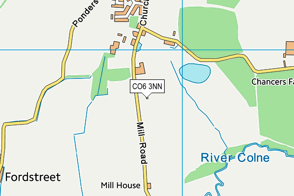
Fordham All Saints CofE Voluntary Controlled Primary School is located in Fordham, Colchester and falls under the local authority of Essex. The school's religious denomination is Church of England. This mixed-sex primary school has a capacity of 115 pupils, aged from four up to eleven, and the type of establishment is academy sponsor led.
| Address | Fordham All Saints CofE Voluntary Controlled Primary School Mill Road Fordham Colchester CO6 3NN |
| Headteacher | Mrs Ceri Daniels |
GetTheData
Source: Get Information About Schools
Licence: Open Government Licence
| Phase of Education | Primary |
| Type of Establishment | Academy sponsor led |
| Admissions Policy | Not applicable |
| Statutory Low Age | 4 |
| Statutory High Age | 11 |
| Boarders | No boarders |
| Official Sixth Form | Does not have a sixth form |
| Gender | Mixed |
| Religious Character | Church of England |
| Diocese | Diocese of Chelmsford |
GetTheData
Source: Get Information About Schools
Licence: Open Government Licence
| School Capacity | 115 |
GetTheData
Source: Get Information About Schools
Licence: Open Government Licence
| Street Address | Mill Road |
| Locality | Fordham |
| Town | Colchester |
| Postcode | CO6 3NN |
| ➜ More CO6 3NN open data | |
GetTheData
Source: Get Information About Schools
Licence: Open Government Licence

GetTheData
Source: OS VectorMap District (Ordnance Survey)
Licence: Open Government Licence (requires attribution)
| Ofsted Special Measures | Not applicable |
GetTheData
Source: Get Information About Schools
Licence: Open Government Licence
| Establishment Name | Fordham All Saints CofE Voluntary Controlled Primary School |
| Establishment Number | 2190 |
| Unique Reference Number | 150124 |
| Local Authority | Essex |
| Local Authority Code | 881 |
| Previous Local Authority Code | 999 |
| Government Statistical Service Local Authority Code | E10000012 |
| Government Office Region | East of England |
| District | Colchester |
| District Code | E07000071 |
| Ward | Rural North |
| Parliamentary Constituency | Harwich and North Essex |
| Urban/Rural Description | (England/Wales) Rural village |
| Middle Super Output Area | Colchester 003 |
| Lower Super Output Area | Colchester 003A |
GetTheData
Source: Get Information About Schools
Licence: Open Government Licence
| Establishment Status | Open |
| Last Changed Date | 1st November 2023 |
| Reason Establishment Opened | New Provision |
| Open Date | 1st November 2023 |
GetTheData
Source: Get Information About Schools
Licence: Open Government Licence
| Teenage Mothers | Not applicable |
| Special Educational Needs (SEN) Provision in Primary Care Unit | Not applicable |
| Pupil Referral Unit (PRU) Provides for Educational and Behavioural Difficulties (EBD) | Not applicable |
GetTheData
Source: Get Information About Schools
Licence: Open Government Licence
| Section 41 Approved | Not applicable |
GetTheData
Source: Get Information About Schools
Licence: Open Government Licence
| Trust flag | Supported by a multi-academy trust |
| Trust | LIFE EDUCATION TRUST |
| School Sponsor flag | Linked to a sponsor |
| School Sponsor | Life Education Trust |
GetTheData
Source: Get Information About Schools
Licence: Open Government Licence
| Federation flag | Not applicable |
GetTheData
Source: Get Information About Schools
Licence: Open Government Licence
| UK Provider Reference Number | 10093295 |
GetTheData
Source: Get Information About Schools
Licence: Open Government Licence
| Easting | 592774 |
| Northing | 227901 |
| Latitude | 51.91626 |
| Longitude | 0.8016 |
GetTheData
Source: Get Information About Schools
Licence: Open Government Licence
| School | Phase of Education | Distance |
|---|---|---|
| Holy Trinity CofE Primary School, Eight Ash Green and Aldham Fiddlers Folley, Fordham Heath, Colchester, CO3 9UE | Primary | 1.7km |
| Doucecroft School Abbotts Lane, Eight Ash Green, Colchester, CO6 3QL | Not applicable | 3km |
| Heathlands Church of England Voluntary Controlled Primary School, West Bergholt New Church Road, West Bergholt, Colchester, CO6 3JF | Primary | 3.3km |
| Chappel CofE Controlled Primary School The Street, Chappel, Colchester, CO6 2DD | Primary | 3.3km |
| Holmwood House School Chitts Hill, Lexden, Colchester, CO3 9ST | Not applicable | 3.9km |
| Great Tey Church of England Voluntary Controlled Primary School Chrismund Way, Great Tey, Colchester, CO6 1AZ | Primary | 4.1km |
| Stanway Primary School Villa Road, Stanway, Colchester, CO3 0RH | Primary | 4.3km |
| Lakelands Primary School Wagtail Mews, Colchester, CO3 8AJ | Primary | 4.4km |
| Lexden Springs School Winstree Road, Colchester, CO3 0PZ | Not applicable | 4.5km |
| The Stanway School Winstree Road, Stanway, Colchester, CO3 0QA | Secondary | 4.5km |
GetTheData
Source: Get Information About Schools
Licence: Open Government Licence