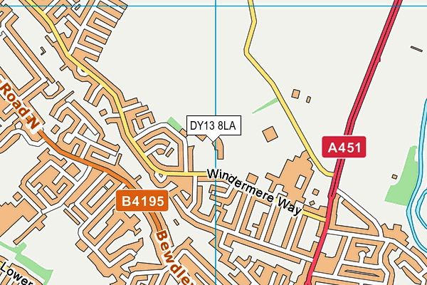
Burlish Park Primary School is located in Stourport-on-Severn and falls under the local authority of Worcestershire. This mixed-sex primary school has 439 pupils, with a capacity of 420, aged from three up to eleven, and the type of establishment is academy sponsor led. The most recend Ofsted inspection was 18th January 2023 resulting in an good rating.
| Address | Burlish Park Primary School Windermere Way Stourport-on-Severn Worcestershire DY13 8LA |
| Website | http://www.burlishpark.co.uk |
| Headteacher | Mrs Kerry Postans |
GetTheData
Source: Get Information About Schools
Licence: Open Government Licence
| Phase of Education | Primary |
| Type of Establishment | Academy sponsor led |
| Admissions Policy | Not applicable |
| Statutory Low Age | 3 |
| Statutory High Age | 11 |
| Boarders | No boarders |
| Official Sixth Form | Does not have a sixth form |
| Gender | Mixed |
| Religious Character | Does not apply |
| Diocese | Not applicable |
| Special Classes | Has Special Classes |
GetTheData
Source: Get Information About Schools
Licence: Open Government Licence
| Census Date | 19th January 2023 | |
| School Capacity | 420 | |
| Number of Pupils | 439 | 105% capacity |
| Number of Boys | 239 | 54% |
| Number of Girls | 200 | 46% |
| Free School Meals (%) | 11.80% |
GetTheData
Source: Get Information About Schools
Licence: Open Government Licence
| Street Address | Windermere Way |
| Town | Stourport-on-Severn |
| County | Worcestershire |
| Postcode | DY13 8LA |
| ➜ More DY13 8LA open data | |
GetTheData
Source: Get Information About Schools
Licence: Open Government Licence

GetTheData
Source: OS VectorMap District (Ordnance Survey)
Licence: Open Government Licence (requires attribution)
| Ofsted Last Inspection | 18th January 2023 |
| Ofsted Rating | Good |
| Ofsted Special Measures | Not applicable |
GetTheData
Source: Get Information About Schools
Licence: Open Government Licence
| Establishment Name | Burlish Park Primary School |
| Establishment Number | 2027 |
| Unique Reference Number | 146433 |
| Local Authority | Worcestershire |
| Local Authority Code | 885 |
| Previous Local Authority Code | 999 |
| Government Statistical Service Local Authority Code | E10000034 |
| Government Office Region | West Midlands |
| District | Wyre Forest |
| District Code | E07000239 |
| Ward | Mitton |
| Parliamentary Constituency | Wyre Forest |
| Urban/Rural Description | (England/Wales) Urban city and town |
| Middle Super Output Area | Wyre Forest 012 |
| Lower Super Output Area | Wyre Forest 012E |
GetTheData
Source: Get Information About Schools
Licence: Open Government Licence
| Establishment Status | Open |
| Last Changed Date | 14th September 2023 |
| Reason Establishment Opened | New Provision |
| Open Date | 1st October 2018 |
GetTheData
Source: Get Information About Schools
Licence: Open Government Licence
| Teenage Mothers | Not applicable |
| Special Educational Needs (SEN) Provision in Primary Care Unit | Not applicable |
| Pupil Referral Unit (PRU) Provides for Educational and Behavioural Difficulties (EBD) | Not applicable |
GetTheData
Source: Get Information About Schools
Licence: Open Government Licence
| Section 41 Approved | Not applicable |
| Special Educational Needs (SEN) Priority 1 | SLCN - Speech, language and Communication |
GetTheData
Source: Get Information About Schools
Licence: Open Government Licence
| Trust flag | Supported by a multi-academy trust |
| Trust | THE RIVERS C OF E MULTI ACADEMY TRUST |
| School Sponsor flag | Linked to a sponsor |
| School Sponsor | The Rivers C of E Multi Academy Trust |
GetTheData
Source: Get Information About Schools
Licence: Open Government Licence
| Federation flag | Not applicable |
GetTheData
Source: Get Information About Schools
Licence: Open Government Licence
| UK Provider Reference Number | 10081148 |
GetTheData
Source: Get Information About Schools
Licence: Open Government Licence
| Easting | 381189 |
| Northing | 272320 |
| Latitude | 52.34862 |
| Longitude | -2.27758 |
GetTheData
Source: Get Information About Schools
Licence: Open Government Licence
| School | Phase of Education | Distance |
|---|---|---|
| The Stourport High School and Sixth Form College Minster Road, Stourport-on-Severn, DY13 8AX | Secondary | 160m |
| Stourport Primary Academy Park Avenue, Stourport-on-Severn, DY13 8SH | Primary | 732m |
| St Wulstan's Catholic Primary School Elmfield Walk, Stourport-on-Severn, DY13 8UB | Primary | 1.2km |
| Wilden All Saints CofE Primary School Wilden Lane, Stourport-on-Severn, DY13 9LP | Primary | 1.3km |
| Lickhill Primary School Almond Way, Stourport-on-Severn, DY13 8UA | Primary | 1.3km |
| Continu Plus Academy Finepoint, Kidderminster, DY11 7FB | Not applicable | 1.3km |
| St Bartholomew's CofE VC Primary School Princess Way, Areley Kings, Stourport-on-Severn, DY13 0EL | Primary | 2.4km |
| Birchen Coppice Academy Woodbury Road, Kidderminster, DY11 7JJ | Primary | 2.5km |
| Hartlebury CofE Primary School The Village, Hartlebury, Kidderminster, DY11 7TD | Primary | 3.1km |
| The Bewdley School Stourport Road, Bewdley, DY12 1BL | Secondary | 3.2km |
GetTheData
Source: Get Information About Schools
Licence: Open Government Licence