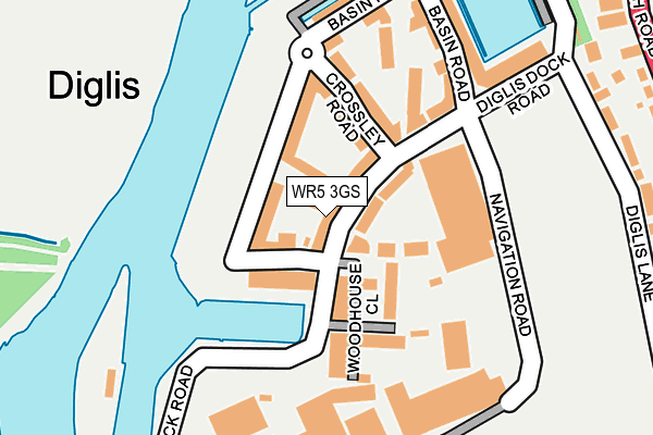
WR5 3GS is located in the Cathedral electoral ward, within the local authority district of Worcester and the English Parliamentary constituency of Worcester. The Sub Integrated Care Board (ICB) Location is NHS Herefordshire and Worcestershire ICB - 18C and the police force is West Mercia. This postcode has been in use since June 2017.


GetTheData
Source: OS OpenMap – Local (Ordnance Survey)
Source: OS VectorMap District (Ordnance Survey)
Licence: Open Government Licence (requires attribution)
| Easting | 384908 |
| Northing | 253635 |
| Latitude | 52.180769 |
| Longitude | -2.222135 |
GetTheData
Source: Open Postcode Geo
Licence: Open Government Licence
| Country | England |
| Postcode District | WR5 |
➜ See where WR5 is on a map ➜ Where is Worcester? | |
GetTheData
Source: Land Registry Price Paid Data
Licence: Open Government Licence
| Ward | Cathedral |
| Constituency | Worcester |
GetTheData
Source: ONS Postcode Database
Licence: Open Government Licence
| Navigation Road | Diglis | 273m |
| Waterfront Park (Diglis Road) | Diglis | 286m |
| Waterfront Park (Diglis Road) | Diglis | 292m |
| Diglis Lane | Diglis | 327m |
| The Hill Avenue (Bath Road (A38)) | Diglis | 329m |
| Worcester Foregate Street Station | 1.6km |
| Worcester Shrub Hill Station | 1.8km |
GetTheData
Source: NaPTAN
Licence: Open Government Licence
| Percentage of properties with Next Generation Access | 100.0% |
| Percentage of properties with Superfast Broadband | 100.0% |
| Percentage of properties with Ultrafast Broadband | 0.0% |
| Percentage of properties with Full Fibre Broadband | 0.0% |
Superfast Broadband is between 30Mbps and 300Mbps
Ultrafast Broadband is > 300Mbps
| Median download speed | 78.6Mbps |
| Average download speed | 66.9Mbps |
| Maximum download speed | 80.00Mbps |
| Median upload speed | 20.0Mbps |
| Average upload speed | 15.7Mbps |
| Maximum upload speed | 20.00Mbps |
| Percentage of properties unable to receive 2Mbps | 0.0% |
| Percentage of properties unable to receive 5Mbps | 0.0% |
| Percentage of properties unable to receive 10Mbps | 0.0% |
| Percentage of properties unable to receive 30Mbps | 0.0% |
GetTheData
Source: Ofcom
Licence: Ofcom Terms of Use (requires attribution)
GetTheData
Source: ONS Postcode Database
Licence: Open Government Licence


➜ Get more ratings from the Food Standards Agency
GetTheData
Source: Food Standards Agency
Licence: FSA terms & conditions
| Last Collection | |||
|---|---|---|---|
| Location | Mon-Fri | Sat | Distance |
| Diglis Dock Road | 17:00 | 11:30 | 158m |
| Hill Avenue | 16:30 | 11:30 | 350m |
| Cherry Orchard P.o. | 17:30 | 12:30 | 681m |
GetTheData
Source: Dracos
Licence: Creative Commons Attribution-ShareAlike
| Risk of WR5 3GS flooding from rivers and sea | Medium |
| ➜ WR5 3GS flood map | |
GetTheData
Source: Open Flood Risk by Postcode
Licence: Open Government Licence
The below table lists the International Territorial Level (ITL) codes (formerly Nomenclature of Territorial Units for Statistics (NUTS) codes) and Local Administrative Units (LAU) codes for WR5 3GS:
| ITL 1 Code | Name |
|---|---|
| TLG | West Midlands (England) |
| ITL 2 Code | Name |
| TLG1 | Herefordshire, Worcestershire and Warwickshire |
| ITL 3 Code | Name |
| TLG12 | Worcestershire CC |
| LAU 1 Code | Name |
| E07000237 | Worcester |
GetTheData
Source: ONS Postcode Directory
Licence: Open Government Licence
The below table lists the Census Output Area (OA), Lower Layer Super Output Area (LSOA), and Middle Layer Super Output Area (MSOA) for WR5 3GS:
| Code | Name | |
|---|---|---|
| OA | E00172273 | |
| LSOA | E01032295 | Worcester 013C |
| MSOA | E02006746 | Worcester 013 |
GetTheData
Source: ONS Postcode Directory
Licence: Open Government Licence
| WR5 3GJ | Cartwright Walk | 41m |
| WR5 3FR | Basin Road | 56m |
| WR5 3FQ | Woodhouse Close | 75m |
| WR5 3GR | Basin Road | 81m |
| WR5 3GH | Crossley Road | 94m |
| WR5 3FT | Woodhouse Close | 126m |
| WR5 3GE | Diglis Dock Road | 139m |
| WR5 3GB | Basin Road | 143m |
| WR5 3GF | Crossley Road | 154m |
| WR5 3GG | Layland Walk | 182m |
GetTheData
Source: Open Postcode Geo; Land Registry Price Paid Data
Licence: Open Government Licence