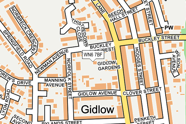
WN6 7BF is located in the Wigan West electoral ward, within the metropolitan district of Wigan and the English Parliamentary constituency of Wigan. The Sub Integrated Care Board (ICB) Location is NHS Greater Manchester ICB - 02H and the police force is Greater Manchester. This postcode has been in use since May 2017.


GetTheData
Source: OS OpenMap – Local (Ordnance Survey)
Source: OS VectorMap District (Ordnance Survey)
Licence: Open Government Licence (requires attribution)
| Easting | 357357 |
| Northing | 406771 |
| Latitude | 53.555835 |
| Longitude | -2.645169 |
GetTheData
Source: Open Postcode Geo
Licence: Open Government Licence
| Country | England |
| Postcode District | WN6 |
| ➜ WN6 open data dashboard ➜ See where WN6 is on a map ➜ Where is Wigan? | |
GetTheData
Source: Land Registry Price Paid Data
Licence: Open Government Licence
| Ward | Wigan West |
| Constituency | Wigan |
GetTheData
Source: ONS Postcode Database
Licence: Open Government Licence
| Gidlow Ln/Beech Hill Clinic (Gidlow Ln) | Gidlow | 119m |
| Buckley St/Barnsley St (Buckley St) | Gidlow | 185m |
| Gidlow Ln/Lynton Ave (Gidlow Ln) | Gidlow | 207m |
| Springfield Rd/Cecil Ave (Springfield Rd) | Springfield | 229m |
| Buckley St/Barnsley St (Buckley St) | Gidlow | 234m |
| Wigan Wallgate Station | 1.5km |
| Wigan North Western Station | 1.6km |
| Ince (Manchester) Station | 2.9km |
GetTheData
Source: NaPTAN
Licence: Open Government Licence
| Percentage of properties with Next Generation Access | 100.0% |
| Percentage of properties with Superfast Broadband | 100.0% |
| Percentage of properties with Ultrafast Broadband | 100.0% |
| Percentage of properties with Full Fibre Broadband | 0.0% |
Superfast Broadband is between 30Mbps and 300Mbps
Ultrafast Broadband is > 300Mbps
| Percentage of properties unable to receive 2Mbps | 0.0% |
| Percentage of properties unable to receive 5Mbps | 0.0% |
| Percentage of properties unable to receive 10Mbps | 0.0% |
| Percentage of properties unable to receive 30Mbps | 0.0% |
GetTheData
Source: Ofcom
Licence: Ofcom Terms of Use (requires attribution)
GetTheData
Source: ONS Postcode Database
Licence: Open Government Licence


➜ Get more ratings from the Food Standards Agency
GetTheData
Source: Food Standards Agency
Licence: FSA terms & conditions
| Last Collection | |||
|---|---|---|---|
| Location | Mon-Fri | Sat | Distance |
| Mesnes Road P O | 19:00 | 12:00 | 743m |
| Wrightington Street Bus Box | 965m | ||
| Wrightington Street | 19:05 | 12:10 | 966m |
GetTheData
Source: Dracos
Licence: Creative Commons Attribution-ShareAlike
| Facility | Distance |
|---|---|
| Wigan St Andrew's C Of E Junior And Infant School Mort Street, Wigan Grass Pitches | 430m |
| Woodhouse Playing Field St. Andrews Drive, Wigan Grass Pitches | 466m |
| St John Fisher Catholic High School (Wigan) Baytree Road, Wigan Grass Pitches, Sports Hall, Artificial Grass Pitch | 551m |
GetTheData
Source: Active Places
Licence: Open Government Licence
| School | Phase of Education | Distance |
|---|---|---|
| Sacred Heart Catholic Primary School Springfield Road, Sacred Heart Rc School, WIGAN, WN6 7RH | Primary | 436m |
| Wigan St Andrew's CofE Junior and Infant School Mort Street, Springfield, Wigan, WN6 7AU | Primary | 439m |
| Beech Hill Community Primary School Netherby Road, Beech Hill, Wigan, WN6 7PT | Primary | 511m |
GetTheData
Source: Edubase
Licence: Open Government Licence
The below table lists the International Territorial Level (ITL) codes (formerly Nomenclature of Territorial Units for Statistics (NUTS) codes) and Local Administrative Units (LAU) codes for WN6 7BF:
| ITL 1 Code | Name |
|---|---|
| TLD | North West (England) |
| ITL 2 Code | Name |
| TLD3 | Greater Manchester |
| ITL 3 Code | Name |
| TLD36 | Greater Manchester North West |
| LAU 1 Code | Name |
| E08000010 | Wigan |
GetTheData
Source: ONS Postcode Directory
Licence: Open Government Licence
The below table lists the Census Output Area (OA), Lower Layer Super Output Area (LSOA), and Middle Layer Super Output Area (MSOA) for WN6 7BF:
| Code | Name | |
|---|---|---|
| OA | E00031721 | |
| LSOA | E01006255 | Wigan 005C |
| MSOA | E02001291 | Wigan 005 |
GetTheData
Source: ONS Postcode Directory
Licence: Open Government Licence
| WN6 7PQ | Buckley Street West | 33m |
| WN6 7PG | Gidlow Lane | 66m |
| WN6 7BJ | Norfolk Street | 77m |
| WN6 7PE | Gidlow Lane | 107m |
| WN6 7PF | Gidlow Avenue | 117m |
| WN6 7JJ | Buckley Street | 131m |
| WN6 7PJ | Gidlow Lane | 135m |
| WN6 7PA | Thistledown Close | 146m |
| WN6 7RE | Newman Avenue | 157m |
| WN6 7RG | Manning Avenue | 158m |
GetTheData
Source: Open Postcode Geo; Land Registry Price Paid Data
Licence: Open Government Licence