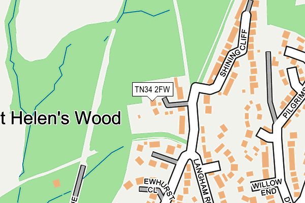
TN34 2FW is located in the St Helens electoral ward, within the local authority district of Hastings and the English Parliamentary constituency of Hastings and Rye. The Sub Integrated Care Board (ICB) Location is NHS Sussex ICB - 97R and the police force is Sussex. This postcode has been in use since June 2017.


GetTheData
Source: OS OpenMap – Local (Ordnance Survey)
Source: OS VectorMap District (Ordnance Survey)
Licence: Open Government Licence (requires attribution)
| Easting | 581631 |
| Northing | 111781 |
| Latitude | 50.876977 |
| Longitude | 0.580397 |
GetTheData
Source: Open Postcode Geo
Licence: Open Government Licence
| Country | England |
| Postcode District | TN34 |
| ➜ TN34 open data dashboard ➜ See where TN34 is on a map ➜ Where is Hastings? | |
GetTheData
Source: Land Registry Price Paid Data
Licence: Open Government Licence
| Ward | St Helens |
| Constituency | Hastings And Rye |
GetTheData
Source: ONS Postcode Database
Licence: Open Government Licence
2021 10 SEP £685,000 |
2018 26 JAN £400,000 |
4, WESTWOODS, HASTINGS, TN34 2FW 2017 30 NOV £615,000 |
2, WESTWOODS, HASTINGS, TN34 2FW 2017 27 OCT £690,000 |
GetTheData
Source: HM Land Registry Price Paid Data
Licence: Contains HM Land Registry data © Crown copyright and database right 2024. This data is licensed under the Open Government Licence v3.0.
| June 2022 | Burglary | On or near Willow End | 274m |
| June 2022 | Violence and sexual offences | On or near Pilgrims Way | 284m |
| June 2022 | Criminal damage and arson | On or near The Byeway | 423m |
| ➜ Get more crime data in our Crime section | |||
GetTheData
Source: data.police.uk
Licence: Open Government Licence
| Friars Way (Elphinstone Road) | St Helens | 475m |
| Downs Road | Blacklands | 480m |
| Friars Way (Elphinstone Road) | St Helens | 507m |
| Conifer Close (Downs Road) | Blacklands | 512m |
| Hoads Wood Road (Elphinstone Road) | St Helens | 539m |
| Ore Station | 1.4km |
| Hastings Station | 2.1km |
| St Leonards Warrior Square Station | 2.8km |
GetTheData
Source: NaPTAN
Licence: Open Government Licence
| Percentage of properties with Next Generation Access | 100.0% |
| Percentage of properties with Superfast Broadband | 100.0% |
| Percentage of properties with Ultrafast Broadband | 0.0% |
| Percentage of properties with Full Fibre Broadband | 0.0% |
Superfast Broadband is between 30Mbps and 300Mbps
Ultrafast Broadband is > 300Mbps
| Percentage of properties unable to receive 2Mbps | 0.0% |
| Percentage of properties unable to receive 5Mbps | 0.0% |
| Percentage of properties unable to receive 10Mbps | 0.0% |
| Percentage of properties unable to receive 30Mbps | 0.0% |
GetTheData
Source: Ofcom
Licence: Ofcom Terms of Use (requires attribution)
GetTheData
Source: ONS Postcode Database
Licence: Open Government Licence


➜ Get more ratings from the Food Standards Agency
GetTheData
Source: Food Standards Agency
Licence: FSA terms & conditions
| Last Collection | |||
|---|---|---|---|
| Location | Mon-Fri | Sat | Distance |
| Elphinstone Road (Upper) | 17:45 | 12:00 | 489m |
| Peter James Lane | 16:30 | 09:30 | 814m |
| Hillside Road | 17:00 | 12:00 | 828m |
GetTheData
Source: Dracos
Licence: Creative Commons Attribution-ShareAlike
| Facility | Distance |
|---|---|
| The Pilot Field Elphinstone Road, Hastings Grass Pitches | 468m |
| The Firs Elphinstone Road, Hastings Artificial Grass Pitch, Grass Pitches | 506m |
| Sandhurst Recreation Ground Sandhurst Gardens, Hastings Grass Pitches | 816m |
GetTheData
Source: Active Places
Licence: Open Government Licence
| School | Phase of Education | Distance |
|---|---|---|
| Ark Alexandra Academy Park Avenue, William Parker Campus, Hastings, TN34 2PG | Secondary | 821m |
| Ark Blacklands Primary Academy Osborne Close, Freshwater Avenue, Hastings, TN34 2HU | Primary | 909m |
| The Baird Primary Academy Parker Road, Hastings, TN34 3TH | Primary | 1.1km |
GetTheData
Source: Edubase
Licence: Open Government Licence
The below table lists the International Territorial Level (ITL) codes (formerly Nomenclature of Territorial Units for Statistics (NUTS) codes) and Local Administrative Units (LAU) codes for TN34 2FW:
| ITL 1 Code | Name |
|---|---|
| TLJ | South East (England) |
| ITL 2 Code | Name |
| TLJ2 | Surrey, East and West Sussex |
| ITL 3 Code | Name |
| TLJ22 | East Sussex CC |
| LAU 1 Code | Name |
| E07000062 | Hastings |
GetTheData
Source: ONS Postcode Directory
Licence: Open Government Licence
The below table lists the Census Output Area (OA), Lower Layer Super Output Area (LSOA), and Middle Layer Super Output Area (MSOA) for TN34 2FW:
| Code | Name | |
|---|---|---|
| OA | E00106682 | |
| LSOA | E01021007 | Hastings 002D |
| MSOA | E02004369 | Hastings 002 |
GetTheData
Source: ONS Postcode Directory
Licence: Open Government Licence
| TN34 2JN | St Helens Park Road | 113m |
| TN34 2RU | Woodcombe | 122m |
| TN34 2JR | Ewhurst Close | 152m |
| TN34 2JS | Old House Gardens | 199m |
| TN34 2JQ | Langham Close | 206m |
| TN34 2GT | Shining Cliff | 220m |
| TN34 2JD | Willow End | 243m |
| TN34 2LF | Pilgrims Way | 288m |
| TN34 2JG | Langham Road | 301m |
| TN34 2JA | Dunclutha Road | 316m |
GetTheData
Source: Open Postcode Geo; Land Registry Price Paid Data
Licence: Open Government Licence