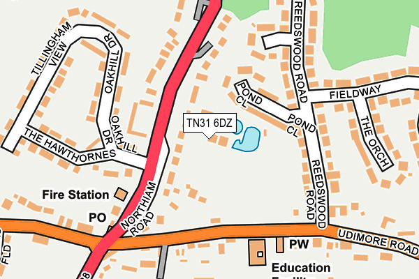
TN31 6DZ is located in the Brede & Udimore electoral ward, within the local authority district of Rother and the English Parliamentary constituency of Hastings and Rye. The Sub Integrated Care Board (ICB) Location is NHS Sussex ICB - 97R and the police force is Sussex. This postcode has been in use since March 2017.


GetTheData
Source: OS OpenMap – Local (Ordnance Survey)
Source: OS VectorMap District (Ordnance Survey)
Licence: Open Government Licence (requires attribution)
| Easting | 582741 |
| Northing | 119961 |
| Latitude | 50.950110 |
| Longitude | 0.600252 |
GetTheData
Source: Open Postcode Geo
Licence: Open Government Licence
| Country | England |
| Postcode District | TN31 |
| ➜ TN31 open data dashboard ➜ See where TN31 is on a map ➜ Where is Broad Oak? | |
GetTheData
Source: Land Registry Price Paid Data
Licence: Open Government Licence
| Ward | Brede & Udimore |
| Constituency | Hastings And Rye |
GetTheData
Source: ONS Postcode Database
Licence: Open Government Licence
| June 2022 | Violence and sexual offences | On or near Sports/Recreation Area | 87m |
| June 2022 | Violence and sexual offences | On or near Sports/Recreation Area | 87m |
| June 2022 | Public order | On or near Oakhill Drive | 161m |
| ➜ Get more crime data in our Crime section | |||
GetTheData
Source: data.police.uk
Licence: Open Government Licence
| Oakhill Drive (Northiam Road) | Broad Oak | 63m |
| Oakhill Drive (Northiam Road) | Broad Oak | 87m |
| Pond Close | Broad Oak | 93m |
| Fire Station (Northiam Road) | Broad Oak | 122m |
| Recreation Ground (Udimore Road) | Broad Oak | 127m |
| Doleham Station | 3.6km |
GetTheData
Source: NaPTAN
Licence: Open Government Licence
| Percentage of properties with Next Generation Access | 100.0% |
| Percentage of properties with Superfast Broadband | 100.0% |
| Percentage of properties with Ultrafast Broadband | 0.0% |
| Percentage of properties with Full Fibre Broadband | 0.0% |
Superfast Broadband is between 30Mbps and 300Mbps
Ultrafast Broadband is > 300Mbps
| Percentage of properties unable to receive 2Mbps | 0.0% |
| Percentage of properties unable to receive 5Mbps | 0.0% |
| Percentage of properties unable to receive 10Mbps | 0.0% |
| Percentage of properties unable to receive 30Mbps | 0.0% |
GetTheData
Source: Ofcom
Licence: Ofcom Terms of Use (requires attribution)
GetTheData
Source: ONS Postcode Database
Licence: Open Government Licence


➜ Get more ratings from the Food Standards Agency
GetTheData
Source: Food Standards Agency
Licence: FSA terms & conditions
| Last Collection | |||
|---|---|---|---|
| Location | Mon-Fri | Sat | Distance |
| Cackle Street | 17:00 | 09:00 | 1,186m |
| Brede Church | 17:00 | 09:00 | 1,642m |
| Mill Corner | 16:30 | 10:00 | 3,732m |
GetTheData
Source: Dracos
Licence: Creative Commons Attribution-ShareAlike
| Facility | Distance |
|---|---|
| Broad Oak Recreation Ground Udimore Road, Broad Oak Grass Pitches | 90m |
| Frewen College Rye Road, Northiam, Rye Swimming Pool, Health and Fitness Gym, Grass Pitches | 4.1km |
| Westfield Cricket Club Main Road, Westfield, Hastings Grass Pitches | 4.2km |
GetTheData
Source: Active Places
Licence: Open Government Licence
| School | Phase of Education | Distance |
|---|---|---|
| Brede Primary School Udimore Road, Broad Oak, Brede, Rye, TN31 6DG | Primary | 178m |
| Frewen College Northiam, Rye, TN31 6NL | Not applicable | 4.1km |
| Northiam Church of England Primary School and Nursery Main Street, Northiam, Rye, TN31 6NB | Primary | 4.3km |
GetTheData
Source: Edubase
Licence: Open Government Licence
The below table lists the International Territorial Level (ITL) codes (formerly Nomenclature of Territorial Units for Statistics (NUTS) codes) and Local Administrative Units (LAU) codes for TN31 6DZ:
| ITL 1 Code | Name |
|---|---|
| TLJ | South East (England) |
| ITL 2 Code | Name |
| TLJ2 | Surrey, East and West Sussex |
| ITL 3 Code | Name |
| TLJ22 | East Sussex CC |
| LAU 1 Code | Name |
| E07000064 | Rother |
GetTheData
Source: ONS Postcode Directory
Licence: Open Government Licence
The below table lists the Census Output Area (OA), Lower Layer Super Output Area (LSOA), and Middle Layer Super Output Area (MSOA) for TN31 6DZ:
| Code | Name | |
|---|---|---|
| OA | E00107101 | |
| LSOA | E01021088 | Rother 005B |
| MSOA | E02004396 | Rother 005 |
GetTheData
Source: ONS Postcode Directory
Licence: Open Government Licence
| TN31 6DS | Northiam Road | 41m |
| TN31 6DR | Pond Close | 104m |
| TN31 6DH | Reedswood Road | 167m |
| TN31 6DJ | Chestnut Close | 175m |
| TN31 6DT | Oakhill Drive | 178m |
| TN31 6DG | Udimore Road | 178m |
| TN31 6DP | The Orchard | 226m |
| TN31 6EN | The Hawthornes | 245m |
| TN31 6EL | Tillingham View | 268m |
| TN31 6DL | Fieldway | 299m |
GetTheData
Source: Open Postcode Geo; Land Registry Price Paid Data
Licence: Open Government Licence