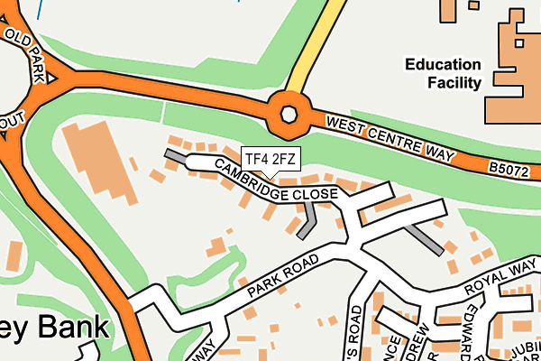
TF4 2FZ is located in the Malinslee & Dawley Bank electoral ward, within the unitary authority of Telford and Wrekin and the English Parliamentary constituency of Telford. The Sub Integrated Care Board (ICB) Location is NHS Shropshire, Telford and Wrekin ICB - M2L0M and the police force is West Mercia. This postcode has been in use since April 2017.


GetTheData
Source: OS OpenMap – Local (Ordnance Survey)
Source: OS VectorMap District (Ordnance Survey)
Licence: Open Government Licence (requires attribution)
| Easting | 368828 |
| Northing | 308855 |
| Latitude | 52.676508 |
| Longitude | -2.462472 |
GetTheData
Source: Open Postcode Geo
Licence: Open Government Licence
| Country | England |
| Postcode District | TF4 |
| ➜ TF4 open data dashboard ➜ See where TF4 is on a map ➜ Where is Telford? | |
GetTheData
Source: Land Registry Price Paid Data
Licence: Open Government Licence
| Ward | Malinslee & Dawley Bank |
| Constituency | Telford |
GetTheData
Source: ONS Postcode Database
Licence: Open Government Licence
| January 2024 | Anti-social behaviour | On or near Prince Charles Crescent | 433m |
| December 2023 | Criminal damage and arson | On or near Prince Edward Crescent | 329m |
| December 2023 | Violence and sexual offences | On or near Prince Edward Crescent | 329m |
| ➜ Get more crime data in our Crime section | |||
GetTheData
Source: data.police.uk
Licence: Open Government Licence
| St Christophers Way (Park Road) | Malins Lee | 170m |
| St Christophers Way (Park Road) | Malins Lee | 189m |
| St Davids Close (St. Leonard's Road) | Malins Lee | 208m |
| St Davids Close (St. Leonard's Road) | Malins Lee | 255m |
| Prince Edward Crescent (Royal Way) | Malins Lee | 290m |
| Telford Central Station | 1.5km |
| Oakengates Station | 2.1km |
| Wellington (Shropshire) Station | 4.6km |
GetTheData
Source: NaPTAN
Licence: Open Government Licence
➜ Broadband speed and availability dashboard for TF4 2FZ
| Percentage of properties with Next Generation Access | 100.0% |
| Percentage of properties with Superfast Broadband | 100.0% |
| Percentage of properties with Ultrafast Broadband | 100.0% |
| Percentage of properties with Full Fibre Broadband | 0.0% |
Superfast Broadband is between 30Mbps and 300Mbps
Ultrafast Broadband is > 300Mbps
| Median download speed | 21.2Mbps |
| Average download speed | 65.8Mbps |
| Maximum download speed | 350.00Mbps |
| Median upload speed | 1.1Mbps |
| Average upload speed | 2.4Mbps |
| Maximum upload speed | 9.28Mbps |
| Percentage of properties unable to receive 2Mbps | 0.0% |
| Percentage of properties unable to receive 5Mbps | 0.0% |
| Percentage of properties unable to receive 10Mbps | 0.0% |
| Percentage of properties unable to receive 30Mbps | 0.0% |
➜ Broadband speed and availability dashboard for TF4 2FZ
GetTheData
Source: Ofcom
Licence: Ofcom Terms of Use (requires attribution)
GetTheData
Source: ONS Postcode Database
Licence: Open Government Licence


➜ Get more ratings from the Food Standards Agency
GetTheData
Source: Food Standards Agency
Licence: FSA terms & conditions
| Last Collection | |||
|---|---|---|---|
| Location | Mon-Fri | Sat | Distance |
| Lawley | 17:30 | 11:00 | 688m |
| Malinslee Centre | 17:30 | 11:00 | 720m |
| Bellpitt Road | 17:30 | 11:00 | 727m |
GetTheData
Source: Dracos
Licence: Creative Commons Attribution-ShareAlike
| Facility | Distance |
|---|---|
| Thomas Telford School Old Park, Telford Swimming Pool, Artificial Grass Pitch, Sports Hall, Health and Fitness Gym, Grass Pitches, Studio, Outdoor Tennis Courts | 317m |
| Malinslee Playing Fields Alma Avenue, Dawley, Telford Grass Pitches, Cycling | 482m |
| Ladygrove Primary School Old Office Road, Dawley, Telford Grass Pitches | 818m |
GetTheData
Source: Active Places
Licence: Open Government Licence
| School | Phase of Education | Distance |
|---|---|---|
| Thomas Telford School Old Park, Telford, TF3 4NW | Not applicable | 307m |
| Old Park Primary School Brunel Road, Malinslee, Telford, TF3 2BF | Primary | 631m |
| Ladygrove Primary School Old Office Road, Dawley, Telford, TF4 2LF | Primary | 1km |
GetTheData
Source: Edubase
Licence: Open Government Licence
The below table lists the International Territorial Level (ITL) codes (formerly Nomenclature of Territorial Units for Statistics (NUTS) codes) and Local Administrative Units (LAU) codes for TF4 2FZ:
| ITL 1 Code | Name |
|---|---|
| TLG | West Midlands (England) |
| ITL 2 Code | Name |
| TLG2 | Shropshire and Staffordshire |
| ITL 3 Code | Name |
| TLG21 | Telford and Wrekin |
| LAU 1 Code | Name |
| E06000020 | Telford and Wrekin |
GetTheData
Source: ONS Postcode Directory
Licence: Open Government Licence
The below table lists the Census Output Area (OA), Lower Layer Super Output Area (LSOA), and Middle Layer Super Output Area (MSOA) for TF4 2FZ:
| Code | Name | |
|---|---|---|
| OA | E00071494 | |
| LSOA | E01014158 | Telford and Wrekin 016E |
| MSOA | E02002943 | Telford and Wrekin 016 |
GetTheData
Source: ONS Postcode Directory
Licence: Open Government Licence
| TF4 2JA | St Christophers Way | 218m |
| TF4 2AX | Park Road | 224m |
| TF3 2JT | Prince Andrew Drive | 233m |
| TF4 2JE | St Davids Close | 255m |
| TF4 2JD | St Davids Close | 301m |
| TF3 2JS | Queen Elizabeth Way | 317m |
| TF4 2JB | St Christophers Way | 328m |
| TF3 2JU | Prince Edward Crescent | 329m |
| TF4 2BH | Edward Parry Court | 336m |
| TF4 2EB | St Leonards Road | 349m |
GetTheData
Source: Open Postcode Geo; Land Registry Price Paid Data
Licence: Open Government Licence