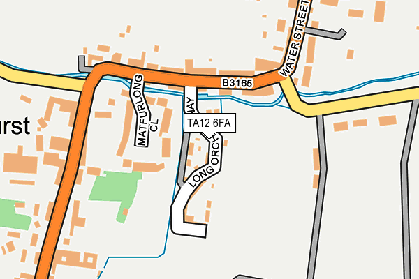
TA12 6FA is located in the Martock electoral ward, within the unitary authority of Somerset and the English Parliamentary constituency of Somerton and Frome. The Sub Integrated Care Board (ICB) Location is NHS Somerset ICB - 11X and the police force is Avon and Somerset. This postcode has been in use since April 2017.


GetTheData
Source: OS OpenMap – Local (Ordnance Survey)
Source: OS VectorMap District (Ordnance Survey)
Licence: Open Government Licence (requires attribution)
| Easting | 345962 |
| Northing | 118808 |
| Latitude | 50.966137 |
| Longitude | -2.770904 |
GetTheData
Source: Open Postcode Geo
Licence: Open Government Licence
| Country | England |
| Postcode District | TA12 |
| ➜ TA12 open data dashboard ➜ See where TA12 is on a map ➜ Where is Martock? | |
GetTheData
Source: Land Registry Price Paid Data
Licence: Open Government Licence
| Ward | Martock |
| Constituency | Somerton And Frome |
GetTheData
Source: ONS Postcode Database
Licence: Open Government Licence
2021 9 NOV £415,000 |
2018 24 JUL £330,000 |
8, LONG ORCHARD WAY, MARTOCK, TA12 6FA 2017 10 NOV £295,000 |
18, LONG ORCHARD WAY, MARTOCK, TA12 6FA 2017 24 AUG £340,000 |
20, LONG ORCHARD WAY, MARTOCK, TA12 6FA 2017 26 JUN £340,000 |
GetTheData
Source: HM Land Registry Price Paid Data
Licence: Contains HM Land Registry data © Crown copyright and database right 2024. This data is licensed under the Open Government Licence v3.0.
| June 2022 | Violence and sexual offences | On or near Petrol Station | 179m |
| June 2022 | Violence and sexual offences | On or near Petrol Station | 179m |
| June 2022 | Other theft | On or near Hurst | 226m |
| ➜ Get more crime data in our Crime section | |||
GetTheData
Source: data.police.uk
Licence: Open Government Licence
| The Pinnacle (North Street) | Martock | 567m |
| The Pinnacle (East Street) | Hurst | 569m |
| Post Office (Bower Hinton) | Bower Hinton | 623m |
| The Pinnacle (North Street) | Martock | 668m |
| The Green (B3165) | Bower Hinton | 846m |
GetTheData
Source: NaPTAN
Licence: Open Government Licence
➜ Broadband speed and availability dashboard for TA12 6FA
| Percentage of properties with Next Generation Access | 97.0% |
| Percentage of properties with Superfast Broadband | 97.0% |
| Percentage of properties with Ultrafast Broadband | 0.0% |
| Percentage of properties with Full Fibre Broadband | 0.0% |
Superfast Broadband is between 30Mbps and 300Mbps
Ultrafast Broadband is > 300Mbps
| Median download speed | 22.3Mbps |
| Average download speed | 40.0Mbps |
| Maximum download speed | 80.00Mbps |
| Median upload speed | 1.3Mbps |
| Average upload speed | 8.3Mbps |
| Maximum upload speed | 20.00Mbps |
| Percentage of properties unable to receive 2Mbps | 0.0% |
| Percentage of properties unable to receive 5Mbps | 0.0% |
| Percentage of properties unable to receive 10Mbps | 0.0% |
| Percentage of properties unable to receive 30Mbps | 0.0% |
➜ Broadband speed and availability dashboard for TA12 6FA
GetTheData
Source: Ofcom
Licence: Ofcom Terms of Use (requires attribution)
GetTheData
Source: ONS Postcode Database
Licence: Open Government Licence


➜ Get more ratings from the Food Standards Agency
GetTheData
Source: Food Standards Agency
Licence: FSA terms & conditions
| Last Collection | |||
|---|---|---|---|
| Location | Mon-Fri | Sat | Distance |
| Water Street | 16:30 | 09:30 | 131m |
| Martock Post Office | 17:00 | 12:30 | 602m |
| East Street | 16:30 | 08:00 | 932m |
GetTheData
Source: Dracos
Licence: Creative Commons Attribution-ShareAlike
| Facility | Distance |
|---|---|
| Martock Recreation Ground Stoke Road, Martock Grass Pitches, Outdoor Tennis Courts | 172m |
| Martock Parish Hall Church Street, Martock Sports Hall | 452m |
| Fit Martock (Closed) North Street, Martock Health and Fitness Gym | 1.3km |
GetTheData
Source: Active Places
Licence: Open Government Licence
| School | Phase of Education | Distance |
|---|---|---|
| Martock Church of England VA Primary School Elmleigh Road, Martock, TA12 6EF | Primary | 608m |
| Castle Primary School Castle Street, Stoke-Sub-Hamdon, TA14 6RE | Primary | 2km |
| Ash Church of England Primary School Main Street, Ash, Martock, TA12 6NS | Primary | 2.3km |
GetTheData
Source: Edubase
Licence: Open Government Licence
The below table lists the International Territorial Level (ITL) codes (formerly Nomenclature of Territorial Units for Statistics (NUTS) codes) and Local Administrative Units (LAU) codes for TA12 6FA:
| ITL 1 Code | Name |
|---|---|
| TLK | South West (England) |
| ITL 2 Code | Name |
| TLK2 | Dorset and Somerset |
| ITL 3 Code | Name |
| TLK23 | Somerset CC |
| LAU 1 Code | Name |
| E07000189 | South Somerset |
GetTheData
Source: ONS Postcode Directory
Licence: Open Government Licence
The below table lists the Census Output Area (OA), Lower Layer Super Output Area (LSOA), and Middle Layer Super Output Area (MSOA) for TA12 6FA:
| Code | Name | |
|---|---|---|
| OA | E00148774 | |
| LSOA | E01029204 | South Somerset 009C |
| MSOA | E02006083 | South Somerset 009 |
GetTheData
Source: ONS Postcode Directory
Licence: Open Government Licence
| TA12 6LD | Matfurlong Close | 74m |
| TA12 6JP | Water Street | 159m |
| TA12 6JN | Water Street | 204m |
| TA12 6JU | 213m | |
| TA12 6AF | Stoke Road | 280m |
| TA12 6LU | Pound Lane | 315m |
| TA12 6JY | 425m | |
| TA12 6DS | Church Close | 467m |
| TA12 6JL | Church Street | 479m |
| TA12 6JZ | Bower Hinton | 530m |
GetTheData
Source: Open Postcode Geo; Land Registry Price Paid Data
Licence: Open Government Licence