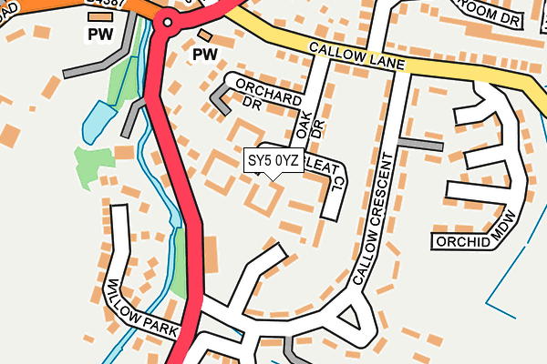
SY5 0YZ is located in the Rea Valley electoral ward, within the unitary authority of Shropshire and the English Parliamentary constituency of Shrewsbury and Atcham. The Sub Integrated Care Board (ICB) Location is NHS Shropshire, Telford and Wrekin ICB - M2L0M and the police force is West Mercia. This postcode has been in use since February 2017.


GetTheData
Source: OS OpenMap – Local (Ordnance Survey)
Source: OS VectorMap District (Ordnance Survey)
Licence: Open Government Licence (requires attribution)
| Easting | 337588 |
| Northing | 304876 |
| Latitude | 52.638039 |
| Longitude | -2.923711 |
GetTheData
Source: Open Postcode Geo
Licence: Open Government Licence
| Country | England |
| Postcode District | SY5 |
| ➜ SY5 open data dashboard ➜ See where SY5 is on a map | |
GetTheData
Source: Land Registry Price Paid Data
Licence: Open Government Licence
| Ward | Rea Valley |
| Constituency | Shrewsbury And Atcham |
GetTheData
Source: ONS Postcode Database
Licence: Open Government Licence
| December 2023 | Violence and sexual offences | On or near Callow Crescent | 74m |
| December 2023 | Other theft | On or near Callow Crescent | 74m |
| December 2023 | Anti-social behaviour | On or near Callow Crescent | 74m |
| ➜ Get more crime data in our Crime section | |||
GetTheData
Source: data.police.uk
Licence: Open Government Licence
| Village Hall (A488) | Minsterley | 124m |
| Village Hall (A488) | Minsterley | 160m |
| Crown & Sceptre (A488) | Minsterley | 192m |
| Memorial (A488) | Minsterley | 206m |
| Creamery (A488) | Minsterley | 234m |
GetTheData
Source: NaPTAN
Licence: Open Government Licence
GetTheData
Source: ONS Postcode Database
Licence: Open Government Licence


➜ Get more ratings from the Food Standards Agency
GetTheData
Source: Food Standards Agency
Licence: FSA terms & conditions
| Last Collection | |||
|---|---|---|---|
| Location | Mon-Fri | Sat | Distance |
| Longleat Close | 17:00 | 08:45 | 41m |
| Minsterley Post Office | 17:00 | 12:00 | 265m |
| Grove | 16:00 | 07:30 | 520m |
GetTheData
Source: Dracos
Licence: Creative Commons Attribution-ShareAlike
| Facility | Distance |
|---|---|
| Minsterley Playing Fields Callow Crescent, Minsterley, Shrewsbury Grass Pitches | 306m |
| Eastridge Woods Pontesbury, Shrewsbury Cycling | 2km |
| Dickens Field (Closed) Hampton Beech, Worthen, Shrewsbury Grass Pitches | 2.6km |
GetTheData
Source: Active Places
Licence: Open Government Licence
| School | Phase of Education | Distance |
|---|---|---|
| Minsterley Primary School Minsterley, Shrewsbury, SY5 0BE | Primary | 305m |
| Pontesbury CofE Primary School Bogey Lane, Pontesbury, Pontesbury CE Primary School, Shrewsbury, SY5 0TF | Primary | 2.9km |
| Mary Webb School and Science College Pontesbury, Shrewsbury, SY5 0TG | Secondary | 3km |
GetTheData
Source: Edubase
Licence: Open Government Licence
The below table lists the International Territorial Level (ITL) codes (formerly Nomenclature of Territorial Units for Statistics (NUTS) codes) and Local Administrative Units (LAU) codes for SY5 0YZ:
| ITL 1 Code | Name |
|---|---|
| TLG | West Midlands (England) |
| ITL 2 Code | Name |
| TLG2 | Shropshire and Staffordshire |
| ITL 3 Code | Name |
| TLG22 | Shropshire |
| LAU 1 Code | Name |
| E06000051 | Shropshire |
GetTheData
Source: ONS Postcode Directory
Licence: Open Government Licence
The below table lists the Census Output Area (OA), Lower Layer Super Output Area (LSOA), and Middle Layer Super Output Area (MSOA) for SY5 0YZ:
| Code | Name | |
|---|---|---|
| OA | E00147555 | |
| LSOA | E01028975 | Shropshire 026C |
| MSOA | E02006039 | Shropshire 026 |
GetTheData
Source: ONS Postcode Directory
Licence: Open Government Licence
| SY5 0YX | Longleat Close | 0m |
| SY5 0DD | Callow Crescent | 88m |
| SY5 0DG | Orchard Drive | 99m |
| SY5 0DE | Oak Drive | 102m |
| SY5 0DB | Callow Crescent | 105m |
| SY5 0BE | 119m | |
| SY5 0BZ | Callow Crescent | 138m |
| SY5 0BB | The Square | 177m |
| SY5 0EH | Willow Park | 188m |
| SY5 0DF | Callow Lane | 204m |
GetTheData
Source: Open Postcode Geo; Land Registry Price Paid Data
Licence: Open Government Licence