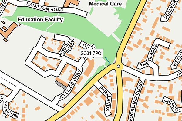
SO31 7PQ is located in the Park Gate electoral ward, within the local authority district of Fareham and the English Parliamentary constituency of Fareham. The Sub Integrated Care Board (ICB) Location is NHS Hampshire and Isle of Wight ICB - D9Y0V and the police force is Hampshire. This postcode has been in use since March 2017.


GetTheData
Source: OS OpenMap – Local (Ordnance Survey)
Source: OS VectorMap District (Ordnance Survey)
Licence: Open Government Licence (requires attribution)
| Easting | 451052 |
| Northing | 107894 |
| Latitude | 50.868293 |
| Longitude | -1.275876 |
GetTheData
Source: Open Postcode Geo
Licence: Open Government Licence
| Country | England |
| Postcode District | SO31 |
| ➜ SO31 open data dashboard ➜ See where SO31 is on a map ➜ Where is Locks Heath? | |
GetTheData
Source: Land Registry Price Paid Data
Licence: Open Government Licence
| Ward | Park Gate |
| Constituency | Fareham |
GetTheData
Source: ONS Postcode Database
Licence: Open Government Licence
| December 2023 | Anti-social behaviour | On or near Hollybrook Gardens | 425m |
| November 2023 | Violence and sexual offences | On or near Chine Close | 308m |
| May 2023 | Anti-social behaviour | On or near Hollybrook Gardens | 425m |
| ➜ Get more crime data in our Crime section | |||
GetTheData
Source: data.police.uk
Licence: Open Government Licence
| Brookfield Community School (Brook Lane) | Locks Heath | 181m |
| Community Hospital (Unnamed Road) | Park Gate | 257m |
| Battle Close (Lockswood Road) | Locks Heath | 325m |
| Headland Drive (Locks Road) | Locks Heath | 433m |
| Headland Drive (Locks Road) | Locks Heath | 443m |
| Swanwick Station | 1.1km |
| Bursledon Station | 2.7km |
| Hamble Station | 3.8km |
GetTheData
Source: NaPTAN
Licence: Open Government Licence
➜ Broadband speed and availability dashboard for SO31 7PQ
| Percentage of properties with Next Generation Access | 100.0% |
| Percentage of properties with Superfast Broadband | 100.0% |
| Percentage of properties with Ultrafast Broadband | 0.0% |
| Percentage of properties with Full Fibre Broadband | 0.0% |
Superfast Broadband is between 30Mbps and 300Mbps
Ultrafast Broadband is > 300Mbps
| Median download speed | 27.2Mbps |
| Average download speed | 24.1Mbps |
| Maximum download speed | 51.55Mbps |
| Median upload speed | 7.0Mbps |
| Average upload speed | 5.0Mbps |
| Maximum upload speed | 9.96Mbps |
| Percentage of properties unable to receive 2Mbps | 0.0% |
| Percentage of properties unable to receive 5Mbps | 0.0% |
| Percentage of properties unable to receive 10Mbps | 0.0% |
| Percentage of properties unable to receive 30Mbps | 0.0% |
➜ Broadband speed and availability dashboard for SO31 7PQ
GetTheData
Source: Ofcom
Licence: Ofcom Terms of Use (requires attribution)
GetTheData
Source: ONS Postcode Database
Licence: Open Government Licence


➜ Get more ratings from the Food Standards Agency
GetTheData
Source: Food Standards Agency
Licence: FSA terms & conditions
| Last Collection | |||
|---|---|---|---|
| Location | Mon-Fri | Sat | Distance |
| Sarisbury Grn Delivery Office | 17:30 | 11:30 | 311m |
| Bookfield Gardens | 17:30 | 07:30 | 393m |
| Locks Road | 16:45 | 07:30 | 442m |
GetTheData
Source: Dracos
Licence: Creative Commons Attribution-ShareAlike
| Facility | Distance |
|---|---|
| Lord Wilson Academy Trust Montefiore Drive, Sarisbury Green, Southampton Sports Hall, Grass Pitches | 299m |
| Holly Hill Football Pitches Barnes Lane, Sarisbury Green, Southampton Grass Pitches | 511m |
| Anytime Fitness (Locks Heath) Centre Way, Centre Way, Locks Heath, Southampton Health and Fitness Gym | 549m |
GetTheData
Source: Active Places
Licence: Open Government Licence
| School | Phase of Education | Distance |
|---|---|---|
| LWS Academy Montefiore Drive, Sarisbury Green, Southampton, SO31 7NL | Not applicable | 320m |
| Brookfield Community School Brook Lane, Sarisbury Green, Southampton, SO31 7DU | Secondary | 636m |
| Park Gate Primary School Northmore Road, Park Gate, Southampton, SO31 6LX | Primary | 649m |
GetTheData
Source: Edubase
Licence: Open Government Licence
The below table lists the International Territorial Level (ITL) codes (formerly Nomenclature of Territorial Units for Statistics (NUTS) codes) and Local Administrative Units (LAU) codes for SO31 7PQ:
| ITL 1 Code | Name |
|---|---|
| TLJ | South East (England) |
| ITL 2 Code | Name |
| TLJ3 | Hampshire and Isle of Wight |
| ITL 3 Code | Name |
| TLJ35 | South Hampshire |
| LAU 1 Code | Name |
| E07000087 | Fareham |
GetTheData
Source: ONS Postcode Directory
Licence: Open Government Licence
The below table lists the Census Output Area (OA), Lower Layer Super Output Area (LSOA), and Middle Layer Super Output Area (MSOA) for SO31 7PQ:
| Code | Name | |
|---|---|---|
| OA | E00115660 | |
| LSOA | E01022754 | Fareham 002C |
| MSOA | E02004728 | Fareham 002 |
GetTheData
Source: ONS Postcode Directory
Licence: Open Government Licence
| SO31 7NX | Jerram Place | 39m |
| SO31 7NY | Burney Place | 106m |
| SO31 7NW | Jellicoe Drive | 111m |
| SO31 6WR | Lockswood Keep | 132m |
| SO31 7WR | Parklands | 151m |
| SO31 7NQ | Cecil Gardens | 175m |
| SO31 6UX | The Glades | 178m |
| SO31 7DP | Brook Lane | 190m |
| SO31 6WE | Moorland Close | 201m |
| SO31 6WD | Moorland Close | 225m |
GetTheData
Source: Open Postcode Geo; Land Registry Price Paid Data
Licence: Open Government Licence